Using the ArcView Project
Data collected as part of the Klamath Basin Pilot Project were organized into an ArcView GIS project. The project is accessed by starting the ArcView software (Version 3.0 or above) and opening the "klam98.apr" project file. The project is system independent and can be opened from either a UNIX or PC platform. The data list provides a detailed description of the data themes associated with this project.
The three themes generated from this study include the locations of the chinook salmon from the radio tracking survey (Chinook Salmon Tracking), pool locations mapped from the field survey (Pools), and image locations from the airborne thermal survey (Thermal Survey). The points in the thermal survey are color coded to represent the median temperature found in each of the sampled images. The stream network for the entire basin as well as USGS 1:24K digital raster graphics (DRG) files are provided as reference themes. The DRG themes are named based on the 7.5 minute quadrangle names listed in the publication: USGS, California Index to Topographic and other Map Coverage. The DRGs are set in the "Theme Properties" to only display at a maximum scale of 1:40K.
The following sections describe how to display images associated with the thermal survey and also discusses how to move the project to a different location.
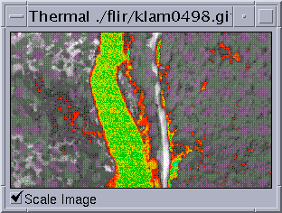
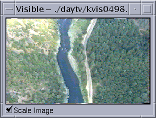
The points in the Thermal Survey theme represent the location of a thermal/day TV image pair. When Thermal Survey
is the active theme, the thermal and corresponding day TV images can be displayed using the hotlink tool, ![]() , on the View Toolbar and clicking on any
point in the theme. The hotlink tool has been configured to run a script named Display.Two (included in the
Project). The script reads the image file name for the selected point from the Thermal Survey Attribute file
and displays the images in two seperate image windows.
, on the View Toolbar and clicking on any
point in the theme. The hotlink tool has been configured to run a script named Display.Two (included in the
Project). The script reads the image file name for the selected point from the Thermal Survey Attribute file
and displays the images in two seperate image windows.
Notes:
- The "Display.Two" script reads the file names from the fields "Image_Path" and "VImage_Path" in the thermal survey attribute table. If these field names change, the script will have to be modified and recompiled.
- The GPS position is the location of the aircraft at the time the image was acquired and the positions were not differentially corrected. As a result, the image locations in the point coverage do not represent exact on the ground locations. Examination of the images in relation to features on the base maps indicate that the ground area displayed in the image is often 100m to 400m upstream of the point on the map.
- Once displayed, the image windows are independent of the ArcView Project. Displaying images for another point will create a new window and - consequently - it is easy to accumulate alot of open windows. One should be careful to close the images that are no longer required.
- The thermal and day TV image frames were collected to show the same ground area. However, timing differences in the digital frame grabbing sometimes results in a discrepency between the images. These differences are typically less then 1/2 the image frame.
- Consecutive images typically have about 10% overlap. This is done to provide continuous coverage of the river.
The AV project can be viewed directly from the CD-ROM or copied to a local or network drive. The project can be copied directly as long as the directory structure on the CD is maintained. If not, you will have to "point" ArcView to the new locations of the data sets (shapefiles) and the DRG images.
If the thermal and day TV images are moved, the hotlink tool used to display the images will no longer work. The easiest way to fix this is to edit the records in the "Image_Path" and "VImage_Path" fields in the Thermal Survey attribute table. The records are modified by replacing the old path with the new path using the "substitute" function.