In April 1993, President Clinton commissioned an interagency scientific team to develop a set of alternatives for management of ecosystems within the range of the northern spotted owl. This effort culminated in the report by the Forest Ecosystem Management Assessment Team (FEMAT) entitled Forest Ecosystem Management: An Ecological, Economic, and Social Assessment (FEMAT) in July 1993 (Thomas, 1993). The report provides the scientific basis from which to implement ecosystem management in the Pacific Northwest. It addresses the species and habitat needs on a regional scale, providing a multi-faceted conservation strategy from which basin-scale, watershed-scale, and eventually site-level restoration planning can be placed in a regional context.
The FEMAT report was utilized as a cornerstone in the development of the Final Supplemental Environmental Impact Statement (FSEIS) for Amendments to Forest Service and Bureau of Land Management Planning Documents Within the Range of the Northern Spotted Owl. The Record of Decision (ROD) for this FSEIS was signed in April, 1994 (USDA FS and USDI BLM, 1994b). The ROD formalized ecosystem management as the land management policy in the Pacific Northwest.
A major component of the Northwest Forest Plan (NWFP) is the Aquatic Conservation Strategy. As defined in the ROD, there are nine objectives for the Aquatic Conservation Strategy:
1. Maintain and restore the distribution, diversity, and complexity of watershed and landscape-scale features to ensure protection of the aquatic systems to which species, populations and communities are uniquely adapted.
2. Maintain and restore spatial and temporal connectivity within and between watersheds.
3. Maintain and restore the physical integrity of the aquatic system, including shorelines, banks, and bottom configurations.
4. Maintain and restore water quality necessary to support healthy riparian, aquatic, and wetland ecosystems. Water quality must remain with the range that maintains the biological, physical, and chemical integrity of the system and benefits survival, growth, reproduction, and migration, of individuals composting aquatic and riparian communities.
5. Maintain and restore the sediment regime under which aquatic systems evolved.
6. Maintain and restore in-stream flows sufficient to create and sustain riparian, aquatic, and wetland habitats and to retain patterns of sediment, nutrient, and wood routing. The timing, magnitude, duration, and spatial distribution of peak, high and low flows must be protected.
7. Maintain and restore the timing, variability, and duration of floodplain inundation and water table elevation in meadows and wetlands.
8. Maintain and restore the species composition and structural diversity of plant communities in riparian areas and wetlands to provide adequate summer and wither thermal regulation, nutrient filtering, appropriate rates of surface erosion, band erosion, and channel migration and to supply amounts and distributions of coarse woody debris sufficient to sustain physical complexity and stability.
9. Maintain and restore habitat to support well-distributed populations of native plant, invertebrate and vertebrate riparian-dependent species.
Four components of the strategy include:
1. Riparian Reserves: Lands along streams and unstable and potentially unstable areas where special standards and guidelines direct land use.
2. Key Watersheds: A system of large refugia comprising watersheds which are crucial to at-risk fish species and stocks and provide high water quality.
3. Watershed Analysis: Procedures for conducting analysis that evaluates geomorphic and ecologic processes operating in specific watersheds. This analysis should enable watershed planning that achieves Aquatic Conservation Strategy objectives. Watershed analysis provides the basis for monitoring and restoration programs and the foundation from which Riparian Reserves can be delineated.
4. Watershed Restoration: A comprehensive, long-term program to restore watershed health and aquatic ecosystems, including the habitats supporting fish and other aquatic and riparian-dependent organisms.
The intent of watershed analysis is to develop and document a scientifically based understanding of the processes and interactions occurring within a watershed. This understanding, which focuses on specific issues, values, and uses within the watershed, is essential for making sound management decisions. Protecting beneficial uses, such as those identified by the states in water quality standards and criteria under the Federal Clean Water Act, is a fundamental motivation for watershed analysis. Because of the linkages between headwater areas, valley floors, and downstream users, watershed analyses should encompass the entire watershed -from the highest ridge to the mouth of the trunk river- and include all ownerships.
The ROD clearly directs federal agencies to manage ecosystems - all components and species - to protect and sustain the natural systems upon which society depends. The task requires an understanding of how the requirements of various species overlap and affect one another. Watershed analysis provides a vehicle to efficiently identify and balance multi-species concerns. This requires an understanding of the interactions between land use activities, the physical environment, and the biological environment. The concept of watershed analysis is embodied in the FEMAT philosophy and is required before new management activities can take place within specific land allocations.
Watershed analysis is not a decision-making process in the traditional sense. It is an analytical process as opposed to a legally-mandated, NEPA-driven (National Environmental Policy Act) legal process. Watershed analysis does not result in a formal decision document. It brings together information which can serve as a basis from which land managers and the public can develop a mutual understanding of processes at work in a watershed. From this information base, the legal decision-making process would be facilitated in a more informed environment.
The focus of the watershed analysis for the Trinity River mainstem is the program of habitat restoration along the river corridor. Habitat conditions evident on the mainstem are the result of the interaction of numerous human-induced alterations to natural ecological processes, primarily sediment discharge and flow diversion. The "1994-96 Watershed Analysis Guidelines" provide direction to "support analysis of new and ongoing projects in the initial years of implementation of the President's Forest Plan". For projects proposed in areas where watershed analysis is required, such as Key Watersheds, Riparian Reserves, and Roadless Areas, this direction provides for analyses that are less detailed and are project-driven as long as they comply with specific guidance, as follows:
The goal of the analysis is to determine whether the proposed actions are consistent with the objectives of the Standards and Guidelines.
Existing information will be used to the greatest extent possible, with new information collected, to the maximum extent practicable to fill crucial data gaps.
Analysis will address the entire watershed, even though some areas may be analyzed at a lower level of precision, and the analysis of issues may be prioritized.
Information from the analysis will flow into the NEPA documentation for specific projects, and will be used where practicable to facilitate ESA and Clean Water Act compliance.
Restoration opportunities will be identified.
Though maintaining a focus on the aquatic/riparian ecosystem, the analysis includes upland areas and issues as they relate to mainstem conditions. The analysis provides a holistic view of mainstem issues which would otherwise receive a fragmented analysis through a series of 20 to 200 square mile scale analyses of the subwatersheds of the Trinity River system. These subwatershed-scale analyses are systematically being addressed by land management agency efforts and will provide a greater level of detail for other terrestrial issues and upland restoration opportunities.
This analysis includes the Trinity River and its tributaries from the Lewiston Dam downstream to the confluence of, but excluding, the North Fork Trinity River. For analysis purposes, this unit was segregated from reaches farther downstream by channel substrate and landform, and by the immediacy of the effects of the dam on flows, channel morphology, gravel supply, sediment transport, and riparian conditions.
To address the need for watershed analysis, the TCC requested the organization of an interagency team. A broad group of managers and specialists met in November, 1994 to begin an issue scoping-process and to identify core team members for the analysis. At that time a broad issue list was generated and a general strategy for issue development was agreed upon. The watershed analysis team developed an extensive issue list to insure that all concerns were explored. Using that list, the team limited the scope to those issues affecting the Restoration Program as it has been defined. The analysis was consistent with the 1994-1996 Watershed Analysis Guidelines for a project-driven analysis.
The team reviewed a variety of previous Environmental Impact Statements/Reports, agency general land use plans, activity plans, the county general plan, and public scoping sessions for the Trinity River Fishery Restoration EIS/EIR (USFWS, Hoopa Valley Tribe, Trinity County) and the Klamath River Basin Assessment (Ecological Restoration Office). From this review, a focus list of six priority mainstem issues were identified for in-depth analysis. The six issues are discussed in Chapter 2: Issues and Key Questions.
The Trinity River mainstem from Lewiston Dam to the confluence of the North Fork Trinity includes four Northwest Forest Plan land allocations.
Congressionally Withdrawn
Approximately 7,814 acres of Shasta-Trinity National Forest land within the Salmon-Trinity Alps Primitive Area is Congressionally Reserved, an allocation which, in effect, supercedes Northwest Forest Plan land allocations.
Adaptive Management Area
Approximately 8,499 acres of Shasta-Trinity National Forest land is within the Hayfork Adaptive Management Area (AMA). AMAs are landscape units designated to encourage the
development and testing of technical and social approaches to achieving desired ecological, economic, and other social objectives.
Matrix
The remaining federal lands managed by USFS (69,236 acres) and by BLM (53,873 acres) are within the Matrix allocation in the NWFP. Matrix lands are the remaining undesignated lands and comprise the area where most traditional land management activities, such as timber harvest, will occur. Some additional standards and guidelines do apply to matrix lands.
Riparian Reserve
All federally-managed lands contain lands allocated as Riparian Reserves. These reserves are portions of watersheds where riparian-dependent resources receive primary emphasis
and where special standards and guidelines direct land use.
Key Watershed
Additionally, all watersheds are allocated to a system of watershed designations which overlay all other allocations. These include Tier 1 and Tier 2 Key Watersheds, and non-key watersheds. These are designed to serve as refugia for maintaining and recovering habitat for at-risk stocks of anadromous salmonids and resident fish species. The Canyon Creek watershed is the only Key Watershed. It includes 23,271 acres managed by USFS and 4,149 acres managed by BLM. Federal ownership includes 97 percent of the watershed.
The Trinity River watershed analysis area lies in the eastern half of Trinity County in northern California. It includes 39.29 miles of the river and all tributaries from the base of the Lewiston Dam to its confluence with the North Fork Trinity River, encompassing 268,299 acres. This comprises approximately 14 percent of the entire Trinity River Basin. The Trinity River flows east to west and is the largest tributary to the Klamath River, joining the Klamath 40 river miles from the ocean. The Trinity basin as a whole is among the three largest California anadromous river systems north of San Francisco, second to the Klamath and similar to the Eel River in volume and drainage area. The analysis area is displayed on the color plate entitled "Trinity River Watershed Analysis Area Land Status".
It lies within the area known as the Klamath Province, including headwater reaches of the Trinity Alps and the Trinity Mountains. The highest point in the analysis area is in the northern headwaters in the Trinity Alps on Sawtooth Mountain, elevation 8,888 feet. The lowest point at the confluence of the North Fork Trinity River is approximately 1,475 feet in elevation. Virtually the entire analysis area is mountainous, with steep V-shaped valleys formed by the tributaries. Only 5.1 percent of the whole Trinity Basin is farmland, most of which occurs in the Hayfork Valley outside the analysis area. Most ridgetop elevations range from 4,000 to 5,000 feet.
Lands within the analysis area are of mixed ownership. The Shasta-Trinity National Forest manages 86,335 acres (32 percent of analysis area) of relatively consolidated national forest lands, including approximately 60,000 acres in the Trinity Alps associated with the Canyon Creek watershed, and smaller tributaries including the forks of Weaver Creek and Rush Creek north of Weaverville. A second major block of approximately 20,000 acres lies southwest of Junction City and drains the north end of the Hayfork Divide. Public lands managed by the BLM total 53,910 acres (20 percent of the analysis area) and have a checkerboard ownership pattern interspersed with private lands. Consolidated areas of BLM land occur only in the Grass Valley Creek watershed, a recent acquisition for watershed restoration, and in the lower Canyon Creek watershed north of Junction City. Of 39.3 miles on mainstem Trinity River in the planning area, 18.5 miles occur on BLM lands, 3.6 miles occur on USFS lands, and 17.2 miles on private lands. Other federal and state lands managed by Bureau of Reclamation (BR) or State of CA comprise 786 acres. Private lands account for 127,721 acres (48 percent of the analysis area).
Climate over the analysis area can be broadly described as "Mediterranean" in terms of rainfall distribution. Nearly all rainfall occurs within a period of six to eight months centered around the winter season. Winter storms originate over the Pacific Ocean, with the amount and distribution largely determined by local topographic factors. Average annual rainfall varies from 35 to 75 inches with a range of variation, dependent upon location, of 15 to over 100 inches in extreme years. Precipitation will occur as either rain or snow, depending on a variety of factors. Storms from the Pacific Ocean have a "snow level" associated with them, which generally drops as storms move east, away from any moderating effects of the ocean. This relative snow level can vary greatly from one storm to another. Only the highest elevations receive most precipitation in the form of snow, and conversely, only the lowest elevations of the downstream end of the analysis area receive most precipitation in the form of rain. The area falls into a transient-snow/rain zone (AFS Special Publication, 1991). The transient rain/snow zone geography can have a leveraging or dampening influence on the relationship between precipitation and run-off, depending on the temperature of the event and subsequent precipitation and temperature patterns. Warm storms carrying large amounts of precipitation combined with snowmelt can produce extremely high runoff events over large areas of the watershed.
Winter temperatures depend upon the origins of air masses moving across the Pacific, with lows ranging from low teens to below zero at higher elevations. Summer temperature ranges have greater predictability due to the normal summertime location of high pressure over the eastern Pacific. This weather feature effectively blocks the seasonally weaker Pacific storm fronts, leading to a continuous season of clear, cloud-free weather. Warm summer air masses of tropical origin bring occasionally humid summer weather conditions, which create convective weather phenomena, including lightning. The warm temperatures that characterize the dry summer season reflect the lessening of marine influences on the interior landscape. Humid maritime air dries and warmse as it moves easterly over the land mass. Afternoon summer temperatures routinely reach 90 to 110 degrees at lower elevations and up to 85 degrees at the highest elevations. These weather patterns combine with temperature and precipitation regimens to produce a relatively high wildfire frequency interval of 7 to 35 years.
The watershed lies within the Klamath Mountains Geomorphic Province (DWR 1980). Major rocks range from 330 to 125 million years in age (Devonian to Jurassic). Principal geologic features include Copley Greenstone, the Bragdon and Abrams formations, ultramafic rocks, the Shasta Bally batholith, the Weaverville formation, landslide deposits and river terrace deposits. These formations yield four erosive or unstable rock types which affect the watershed. The first type are the ultramafics. Where these rocks are present, serpentine rock occurs, which is readily susceptible to mass movement. The second type, the Weaverville formation, consists of mudstone, sandstone, and conglomerate with an impervious dark green clay matrix. The formation is generally unstable. The third type is the Abrams formation, which is a schist. It is considered stable, but soils which form on this material are highly erodible. The fourth type, granitic rocks of the Weaver Bally batholith, Canyon Creek pluton, Wildwood pluton and the Shasta Bally batholith, are the most erosive of the four rock types and are the major sediment-producing formations. The granitic soils are coarse- textured, easily eroded soils with a predominance of weak bedrock that is easily broken down into sands. On steep slopes the coarse-textured material is highly erodible and produces extremely high volumes of sediment. Concentrated water flowing on this highly erosive landscape results in accelerated erosion. This is most acute where road systems, skid trails, landings, etc. have altered the hydrologic processes on upland slopes. The granitic formations occur in several major tributaries in the analysis area, including Grass Valley Creek, Indian Creek, Rush Creek, Canyon Creek, Reading Creek, Weaver Creek, Browns Creek, Deadwood Creek, and Hoadley Gulch.
The upland landscape is characterized by three major forest types. The mixed evergreen conifer forest with chinquapin, madrone, black oak and canyon live oak includes a portion of the Rush Creek drainage and upper sections of Grass Valley Creek, Indian Creek, Reading Creek, and Browns Creek. The Klamath montane mixed conifer forest includes higher elevations north of the Trinity mainstem. The Oregon white oak forest is typical throughout lower elevations along the mainstem and in all but the headwaters of the major tributaries (Kuchler 1977). Extensive south slope areas of the watershed are shrub-dominated. The northern extent of the watershed is noted for its diversity of conifer species, with the center of this richness located just north of the Trinity Alps in the Klamath Mountains. A variety of climatic influences converge in the area, having receded and encroached over geologic time, leaving disjunct populations in remnant microclimates which persist from one period to the next (Fowells 1965). Characteristic influences include boreal, maritime, continental, and Mediterranean, with aspect and elevation determining the location and extent of these influences.
Wildlife species represent a high degree of diversity, reflecting the influences of elevation, climate, topography, and vegetation. A list of species can be found in Tables 1, 2 & 3 on pages VI-3-23 through 35. Characteristic species of forested areas of the Pacific Northwest are relatively abundant. These include black bear, black-tailed deer, northern flickers and other woodpeckers, alligator lizards, and newts. Numerous species with special status inhabit the Trinity River watershed as well. The California Department of Fish and Game database for the northern spotted owl provides information on 56 known territories for the species in the analysis area (density of one territory per 4,800 surface acres). All three North American accipiters (Cooper's hawk, sharp-shinned hawk, northern goshawk) occur in the watershed. Pacific fishers have been sighted, as have ring-tailed cats and northern flying squirrels. Black salamanders and tailed frogs have been found in the area. Riparian-associated wildlife species also exhibit a high degree of diversity and density. Bird species richness is high compared to other riparian locations in the west. The 127 species sighted during surveys (Table 1; Wilson 1991) include numerous special status species such as the willow flycatcher, yellow5breasted chat, yellow warbler, and black-capped chickadee. Rare raptors are present as well, including bald eagle, peregrine, and merlin. A variety of shorebirds and waterfowl inhabit the analysis area and include herons, egrets, sandpipers, wood ducks, and three species of merganser. The composition of the riparian bird community is likely to have changed as a result of the dam-related increases in acreages of riparian vegetation.
Riparian mammals occurring along the mainstem Trinity River (Table 3) include numerous rodent species, whose distributions are linked to the distribution of riparian vegetation. Larger, semi-aquatic species occur as well, including beavers and river otters. The native herpetofauna (Table 2) includes two candidates for a federal listing: western pond turtles and yellow-legged frogs. Introduced bullfrogs have begun to invade the analysis area, with potentially deleterious effects on native amphibians, fishes, and waterfowl.
The river supports four anadromous fish species: the chinook salmon, coho salmon, steelhead trout, and Pacific lamprey. Historic accounts of huge salmonid runs are typical of the rivers of the Pacific Northwest and are described anecdotally as having spooked horses at river crossings. Chinook salmon pre-dam run sizes or escapement estimates from four years of historic data from 1944, 1945, 1955, and 1956 ranged from 19,000 to 67,115, with a mean of 38,154. Post-dam estimates adjusted to exclude hatchery returns range from 2,551 to 54,921, with a mean of 13,465 (Fredrickson, Kamine, and Assoc. 1980). Resident fish species include rainbow trout, three-spined stickleback, speckled dace, and Klamath small-scale sucker (Moffett and Smith 1950). Eastern brook trout and brown trout have been introduced as sport fish.
Archaeological research on South Fork Mountain has uncovered human occupation of Trinity County dating back some 8,000 years. The Native Americans in the watershed maintain that their ancestors originated on their homelands in the Trinity River watershed, which would date human habitation of this area back some 50,000 to 100,000 years (personal communication with David Hostler 1994). Two tribes, the Chimariko and the Wintu, most recently lived in the analysis area. It is believed that the Chimariko lived in the lower watershed up to Helena, or perhaps as far as Junction City, while the Wintu lived all along the river from above Trinity dam downstream to Junction City.
The vast reaches of unaltered land and the dynamics of the existing environment were crucial to the lifestyle and spirituality of the native people who lived in this region. The landscape was a reflection of their entire cosmology and it defined a sustainable way of life, which they maintained for millennia. Prior to European entry into this land, the native people's traditional lifestyle was intimately connected to the dynamics of the river ecology and the uplands adjacent to the river drainages. Salmon, which were abundant in the Trinity River, was their main source of meat. Acorns, which were prolific in the surrounding hills, provided their main source of plant food. These primary food sources were supplemented with many other animals and plants that inhabited this region. Once the Europeans arrived, the native population was drastically reduced and the natural environment was altered. European impacts on the native people and the environment made it very difficult for the remaining native people to live a traditional lifestyle.
European man entered the watershed in the 1820's and, in the ensuing 175 years of settlement, completely altered the landscape and the river system. These impacts were generated from mining, logging, the construction of dams, and intensive harvest of the river fishery. Gold was first discovered in 1848 at Reading Bar, near Douglas City. The news enticed a massive movement of miners and settlers into the region. Mining operations literally lined the banks of the Trinity River. The instream gravels were dredged and the river often diverted entirely out of the channel. Huge hydraulic mining operations washed immense quantities of soil from the hillsides into the river. These operations resulted in the first long-term impact to the salmonid habitats of the Trinity River.
The timber industry commenced in the mid-1850's when numerous small sawmills began operating sporadically, usually in conjunction with mining activities. The timber companies at that time used very selective harvest techniques, taking only the largest and most easily accessible trees for the supply of a very localized market associated with the settlement of Weaverville and with local mining efforts. Though logging became an important industry by the mid 1940's, significant volumes were not taken until after WWII, when modernization and improved technologies occurred. Production peaked countywide in 1959 at 439 million board feet (mmbf), but was maintained at 200-300 mmbf through the 1980's. Timber markets served during this time were national, and even international. Extensive road building and logging on steep slopes took place over large areas of the watershed, resulting in accelerated erosion and sedimentation.
In 1963, the Bureau of Reclamation completed the Trinity River Division of the Central Valley Project. The two dams forming Trinity and Lewiston reservoirs resulted in the initial diversion of 90 percent of the average annual discharge in the Trinity River at Lewiston and blocked access to 109 miles of spawning and rearing habitat to migrating salmon and steelhead. The reduced river flows, combined with massive inputs of fine sediment, caused major changes in the morphology of the Trinity River.
Natural resources in this area have always been critical to the economic and social well-being of local residents. Available resources were actively developed and utilized, providing important economic benefits to the community. Losses in some areas, however, have resulted in concerns over the depletion of resources and/or habitats, which have in turn led to regulations placing limits on resource activities. This required a significant adjustment socially in the county, reducing family incomes and adding to the problems associated with high unemployment rates. The social organization and much of the economy of Trinity County still rely on natural resource utilization, but it is becoming more dependent on recreation and tourism. Two lumber mills continue to operate in the county (down from 28 mills in 1961), along with several gravel mining operations, while recreation-based activities and tourism are increasingly important to the economic health of the county. These latter activities include fishing, swimming, boating, camping, hiking, backpacking, hunting, horseback riding and mountain biking. These activities bring people into the county from other areas as well as attract local residents.
Gold mining is limited to suction dredging in the streambed and is predominately recreational, though there are over 7,000 mining claims across Trinity county (BLM). Construction and mining jobs currently comprise less than three percent of employment, but remain a major institution culturally.
The timber industry has been considered the economic engine for the county since World War II. This sector briefly provided nearly one-third of the direct employment opportunities in the county in the late 1980's, declining by 50 percent by 1994 (EDD 1995). The industry decline in employment stems from a reduction in standing volume available, automation of the industry, and increased environmental regulation. Due to lost employment in this industry, the sentiment of a large sector of the community runs strongly against the imposition of environmental safeguards.
Typical of many small counties in the Pacific Northwest, employment in the government sector at the local, state, and federal level comprises 40 to 50 percent of employment opportunities (EDD 1995). Much of this employment is provided by the US Forest Service and other federal, state and local agencies, as well as jobs related to education. The following chart is a breakdown of jobs by industry in Trinity County for 1994.

The Hoopa Valley Indian Reservation, located in northwest California near the mouth of the Trinity River, was established in 1864 by the Department of the Interior pursuant to Congressional legislation (13 Stat. 39). Several court rulings in the 1970's established that an important "Indian purpose" for the creation of the reservation was to reserve to the tribes the right to take fish from the Klamath and Trinity Rivers. More significantly, the courts also established that when Federal reservations are created pursuant to Congressional authority, the federal government reserves the use of such water as may be necessary for the purpose for which the reservation was created. Generations of Hoopa and Yurok Indians have resided on the Klamath and Trinity rivers below the present Lewiston Dam site. They have depended upon the salmon and steelhead fisheries for subsistence, ceremonial, and economic purposes. The fisheries have historically provided the mainstay of the Indian economy in the area and remain of profound cultural and spiritual significance. Today many native people continue to carry on traditional gathering of plants. This must all be done within the context of modern society and is therefore constrained by such things as land use regulations, land ownership, differing cultural perspectives and priorities and the present state of the river ecology.
The Trinity River area offers a variety of recreation opportunities and, since World War II, have spawned an increasingly popular recreation-based industry. Fishing, river and reservoir watersports, hunting, hiking, backpacking, camping, and auto touring draw many visitors and have become a significant source of revenue. Tourism accounts for an estimated 50 to 75 percent of summer and 25 percent of winter business activity along the river corridor (BR 1986).
Fishing opportunities and the commercial enterprises supported by the sport are varied. In addition to the traditional anadromous fishery, the controlling of flows and the resultant habitat changes in the river have created a resident river fishery for brown trout, which has some recreational following. The establishment of reservoir fisheries also resulted from alteration of the river system. Resident rainbow trout, kokonee salmon and warm water species, such as smallmouth bass, attract a diversity of recreationists who support numerous private fishing guides, campgrounds, RV parks, motels, and markets.
The Trinity River Division was authorized by the Trinity River Act of 1955 (PL 84-386) to store water for regulated diversion into the Sacramento Valley for commercial uses. The act also directed the Secretary of Interior to "adopt appropriate measures to insure the preservation and propagation of fish and wildlife". Construction of the Lewiston and Trinity dams/reservoirs was completed in 1963 and fish and wildlife mitigations were addressed by providing for a minimum flow of 150 cubic feet per second (cfs). An immediate decline in the anadromous fish resource was detected, along with changes in channel morphology. Sediment inputs from tributary streams were no longer transported through the system, and extensive riparian vegetation became established over time, covering or blocking water from 95 percent of the naturally open, barren gravel bar area. Residential and commercial developments began to encroach onto the historic floodplain.
Within four years after construction, official efforts were begun to study the problems associated with the dams. A statewide Task Force was established, and their study correctly identified the suite of problems associated with reduced flows, erosion rates, and land use practices. Funding for the Task Force to implement restoration projects was provided in 1974. The Task Force was expanded to 11 and eventually 13 agencies by 1978. There are now 14 agencies, as follows: US Fish and Wildlife Service, US Forest Service, US Natural Resources Conservation Service, US Bureau of Reclamation, US Bureau of Indian Affairs, US Bureau of Land Management, National Marine Fisheries Service, Hupa Valley Tribe, CA Department of Fish and Game, CA Water Quality Control Board, CA Department of Water Resources, CA Department of Forestry and Fire Protection, Humboldt County and Trinity County.
Initial work focused on restoring spawning habitats immediately below Lewiston Dam. A $7.6 million, eight-year appropriation authorized in 1976 greatly broadened the scope of restoration activities. An EIS assessing the benefits of increasing flow releases was completed in 1980 and flows were increased in 1981 by Interior Secretarial decision to a maximum of 340,000 acre-feet per year in wet years. In 1991, a minimum flow of 340,000 acre feet was established. The decision also ordered a 12-year study to describe the effectiveness of the increased flow and the habitat restoration measures. This study commenced in 1984.
The community reliance upon a viable ecosystem, in particular the Trinity River ecosystem, became evident as those dependent upon these resources for their livelihood recognized a decline in both the resources and the resource-based economy. There is a tendency to attribute economic declines to over-regulation and environmental activism. However, the cumulative impact on the anadromous fishery resulting from the construction of the Trinity division have been well documented. This awareness and a strong desire to restore the fishery galvanized a movement to address river restoration.
The Trinity River Restoration Act (PL-98-541) of 1984 recognized that the Trinity Division of the Central Valley Project "substantially reduced the streamflow in the Trinity River Basin thereby contributing to the damage to pools, spawning gravels, and rearing areas and to a drastic reduction in the anadromous fish populations and a decline in the scenic and recreational qualities of such river system". The Act directs the Secretary of the Interior to "formulate and implement a fish and wildlife management program for the Trinity River Basin designed to restore the fish and wildlife populations in such basin to the levels approximating those which existed immediately before the start of the construction... and to maintain such levels." Among specifics of the law, it mandates "Rehabilitation of fish habitats in the Trinity River between Lewiston Dam and Weitchpec,...". The Trinity River Task Force (TRTF), authorized under the Act and funded through a Congressional appropriation, created a ten year Trinity River Restoration Program (TRRP). The TRRP has funded a variety of activities, including upland watershed restoration, instream restoration, fish population monitoring and numerous studies, evaluations, and research aimed.
Upland restoration activities have focused on reducing the sediment entering the Trinity River. Investigations revealed that Grass Valley Creek watershed was a major source of sediment and efforts to trap sediment or prevent erosion have been focused there. BR constructed the Buckhorn Sediment Dam near the middle of the watershed and CADWR built Hamilton Sediment Ponds near the confluence with the Trinity River. TRRP purchased private industrial lands in the watershed and funded an aggressive erosion control program implemented jointly by TCRCD, NRCS and BLM. BLM now manages those lands primarily for erosion control and sediment reduction.
A pilot program of instream restoration projects was started in 1988. The pilot projects developed river side channels and removed streamside berms and riparian vegetation that had resulted from regulated flow regime. The projects were designed to restore rearing habitat for juvenile chinook salmon which was lost due to encroaching riparian vegetation and simplification of the channel morphology. Full implementation of project construction began in 1992, following completion of Buckhorn Sediment Dam. Approximately 25 project sites were developed with TRRP funding on BLM, USFS, and private property. During construction, controversy arose from public concerns for water quality and visual impacts ultimately resulting in cessation of the instream construction projects. In addition to Trinity River instream projects, several habitat improvement projects were constructed in various tributaries.
Restoration efforts on the Trinity River are complicated by a host of concurrent interests, values, and developments. Mechanical channel restoration removes riparian vegetation which is opposed by some river users. This disturbance also affects wildlife species that are dependent on niches in these riparian zones. These disruptions cause temporary turbidity increases, which in turn affect the recreational experience of whitewater boaters and fishermen, and disrupt wildlife habitat.
Residential development encroaches on the original pre-dam floodplain and constrains restoration opportunities. These developments are dependent upon regulated flows to prevent property damage to homes, roads and bridges. Riparian river vegetation which constrains the natural channel dynamics has aesthetic values to residents as well. The Trinity division generates revenue from water and power. Diverted Trinity River water helps support a multi-million dollar agricultural industry in the Central Valley and in the process generates millions of dollars in hydroelectric power.
The previous section described both the legal requirements and current setting for Watershed Analysis in the Trinity River Basin. This analysis focuses on the aquatic/riparian ecosystem, but includes upland areas and issues as they relate to the main stem ecosystem. Six issues have been identified by the Trinity River Main Stem Watershed Analysis Team.
1. Channel morphology/fluvial processes - This issue includes the whole realm of processes related to the managed flow regime and the effects on the channel and floodplain. Historic conditions on the main stem were very different than current conditions. The Trinity River experienced seasonal fluctuations in flow, resulting in a channel that had extensive gravel bars and little established riparian vegetation. Natural and human-induced impacts such as mining and logging affected the river system beginning in the mid-1800s. The Trinity and Lewiston Dams have had the most dramatic impact however, by severely limiting the ability of the river to transport sediment and naturally reconfigure the river channel, these dams permanently changed the channel morphology and fluvial processes of the Trinity River by altering seasonal flows. The current flow regime no longer sufficiently flushes sediment in the channel or prevents the establishment of dense, mature riparian vegetation.
2. Anadromous fish - Fish populations, their status and condition, and their relationship to the natural and human-induced processes affecting the main stem, comprise this issue. It is well documented that the Trinity Rive supported abundant anadromous fish populations (salmon and steelhead) prior to dam construction. Significant early impacts to this resource, including mining and logging, reduced yearly anadromous runs; however, the natural flow regimes allowed the river to reorganize salmonid habitat substrate and maintain a dynamic channel morphology. By regulating flows, the dam introduced long-term impacts to salmonid habitats within a few years of its construction. The ongoing alteration of natural flow regimes continues to contribute to the decline of the fisheries today. This fishery decline has not only affected the local economy but impacts commercial, recreational, and Native American economies and cultures downstream and in the Pacific Ocean.
3 Riparian and aquatic ecosystems - This issue addresses the conditions in the riparian corridor and the natural and human-induced processes affecting riparian vegetation and riparian-dependent wildlife. The dynamics of the Trinity River system were very different before dam construction, when very little permanent riparian vegetation existed. The aquatic environment evolved around seasonal flushing flows, which moved fine-grained sediment downstream, and frequently removed emerging riparian vegetation. The high flows created in-channel habitat diversity of pools, riffles, runs, and point bars, producing high quality salmonid and amphibian habitat. High winter and spring flows were followed by low late summer flows that served to desiccate seedling that may have developed earlier. Thus, the proliferation of riparian vegetation was effectively and naturally controlled. Salmonids began their life cycle by returning to these diverse habitats during seasonal low flows. Current conditions depict a much different environment. Mature riparian vegetation is well established, providing extensive habitat for riparian-dependent species. In-channel habitat diversity for salmonids and other aquatic species has been greatly simplified. The mix of wildlife species reflects these habitat shifts. Attempts to restore historic habitats may affect populations of special status or game species, which have become established current habitat conditions.
4. Upland sediment dynamics - Vegetation, soils, geology, geomorphology, hydrology, and fire in the uplands are evaluated as they relate to the delivery of sediment to the main stem. The Trinity River Basin is on the southern boundary of a biologically complex area, the Klamath Mountain Province. It supports a wide range of flora and fauna, and is one of the most diverse river ecosystems on the west coast. It has both stable and unstable rock formations, and background sediment loads can be high. Historic basin conditions include periodic wildfires, controlled burning, flood events and seasonal erosion. Other sediment contributors include hydraulic mining and logging. Logging in highly erosive watersheds, such as Grass Valley Creek, dramatically increases fine-grain sediment amounts introduced into the Trinity mainstem. This decomposed granite, if not flushed out of the river system, degrades fish habitat by filling in spawning beds and pools. It also provides a substrate for the establishment of riparian vegetation.
5. Land use practices - This issue addresses human occupancy and resource utilization as they relate to conditions and processes affecting the main stem. Historically, gold mining was the economic and resource base of the Trinity River basin, and the county. Large-scale hydraulic mining replaced smaller operations on gravel bars, dramatically altering the local topography and introducing enormous amounts of sediment into the river. Small lumber mills sprang up along the river to supply timber for mining infrastructure. Large-scale, intensive logging did not occur until after WWII, concurrent with equipment modernization. The national postwar housing boom spurred increased logging throughout the northwest, which became the primary industry in the river basin. Logging continues to contribute significant mounts of sediment to the river due to existing and new road systems, and certain past logging practices. The construction and completion of the Trinity Darn in 1963, though not a flood control dam, controls river flows to the point where residential encroachment into the historic floodplain has occurred. This constrains potential increased flow releases from the dam for fish restoration purposes. The transportation network of roads and highways. necessary to support human occupancy, contributes to sedimentation problems
6. Human values - This issue evaluates human expectations or uses, which are dependent upon or may directly affect main stem riparian and hydrologic conditions. These include recreation uses, Native American traditional uses, aesthetics, economics, and other intrinsic values. The native people living within the watershed desire conditions that would reestablish the natural dynamics of the entire river system and eliminate some of the fragmentation of the landscape because it would enhance the fisheries and the riparian ecosystem that continue to be of primary importance in their traditional lifestyle. Issues and concerns have shifted over time as cultural priorities evolve. Resource extraction has been based on the historic European value placed upon the landscape of the Trinity River Basin. Logging and mining have been the economic base of this area. Mining, though important culturally, is now primarily recreational, and timber harvests have peaked and have been declining. Environmental regulation, reduced standing volume and industry modernization have affected timber harvest volumes. Regulations have been established restricting land use and other resource related activities as a result of changing human values. A shift from resource extraction to river recreation and the continuation of Native American fish resource access is occurring. The diversion of Trinity River water to the Central Valley Project is very important to water and power users in agricultural and urban area in California. These factors influence restoration efforts on the Trinity River.
• What is the range of natural variability of channel morphology and fluvial processes?
• What was the natural variability for channel geometry?
• What were the dynamics of the natural floodplain?
• How have channel morphology and fluvial processes changed over time?
• What natural events/human activities have caused these changes?
• What effect did construction of the Trinity and Lewiston dams have on channel morphology and fluvial processes?
• How did construction of the Trinity and Lewiston dams affect flood intensity, duration, and how did that affect channel morphology and fluvial processes?
• What were the effects of the historic mining operations on channel morphology and fluvial processes and do they still affect the river today?
• What were the effects of logging and road-building on channel morphology and fluvial processes?
• Have pilot channel modifications been effective in restoring stream channel morphology, fluvial processes, and anadromous fish populations?
• How has human settlement affected channel morphology and fluvial processes?
• What processes and conditions related to channel morphology/fluvial processes are necessary to mimic or achieve conditions which are within the natural range of variation?
• What are the key elements necessary to re-establish river floodplain function, channel dynamics and diversity?
• What are the constraints and/or opportunities for restoring the channel morphology and fluvial
processes to its natural range of variability/desired conditions?
• What is the range of natural variability of anadromous fish populations and their habitats?
• How have fish populations and their habitats changed over time?
• What natural events/human activities have caused these changes?
• What processes and conditions related to fish populations and their habitats are necessary to mimic or achieve conditions which are within the natural range of variation?
• What are the constraints and/or opportunities for restoring fish populations and their habitats to their natural range of variability/desired conditions?
• What is the range of natural variability of riparian and aquatic animal and plant species and their
habitats?
• What biotic and abiotic conditions and processes lie outside the natural range of variation as a result of damming, and how have riparian and aquatic wildlife species adapted to these?
• How have riparian and aquatic animal and plant species and their habitats changed over time?
• What natural events/human activities have caused these changes?
• As a consequence of the dams, what biotic and abiotic ecological conditions or processes lie outside the natural range of variability?
• What upland ecological processes must be restored to increase upland seral stage diversity?
• What upland ecological processes must be restored to increase upland seral stage diversity?
• How can a natural upland disturbance regime be reinstituted?
• What are the constraints and/or opportunities for restoring biotic and abiotic processes and
• conditions for riparian and aquatic animal and plant species and their habitats?
• What are the physical constraints associated with the dams?
• What are the social constraints and regulatory constraints?
• What are the biological constraints?
• What are the available opportunities for restoring biotic and abiotic processes and conditions for riparian and aquatic animal and plant species and their habitats?
• What are desired future conditions for riparian and aquatic animal and plant species?
• Which threatened and endangered species occur in the riparian and aquatic ecosystem?
• What is the range of natural variability of tributary sediment inputs into the Trinity River?
• How have tributary sediment inputs changed over time?
• What natural events/human activities have caused these changes?
• What is the desired condition for tributary sediment inputs of the Trinity River?
• What are the constraints and/or opportunities for restoring the desired condition for sediment inputs from tributaries to their natural range of variability/desired conditions?
• What land use practices have occurred in the watershed?
• How have land use practices affected the physical and biological processes of the river system?
• How have land use practices changed over time?
• How have these changes affected the physical and biological processes of the river system?
• How did Native Americans manage the landscape prior to European settlement?
• What were the primary land uses affecting the physical and biological processes of the river system during European settlement?
• What key physical and biological processes of the river system were affected by the modernization of logging following World War II?
• How were the land use impacts from mining and logging compounded by the construction of the Trinity Division?
• What are the causes for changes in land use practices?
• What economic and social factors have been determinant for land use practices?
• What are the human expectations for major land uses affecting the river?
• How do these expectations constrain or enhance opportunities for restoring the physical and biological processes of the river?
• What are the human expectations for resource conditions of the river system and fishery?
• What are the constraints/opportunities for meeting land use expectations?
This section describes the current conditions in the analysis area organized by issue. Under each issue, ecological elements are briefly described and the relationship to other issues, relevance to the ecosystem, and economic significance are discussed. The presentation format is intentionally brief, focusing only on relevant ecosystem connections in order to avoid redundancy with other parts of the report, which describe interdependencies and cause and effect relationships thoroughly.
The current flow allocation from Lewiston Dam on the Trinity is a maximum of 340,000 acre feet/year. During the past few years flows up to 6,000 cfs have been released for several days' duration. The average annual stream flow of this watershed from 1912 to 1960 was about 1.2 million acre feet. Stream flow magnitude and seasonal distribution play a major role in determining aquatic habitat quality and quantity, channel configuration, sediment transport capacity, and riparian habitat quantity and characteristics. The stream flow distribution affects seasonal temperature variations, sediment transport, channel morphology, riparian germination and survival, and various life cycle triggers of aquatic species. The reduced flow has caused profound changes in the ecological communities mentioned above and hampers efforts to make real progress towards fishery restoration. Flow allocation decisions have widespread economic significance both to the recreation industry within the basin and to beneficiaries of water and power resulting from Trinity River water diversion through the CVP. Figure III-1 constrasts mean monthly flows before and after dam construction.
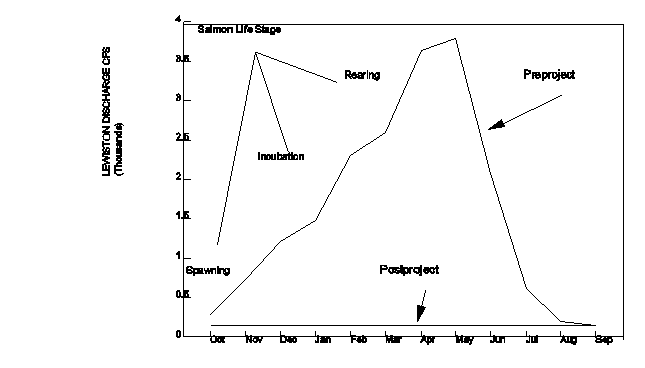 Figure III-1:. Pre and post-project mean monthly flow in the Trinity River at Lewiston. Note salmonid life history coincidence with streamflow. (from USFWS 1994).
![]()
![]()
Sediment berms covered with mature riparian vegetation line the channel for most of the 40 mile reach in the analysis area. The river is severely channelized and restricted by sediment berms, which have reduced the actual open water area by 45 percent and decreased the accessible gravel bar area by 95 percent. These changes in channel morphology and the loss of flow diversity and channel dynamics have had numerous impacts on aquatic and terrestrial habitats. Increased water velocity and depth and decreased channel width have reduced rearing and spawning habitat. The concurrent increases in riparian habitat are discussed in that issue. Recreational access is limited by the dense vegetation which lines the channel, a phenomenon which has had a positive impact on the local drift boat fishing guide industry. Figure III-2 shows the compositional change along the riparian corridor between 1960 and 1989. Sixteen color plates entitled "Trinity River Riparian Vegetation", graphically display conditions in 1960 and 1989.
FIGURE III-2. Comparison of riparian vegetation, gravel bar, and open water habitat between 1960 and 1989 in the upper Trinity River (Wilson1993).
![]()
![]()
Current water releases are of insufficient magnitude and duration to flush the sediment input from the tributaries or mobilize the streambed. Prior to dam construction, natural high flows resulting annually from storm runoff and spring snow melt flushed sediment through the main stem channel and mobilized the streambed, maintaining dynamic, high quality aquatic habitat. Figure III-3 compares sediment discharge from Grass Valley Creek versus the Trinity River at Limekiln Gulch, 12.7 miles downstream of Lewiston Dam.
The current flow regime does not mimic the natural flow regime under which the channel conditions and biologic community evolved. The seasonal variations in flow of the natural system shaped the conditions in the stream channel and influenced the timing and distribution of various life stage events of species dependent on habitat the river provides. Flow regulation, which varies considerably from the natural regime, has had negative impacts on those species and channel conditions under which those species evolved.
FIGURE III-3: Water and sediment discharge for the Trinity River and Grass Valley Creek: January-July 1983 (Wilcock, 1995)
![]()
![]()
The coarse channel substrate is embedded with sand. Under natural conditions, the channel substrate was mobilized by annual high stream flows and remained relatively free of sand, providing high quality habitat for the various life stages of anadromous salmonids and invertebrates. The currently degraded habitat and reduced source of invertebrates limits the productive capacity of the river. The recreational and commercial fishing industries have suffered economic losses due to fish population reductions resulting from habitat losses and other factors.
Urban development has encroached onto the 100 year flood plain since construction of the dams in 1960. Prior to construction this floodplain flooded at least every other year. Construction on the flood plain has created the potential for economic loss and public safety hazards during stream flows exceeding 6,000 cfs. Regulated flow has provided economic and aesthetic opportunities for a few people, but limits flow management which could benefit the fishery and a much larger segment of the public.
Numbers of chinook have declined overall since construction of Trinity and Lewiston dams, although there has been extensive variation in run size during this period. Spring chinook generally begin entering the basin, as they did historically, in late spring and early summer and begin spawning in early to mid- September. The fall run of chinook salmon is presently the dominant run (numerically) in the Trinity River. This run generally enters the analysis area during late summer or early autumn (September to October). They reach sexual maturation quickly and usually begin spawning in October. Although the spring run begins spawning earlier, there is some overlap of spawning activity between the two runs.
Presently, coho salmon and steelhead occur throughout the main stem as well as in may of the tributaries. Coho enter the analysis area during fall and spawn from late fall to early winter. Steelhead enter the basin during several months of the year and most spawning in the analysis area occurs in early winter. Steelhead populations have continued to decline for several years in the Trinity basin even though they have been protected from commercial harvest for several years. The life cycle of steelhead trout, coho and chinook salmon is presented in Table III-1. Summer Steelhead trout runs have been recorded from the North Fork Trinity River, New River (tributary to the Trinity), South Fork Trinity River, and Canyon Creek.
|
Fish Species or Run |
Steelhead Trout (Summer Run) |
Coho |
Chinook Spring-Run |
Chinook Fall-Run |
|
Principal Months Adults migrate into fresh water to spawn |
August through March; peak Oct-Nov (April-June) |
Early September through January. |
April through October. |
August through December |
|
Principal Spawning Months |
February through April. (Dec-April) |
November through January. |
September through October. |
October through January. Peaks in November. |
|
Eggs in gravel, time related to water temperature |
80 Days at 40F incubation |
1-3 months |
3-4 month incubation |
3-4 month incubation |
|
Alevins in Gravel |
2-3 weeks |
4-10 weeks |
2-3 weeks |
2-3 weeks |
|
Max period in gravel |
February through late July (Dec. through late Aug.) |
November through mid-May. |
Late September through late February. |
October through late March. |
|
Length of time fry stay in fresh water |
1-2 years, majority at 2 years (1-3 years) |
1 year 10-13 cm |
About six months, move to estuary in October-December or first rains. |
About six months, move to estuary in October- December |
|
Smolt migrate from freshwater to the sea |
end of March to early August |
end of February through mid-June; peaking in April. |
April - June .& Oct. Nov. |
April - June & Oct. - Nov. |
|
Length of ocean life |
1-3 years (3-5 years) |
1-3 years, most 2 years in the ocean (age 3 yrs) |
2-4 years, today most return after 2 years |
2-4 years, today most return after 2 years |
Table III-1:The Life Cycle of Trinity River Steelhead Trout, Coho and Chinook Salmon
![]()
![]()
The Trinity River hatchery was constructed in order to mitigate the loss of salmonids that were historically produced above the dam sites. Each year, the hatchery artifically spawns returning adult chinook and coho salmon and steelhead. Numbers or returning adults have varied widely with each species since the hatchery began operation. Returns of chinook salmon have ranged from 2,586 to 36,386: coho returns have ranged from 12 to 23,338, and steelhead returns have ranged from 13 to 6,941. Numbers of juveniles released from the hatchery have varied as well. Recent releases (1991-1995) for fall run chinook fingerling have ranged from 202,275 to 2,342,037; spring run fingerling releases have ranged from 828,406 to 1,498,015. For the same time period, coho and steelhead yearling releases have ranged from 384,555 to 627,739 and 323,791 to 1,158,171 respectively.
Fish habitat in the analysis area is limited by reduced flows and the physical condition of the Trinity River and its tributaries. Historical spawning beds composed of clean gravel and cobble have become embedded with fine sediment deposits. Access to shallow water rearing habitat once abundant on gravel bars is blocked or buried by sediment berms which line both sides of the river and by the loss of gravel recruitment resulting from the dams. The habitat losses resulting from the sedimentation of the river channel have reduced the reproductive carrying capacity of this portion of the Trinity River. Table III-2 displays habitat types and their importance to fish life stages.
|
Habitat |
Importance |
Critical Time-frame |
|
Shallow water along stream or river margins. |
After salmon fry emerge from gravel they require slow water habitat in order to avoid being washed downstream and avoid being eaten by larger fish. This habitat is very important energy (food) production site. Shallow water is the most productive area in an aquatic ecosystem and it produces the insects that are the size young fish can eat. |
December through August |
|
In Tributaries - Deep (1 + m) well shaded pools. Best with large amounts of woody debris. |
As fry grow bigger they soon set up individual territories in pool areas. The larger ones tend to occupy the heads of pools; the smaller ones are found further down the pools. These pools are critical holding areas for summer-run steelhead and spring-run chinook. |
All year |
|
River run habitats with large cobble substrates without excessive sedimentation. |
Juvenile steelhead rely on clean large cobble substrates for cover habitat during the winter. Excessive sedimentation in the main stem Trinity River has nearly eliminated these cobble habitat areas. Chinook juveniles also require this cobble habitat because it provides water velocity shelters. |
July - March |
|
Beds of loose coarse spawning gravel at the heads of riffles or tails of pools with cover nearby for adults. With less than 25 percent fines, depths of 20-120 cm, and mean water-column velocities of 20-40 cm/sec-1. Steelhead gravel range from 0.64 to 13 cm. Chinook and coho gravel range from 5 to 15 cm in diameter |
Steelhead, coho, and chinook require clean, cool water over gravel for successful spawning and egg incubation. The construction of the Lewistown dam has closed 109 miles of spawning habitat and reduced flow in the main stem Trinity which limits its ability to flush sediment. |
September through July |
Table III-2: Important Steelhead and Salmon Habitat that is Limited in the Trinity River Basin and the Time-frame the Habitat is Most Critical.
![]()
![]()
Trinity and Lewiston dams are migration barriers which block salmon and steelhead from 109 miles of suitable reproductive habitat. The loss of this habitat has contributed to the reduction of fish numbers. Spring chinook which historically "summered-over" in deep pools between Lewiston and Stuarts Fork are now limited to pools below Lewiston which have partially filled with sediment. Summer releases from Lewiston reservoir are artificially higher than historic levels in order to provide cool water for the spring chinook adults.
Introduced fish species include brown trout, brook trout, and three-spine stickleback. The effects of introduced species have not been thoroughly studied in the Trinity basin. Brown trout compete directly for food and cover with all native salmonids in the river. Brown trout become territorial and larger fish tend to dominate areas of suitable habitat. Direct mortality results from brown trout preying on juveniles of other species including salmon and steelhead.
Mining on the main stem Trinity River produced changes in the landscape that are still visible today and influence the distribution of wildlife. Hydraulic mining in the late 1800's and early 1900's produced lasting alterations from excavation of entire hillsides. Mining tunnels currently provide cover for terrestrial species, such as bats, which roost and overwinter in the shafts. Dredge mining in the mid 1900's created terrace pools some of which harbor western pond turtles and/or migratory fowl. These ponds may also facilitate the spread of non-native bullfrogs, which inhabit lentic waters.
Acres of riparian vegetation along the main stem Trinity River increased by 282 percent between 1960 and 1989 as an indirect result of the dams. The regulated stream flow prevents the removal of young riparian plants that historically would have been removed from gravel bars by high winter flows. Also, riparian seedlings receive year-round irrigation, in contrast to natural conditions of summer desiccation. The combined result is the establishment and maintenance of willows and alder in later seral stages, with the accompanying loss of open water and gravel bar habitats. These changes in the distribution of riparian vegetation have a wide range of effects on wildlife species. Riparian-dependent birds and mammals, such as the willow flycatcher and muskrat, are likely to have increased in number. Other species that require shallow edgewater habitats, such as wading birds and yellow-legged frogs, are likely to have decreased.
The Trinity River has also changed structurally as a result of the dams. Whereas winter flooding flows used to wash woody debris and sediment downstream, they now accumulate in slow-flowing areas. Piles of woody debris provide cover for numerous species, including salmonids, western pond turtles, and beavers. However, accumulated sediment fills pools, resulting in the loss of deep, cool-water refuges for fishes and turtles. Below the confluence with Grass Valley Creek, sediment buildup is particularly acute, and the composition of aquatic invertebrate populations appears altered. Coarse sand fills the interstitial spaces of gravel and cobble substrates, which are the sites of invertebrate production. Because invertebrates form the base of the riverine food chain, such alterations can have ramifications throughout the system.
To mitigate for the dams' preclusion of annual flooding flows and elimination of fish habitat, a program of artificially high flows was instituted. The timing of these flows, to the degree that it varies from natural conditions, has impacted amphibians and reptiles. Frog egg masses deposited during the spring were washed downstream by subsequent flow boosts (Lind 1992). Artificial flows also generate lower water temperatures during the summer months than under natural conditions. Ectothermic ("cold-blooded") wildlife species respond to temperature changes. For example, juvenile steelhead and coho salmon are likely to grow more slowly, as are amphibian and aquatic reptile larvae. Cool waters might retard egg development and/or delay metamorphosis of amphibians with consequent impacts on reproductive success.
Efforts to restore the main stem Trinity River with respect to spawning salmonids have included mechanical manipulations of the channel. The side channels and feathered edges, which mimic the conditions available prior to the dams, incidently provide habitat for wildlife that utilize shallow edgewaters. These include yellow-legged frogs, which have deposited eggs in the manipulated sites, as well as hatchling western pond turtles, which occupy slow-flow habitats. The manipulations may also provide foraging areas for wading birds and semi-aquatic mammals.
Overall, conditions have become more stagnant in the main stem Trinity due to disruption of the natural processes that renew habitat. Bar migration is restricted, vegetation scour moderated, and sediment transport reduced. The long-term consequence may be lowered spatial and temporal diversity of habitats. Wildlife diversity may decline as particular habitats, such as unvegetated gravel bars, become scarce.
Geology and soils interact with vegetation, climate, various land disturbances and stream channel sediment transport characteristics to produce sediment. Highly erosive granitic soils constitute 17 percent of the analysis area and are distributed over eight tributaries. Estimates indicate that these areas produce 72 percent of the sediment reaching the Trinity main stem. Figure III-4 displays the sources of sediment. Land use activities which modify drainage patterns or remove vegetative cover in these highly erosive areas can greatly accelerate erosion and sedimentation. Efforts to curb sediment production and delivery are concentrated in these geographic areas.
FIGURE III-4: Estimate of Sediment Contributions from Significant Sediment-Producing Tributaries.
![]()
![]()
Granitic sediment produces the size fraction which is most detrimental to the aquatic habitat in the Trinity river. Granitic soils contain a high percentage of sand, a sediment which becomes embedded in the river bed, destroying aquatic habitat. It is the major particle constituent of the sediment berms deposited on natural gravel bars along the river. Non-granitic soils dominantly have very gravelly loam and very gravelly clay loam soil textures, which produce a bimodal distribution of sediment. The fine size sediment component remains suspended and is transported down the river. The coarse size sediment component constitutes the gravel fraction which is beneficial to the aquatic ecosystem. This coarse sediment is currently in deficit, an indirect result of the Lewiston and Trinity dams.
Two tributaries, Grass Valley Creek (GVC) and Canyon Creek constitute 65 percent of the granitic areas. Land management in GVC has undergone drastic changes in the last few years. Since 1993 GVC has been dominantly publicly owned and managed for erosion and sediment control rather than timber production. Granitic soils in the Canyon Creek watershed are publicly owned, are managed as wilderness area, have few roads and consequently experience low erosion rates considering the high erosion hazard. Erosion control activities in GVC have reduced the long term sediment production capacity by about 50 percent and land management goals have changed from timber production to erosion and sediment reduction. These measures should gradually reduce erosion to the natural range of variability.
Vegetation in the analysis area consists of coniferous and hardwood forests, montane chaparral and riparian. Large, severe wildfire events destroy vegetation and leave the soil susceptible to severe erosion. Erosion following fire can produce large sediment influxes to the tributary streams which may be transported and deposited in the main stem Trinity River.
The suppression of wildfire has resulted in the buildup of fuel throughout the analysis area and has increased the potential for large scale fires, which burn with greater intensity than under "natural"
conditions and generally result in greater resource damage. Large scale watershed disturbance such as wildfire can result in soil hydrophobicity, loss of vegetative cover, increased runoff and severe erosion and sediment production, which may damage aquatic habitat.
Current land use activities which constitute the greatest sedimentation hazards are logging and the transportation network. Logging disturbs the natural equilibrium by removing vegetative cover and altering the natural drainage pattern through road construction. Logging practices which minimize the impacts of these phenomena, such as helicopter yarding and retention of the maximum vegetative cover practical, can reduce erosion and sedimentation resulting from this land use. Transportation network design, location and maintenance can reduce the sediment production and delivery. The logging and wood processing industry is a major employer in the area.
Land use in the Trinity River watershed continues to be limited by the mountainous terrain and dispersed ownership of the land. With much of the land in forests and publicly owned, logging remains an important use. Other major uses of the land in the watershed are recreation, housing, mining and road networks. Along the Trinity River, private property ownership and development has increased. All of these land uses have resulted in ecological and economic impacts within the watershed and have helped shape human values and expectations.
Logging, conducted extensively throughout the tributaries except Canyon Creek, has significantly modified natural conditions. Most of the forested areas have been cut at least once and many areas twice. Logging intensified as technologies improved and roads were constructed in unstable locations, increasing natural erosion rates. Certain logging practices such as tractor logging and poor road construction may increase erosion and sedimentation, alter runoff characteristics and destroy aquatic and terrestrial wildlife habitat. The decline in logging in recent years has negatively affected the economy of the area, as this community has been resource-dependent. Figure III-5 illustrates the declining trend of timber harvest volume in Trinity County.
Figure III-5: Timber harvest volume in Trinity County between 1948 and 1994.
![]()
![]()
Recreational fishing is important on the main stem and many tributaries. The economic value of sport fishing is significant and provides employment to many residents and recreation for visitors, and benefits the owners of resorts, motels and restaurants. This industry is dependent on a healthy productive fishery, and the decline of the fishery has negatively affected these businesses.
Water sports, such as rafting and boating, occur on the main stem during the summer months. Water sports draw needed tourism dollars and are dependent on clean water and adequate stream flow during the summer. Attractive scenery along the stream corridor is important to these river users as well. Camping and hiking uses occur on the main stem and in tributaries and are dependent on maintenance of high visual quality. Maintained trails and camps attract visitors to this area because of the beauty, relative remoteness and uncrowded atmosphere. Recreation is economically significant in this area.
Water diversions for local consumption occur on the main stem and many tributaries. Local water diversions meet residential water needs and are dependent on clean abundant supplies. This activity has minor impacts basinwide except in Weaver Creek, where diversion greatly reduces the late summer flows between Weaverville and the Trinity River, reducing the habitat and productivity of the Weaver Creek fishery.
The Trinity Division of the CVP diverts and exports an average 800,000 to 1,000,000 acre feet/year to the Central Valley Project. Water export for agricultural consumption, urban uses and power generation supports a multimillion dollar industry and provides employment for thousands of people living in the California's Central Valley. These water diversions have initiated huge changes in the main stem ecology, resulting in detrimental effects on many habitats and enhancement of those dependent upon late seral riparian vegetation.
Mining occurs in the main stem and Canyon Creek as suction dredging and in a few tributary watersheds as placer mining. Most of the historically productive commercial mines are now idle, but have had considerable impact on the watershed in the past. Mining activities provide part- and full time employment for a few residents and recreational opportunities for tourists. Mining can have a negative impact on the fish habitat if conducted in the wrong location or at the wrong time of year.
Regulations have affected land use practices and are a result of human values as impacts of certain practices have become recognized. Mining regulations attempt to mitigate for the problems mentioned above, while regulations associated with timber harvests are attempts at protecting what is considered valuable to society, such as endangered species. The regulations currently in place are due in large part to increased awareness of environmental concerns facing society. Regulations have become more stringent over times which has resulted in reductions in resource extractions. However, the increased amount of regulations aimed at protecting resources has created conflict in a community that is so vitally resource-dependent. The impact of these regulations are felt significantly since the job market is often reduced as a result and unemployment is already very high for the area compared to the rest of the state. Figure III-6 compares the unemployment rate in Trinity County to that of California between 1983 and 1994.
Figure III-6: Unemployment rates in California and Trinity County between 1983 and 1994
![]()
![]()
Residential development in the floodplain of the main stem Trinity River in several small areas has occurred and benefits a small number of citizens. This encroachment limits the magnitude of beneficial stream flow releases. During stream flow releases exceeding 6,500 cfs, flooding of homes, structures, some bridges and roads occurs. This could be a limitation on the amount of increased flows allowable for fisheries enhancement. Further encroachment onto the Trinity River 100-year post-dam flood plain (8500cfs) is no longer allowed.
A transportation network of paved and unpaved roads traverses most tributaries and the main stem corridor. The transportation network which is essential to human interests creates erosion, sedimentation and stream course diversions, which negatively impact ecological conditions in the stream corridors and species dependent upon those habitats. As the population increases and new homes are constructed, road building for access tends to occur as well. People value the ability to drive to places for hunting, hiking, residential and industrial needs. These benefical uses are in conflict with the potential damage roads have on the ecosystem, due to erosion.
Traditional Native American lifestyle in the Trinity River Basin was inextricably tied to the river ecology that preceded the dam. The native land use practices and the river's yearly flooding created a healthy dynamic environment which was the source of most of their needs and was significant to their spiritual and cultural well-being. Currently, the changes that exist because of the dam, current land uses, and population densities define a totally different kind of interaction by the native people with their environment. Some native people in the watershed continue their traditional gathering of fish and plants for ceremony and subsistence though the conditions are less than ideal for such practices.
The traditional native use of fire to enhance the health of the environment has been regulated to date and has contributed to the change in the structure and age of the forest. There are less young shoots growing on the willow and filbert bushes, which are essential to native basket making. There is also less young growth in the understory of the forests and less native perennial bunch grass species. All of these changes relate to the health of the riparian ecosystem and the degree to which the native people can carry on their traditional lifestyle.
River restoration projects including feather edges and side channels have been implemented on the main stem of the Trinity River in an effort to create or improve fish habitat. Temporary high levels of turbidity in limited reaches of the river resulting from these projects caused concern among users of the river amd affected other river uses.
Recreation-based tourism is becoming increasingly important to the communities as the decline in timber production and other resource extraction continues. The economic benefit is significant to this low income community. This industry requires adequate stream flow and a healthy fishery, and high visual and aesthetic quality. At the same time, a road network for people to access these areas is necessary.
To place the issues in context of the history of the analysis area, the last 145 years have been broken out into eras: pre-european (before 1850), mining (1850-1945), logging (1946-1960), and post-dam (1961 to present). All the issues are framed within these eras so that linkages between reference and current conditions are revealed. Each era describes the six watershed analysis issues and their relationship with each other. Issues five and six (Land Us and Human Values) have been combined due to their similarity.
The Trinity was still a "wild" river and its flow was uncontrolled. The channel conditions were sculpted by climatic conditions which varied annually and over time. Climatic shifts resulting in wetter or drier moisture regimes were accompanied by adjustments in size and shape and, perhaps, bed elevation of the channel.
From 50 years of record between 1912 and 1960 flow conditions for the past 100 years may be assumed. Annual discharge was approximately 1.2 million acre feet per year at Lewiston. Instantaneous peak discharge reached approximately 18,500 cfs every two years, and the peak recorded during the period of record is 71,600 cfs, in 1955.
The annual hydrograph peaked during the winter months due to storm runoff and during the spring months due to snow melt runoff. These high flows scoured vegetation from the floodplain, preventing establishment of large areas of mature riparian vegetation and encouraging early seral stages of vegetation. As the snowmelt runoff subsided and the stream channel receded, low summer flows resulted in warmer water temperatures and desiccation of seedlings which germinated during the late spring and early summer. The seasonal high flows maintained deep pools, scoured the vegetation emerging on the floodplain, mobilized sediment, and built or maintained an alternate bar channel morphology in the predominantly "alluvial" river channel system.
The Trinity River likely resembled other large anadromous fish rivers, with alternating point bars of cobble and gravel on the inside bend of the river. The channel was much wider and deeper with cool, deep pools, riffles composed of relatively coarse gravel, and intermittent runs with flows of moderate velocity. The Trinity River supported anadromous populations of coho, chinook, steelhead and Pacific lamprey. Green sturgeon were also present in the lower Trinity River and were reported in the South Fork. Non-anadromous species included rainbow trout, speckled dace and suckers.
Every one an a half to two years, flows greater than 6,000 cfs would occur at Lewiston for several days at a time during spring every few years. These types of flows had major impacts on channel and floodplain morphology and ecology by maintaining the deep pools required by oversummering adult salmonids. These deep pools would have also benefitted juveniles that remained in the river for extended periods.
Floods and low flows generally had beneficial effects on fisheries. Floods helped maintain habitat diversity, while low flows allowed for recolonization by macroinvertebrates that are the primary food source for juveniles. Adult spawning migrations were triggered by changes in flows, along with other seasonal factors.
The temperature regime in the river was lower in the winter and higher during the low flow periods of summer and early fall. The transition periods during the months of May and November were similar to present temperatures. Juvenile chinook outmigration patterns were probably triggered by the temperature and flow changes that occurred in the river.
Historical information on the role of tributaries in fisheries is very limited, although they were undoubtedly very important for steelhead. This species usually seeks smaller streams and areas far upstream for spawning. Some of the larger tributaries would have provided adequate spawning and rearing habitat for chinook and possibly, coho salmon.
Some data exists regarding the abundance and distribution of riparian wildlife habitat prior to European settlement (Table IV-1). However, the relative abundance of most species must be inferred from knowledge of their life history requirements in relation to the changes that have occurred on the mainstem. The distribution of riparian species is associated with the distribution of riparian vegetation. Assuming that pre-dam assessments of riparian vegetation are a good proxy for the conditions prior to European settlement, we can make inferences about wildlife distributions.
Comparison of aerial photographs from 1960 (pre-dam) and 1989 (post-dam) reveals that gravel bars used to be much more extensive and that riparian vegetation was dominated by young willows. Early seral stage vegetation was maintained by dynamic flow regime that regularly mobilized and reorganized the river substrate. Species found in association with mature riparian vegetation, such as willow flycatchers, various neotropical warblers, yellow-breasted chats, and rufous-sided towhees, were presumably less abundant. The species composition of fish-eating bird populations may have depended upon their foraging strategies. Species that forage from shaded perches or snags, such as green-backed herons and belted kingfishers, were probably more scarce, while species that utilize open gravel bars with slow-flowing water, such as great blue herons, were probably more common.
|
Year |
Open water |
Gravel bar |
Willow dom (early-seral) |
Will/Alder (mid-seral) |
Alder (late-seral)) |
|
1960 |
601 |
752/71% |
239/22% |
67/6% |
7/1% |
|
1989 |
393 |
41/4% |
326/36% |
382/41% |
173/19% |
Table IV-1: Comparison of Riparian Vegetation Distributions, 1960 vs. 1989, ac/% of riparian zone
![]()
![]()
Equivalent relationships between the historic distribution of riparian habitat and riparian-dependent species can be described for mammals and herpetofauna. For example, minks, shrews, and other small mammals are likely to have benefitted from the increase in riparian vegetation along the riverbanks. Western toads and Pacific treefrogs, which are associated with gravel bar habitats, may have suffered.
Sediment was produced largely as a result of natural processes. Geologic erosion produced sediment as a result of uplift, landslides, streambank scour, sheet and rill erosion of landform surfaces. Natural disturbances to the vegetative cover such as fire or insect mortality temporarily reduced the surface soil cover and increased the erosion rates. Large storm events produced runoff, erosion, and sediment transport. The sediment mobilized by these events was transported through the system by high stream flows.
Archaeological evidence on South Fork Mountain indicates human occupation of Trinity County dating back some 8,000 years. When the climate shifted and became more maritime 3,800 or 2,300 YBP, upland resources diminished, which had been favored by native people during more mediterranean climates. The presence of more permanent settlements adjacent to the river reflect a strong reliance on the riverine ecosystem during this time. Two tribes, the Chimariko and the Wintu, occupied the watershed. The Chimariko occupied the lower watershed up to Helena, or perhaps as far as Junction City, while the Wintu lived all long the river from above Trinity Dam downstream to Junction City. Their social structures were variable, from centralized villages with a "headman", to small, self-governing tribelets, but they were part of the Northwest salmon culture and their subsistence relied on the salmon for their main source of meat. Acorns from adjacent oak woodlands became the main source of plant food. Upland areas were still used to gather food and to hunt. The salmon were caught using weirs, traps, dip nets, spears, clubs, fish drives, or salmon house that projected poles over the river. The fish were prepared, preserved, and stored using many techniques. Their diets were supplemented by elk, deer, bear, small mammals, birds, and a variety of available wild plant foods, including many associated with a riverine environment. These included blackberries, willows, maidenhair fern and bear grass.
Native Americans used fire to increase wildlife habitat diversity and to increase the "edge effect" (the open space/woodland interface) as well (Barrett 1980). Burning served to rid an area of unwanted insects and disease, encouraged berry production, and cleared ground under oak trees to enhance a acorn collection. Fires also encouraged new growth of plant species that were used in basketry as well as attracting foraging ungulates. These indigenous peoples presumable maintained a peaceful existence of relative abundance in the watershed for thousands of years.
With the discovery of gold on the Trinity River in 1848, placer mining became widespread along the Trinity and in many of the tributary streams. It was reported that by the spring of 1852, every gravel bar along the Trinity, from Salyer to Carrville, and every tributary leading into the Trinity had been traversed or prospected. Periodic flooding in 1861-62 and again in 1888-89 destroyed bridges and mining camps built in the Trinity floodplain effectively demonstrating that the Trinity was still a wild river.
Hydraulic mining introduced large volumes of sediment to the channel. As part of the search for gold, tributary flows were diverted to wash hillsides into the Trinity. La Grange mine in Oregon Gulch resulted in the movement of 100 million yards of material. During the peak of hydraulic mining, 71 mines operated in Trinity County. Most of this material ended up in the stream channels, resulting in altered channel morphology and diminished spawning habitat, and it contributed to reductions in salmonid population (Sherbourne Cook).
Dredging of the Trinity alluvial channel followed placer and hydraulic mining and resulted in dam construction and re-routing of the channel in order to mine the channel bed. Even though the magnitude of these impacts on channel morphology and its dependent fisheries was tremendous, the fishery resource rebounded and was estimated to produce 900,000 pounds of fish per year between 1916 and 1943.
The disturbances of quaternary alluvial deposits in the tributaries resulted in contributions of significant sediment amounts to the mainstem for several decades following the mining era. Along the mainstem, dredging of alluvial deposits drastically altered the channel morphology during and for several years following the disturbance. However, periodic high stream discharge events which continued until construction of the Trinity and Lewiston dams, acted to restore the historic channel morphology and natural function of the mainstem channel. Evidence from aerial photographs from 1944 shows the lack of vegetation on tailing piles, an indication that restoration of natural conditions on river terraces was not occurring.
During this era (and probably prior to European settlement), and up until the dams were constructed, almost the entire length of the Trinity River was used by anadromous fish. The earliest spring run chinook would migrate past Lewiston during June and July, and find deep pools to hold in between Lewiston and Trinity Center later in the summer. Spring chinook historically "summered over" in deep pools between Lewiston and Stuart's Fork. Spawning fish were seen in early October between Grass Valley Creek and the Stuart's Fork. Later in the month, spawners would be scattered from the North Fork to the East Fork, about 65 miles upstream. Migrations of adult fall chinook usually coincided with the first fall rains and subsequent increased river flows, with the fish reaching Lewiston in early October. The actual timing of migration and spawning after dam construction has remained similar to historic trends.
The spring chinook race may have comprised the largest run of chinook entering the Trinity River before gold miners arrived in 1850. Snyder (1931) cites an undated paper by R.D. Hume claiming this as a fact, which is logical given the characteristics of the river system and its potential fish habitat. Hume's paper, presumed to have been written around 1900, already declared the Trinity River spring chinook race as nearly extinct by 1892. This could very well be true, given the intensive mining that took place, beginning in the 1860's through the early part of this century. Actual numbers of fish are almost non-existent and only anecdotal information is available. Other fish species included brown and brook trout, which was introduced into the Trinity River in the late 1800's, and steelhead, though they preferred tributary habitat.
Undoubtedly, there were long lasting impacts to spawning, rearing and associated habitat as a result of mining activities. Millions of yards of material were moved out of the active channel; much of that material, which would have provided high quality spawning and rearing habitat, remains out of the channel today. However, the natural river dynamic was continually reestablishing itself, providing flows and temperatures that were conducive to spawning habitat.
Farms and ranches probably had temporary effects on water quality, due to streambank erosion and cattle waste in the water, but agriculture was not a major land use below Lewiston. Direct effects of agriculture on the fisheries populations and habitat would not have been significant.
Historical information on the role of tributaries in fisheries is very limited, though they were important for steelhead, as the species usually seeks smaller streams and areas far upstream for spawning. There is almost no information on tributary use by salmon between the North Fork and Lewiston prior to the dams. Mining activity in tributaries also had temporary effects on aquatic habitat, through water diversions and placer mining activities.
The mainstem Trinity River harbors a long history of mining activity with associated impacts on wildlife. Early placer mining produced widespread but temporary disruptions of gravel bar substrates, while hydraulic mining produced lasting alterations from excavation of entire hillsides. Large areas of riparian and upland habitat were removed. Short-term effects of placer mining undoubtedly included direct mortality of riparian species, including amphibian eggs and larvae associated with gravel bars. Hydraulic mining instigated severe sedimentation, that further degraded the suitability of gravel bars as rearing habitats for aquatic insects, amphibians, and fishes. Aquatic species that forage by sight, such as western pond turtles and river otters, were potentially impaired by river turbidity, and under water cover was eliminated as crevices were filled with sediment. The overall result was simplification of habitat with loss of diversity in depth and underwater structure.
During the mining era, localized logging reduced the density of conifers adjacent to the river. Perching species, such as osprey and bald eagle, may have been impacted, as well as species that require dense forest canopies (eg. goshawks, spotted owls). Long-term declines on recruitment of large woody debris into the river may have occurred as a result of source reduction. Coarse woody debris has been shown to be important for the functioning of stream ecosystems by providing cover, contributing nutrients, and generating pooled habitat. Salmonids, western ponds turtle, and semi-aquatic mammals have associations with woody debris.
Thus, impacts to riparian and aquatic wildlife habitats during the mining era were dramatic and are still visible on the landscape today. However, the riparian and fluvial processes were still at work, such that sediment transport and gravel bar migration could occur. In contrast, human activities during the era that followed not only altered the landscape, but also hampered the processes that permit recovery.
The discovery of gold altered the natural sediment balance in the river. Mining activities such as hydraulic mining, placer mining, logging for mine, flume and shelter lumber and road construction introduced massive amounts of sediment into the tributaries and the Trinity River. Hydraulic mining operations diverted streamflow into constructed ditches, using this water to wash millions of yards of gold bearing sedimentary deposits from terraces and hillsides into adjacent streams. This activity reduced natural streamflow at the diversion points and choked stream channels with sediment, temporarily altering aquatic habitat conditions.
The demand for lumber to support mining activities spawned localized logging activities of limited geographic extent. Photographic evidence of the hillsides adjacent to mining areas and communities document the "clearcut" nature of this timber harvest activity, which undoubtedly increased erosion and sedimentation. However, the primitive transportation system limited the total acreage impacted to a small percentage of the analysis area.
European values emphasized resource extraction and landscape manipulation, in stark contrast with the indigenous people then occupying the Trinity River basin. In their quest for gold, and the need for appurtenant infrastructure, the European settlers claimed land that the Chimariko and Wintu had traditionally held. The Native Americans were killed, enslaved or moved to reservations.
The settlers established camps and small communities centered on gold mining, including Junction City, Weaverville, Douglas City and Lewiston. Trail systems were built to transport supplies in and out of the county. Small mills were set up in conjunction with the camps to supply lumber for mine shafts and sluices, buildings, wagons and bridge crossings. Farms were established on the broad river terraces, and they supplied food and other goods to the miners.
Generally, the establishment of towns, farms, ranches and roads during this period were for the express purpose of serving the thriving mining community. The original and enduring attraction of Trinity County, in particular the Trinity River, was the promise of gold. All other enterprises were subordinate to this industry.
The Timber Culture Act of 1873 was enacted to provide the private citizen with the opportunity to purchase large tracts of land and to increase the lumber supply. Prior to this Act, it was difficult for sawmill owners and others to acquire large holdings of timberland. With this new mechanism, an individual could receive 160 acres of land if one quarter of the acreage was planted in trees within four years.
As hydraulic mining wound down in the early 1900's, farming and ranching replaced these activities as going concerns in their own right. Small scale logging continued, but harvesting was still limited to sites that were easily accessed.
Transportation routes continued to be improved, and the Trinity National Forest was created in 1905. Timber gradually replaced gold mining as the dominant industry as WWII approached, and local economies became more dependent on this resource.
Following World War II, the market for lumber, combined with the introduction of tractor yarding, once again drastically altered the natural environment in the analysis area. The housing boom in the 1950's and 60's created a demand for lumber which changed the timber production economy from one of local consumption to an export market. The widespread use of track driven equipment to construct logging roads, skid trails and yard logs resulted in huge increases in the amount of land disturbance and the geographic distribution of this land use. Thousands of miles of roads and skids were constructed, often in close proximity to or within stream channels. Sediment production increased dramatically. California Department of Fish & Game stopped stocking fish in Grass Valley Creek in the 60's because of the destruction of aquatic habitat from sedimentation and the apparent inability of the department to remedy this problem.
The demand for export lumber resulted in the harvest of a much larger geographic area and on terrain highly susceptible to erosion. Sedimentation resulting from widespread land use disturbances followed by the 1964 floods is well documented by USGS. A bridge on the South Fork Trinity River was buried by 13 feet of sediment during the '64 storm. The second best spawning riffle on the Trinity River in the analysis area was completely covered with fine sediment transported in the '64 storm (need a reference here).
The disturbances of quaternary alluvial deposits in the tributaries resulted in contributions of significant amounts of sediment to the mainstem for several decades following the mining era. Along the mainstem, dredging of alluvial deposits drastically altered the channel morphology during and for several years following the disturbance. However, periodic high stream discharge events, which continued until construction of the Trinity and Lewiston dams, acted to restore the historic channel morphology and natural function of the mainstem channel.
Rainbow trout were an important sport fishery in the Trinity River during this time. In 1941, an estimated 389,900 rainbow trout were harvested by anglers in the river, though some of them may have been juvenile steelhead. Unpublished Fish and Game reports indicate that rainbow trout were stocked for several years in many tributaries of the Trinity. Fish species that were probably introduced into the river during this era was the three-spine stickleback. Brook and brown trout stocking in the basin continued into this era, though the brook trout were limited and usually occurred only in the upper Trinity and its tributaries. Brown trout are very territorial and compete directly with all native salmonids for food and cover.
Reports of spawning chinook salmon in Rush, Reading, Brown's and Canyon Creeks, as well as the North Fork Trinity, occurred in 1965 (LaFaunce). During investigation of the Trinity Basin in the 1940's, impoundments in the upper limits of Rush Creek and Browns Creek were suggested as possible means to increase salmon spawning capacity in these streams (Moffett and Smith 1950). These impoundments would have been used to store water, then provide adequate flows to recruit salmon into these streams during the spawning season. There usually was not adequate water in these tributaries for spawners until later in the fall or winter, when rains increased the flows. There were also suggestions to remove several artificial dams and diversions in Browns and Rush Creeks that restricted fish movement during low flow periods.
Other tributaries that were suggested as potential sites for storage reservoirs were the North Fork Trinity, Canyon Creek, and Indian Creek (Wales, J.H. 1950). This report also stated that these streams were little used by salmon at the time, and it would probably take special measures to get runs started.
Coho salmon were not known to migrate far up the mainstem during Moffet and Smith's investigations. There were no definite indications that they had ever migrated upriver as far as Lewiston. Fine-scaled Klamath River suckers were reported to be widely distributed throughout the Trinity drainage, and dace were even more abundant. The speckled dace was apparently the most numerous fish in the Trinity River drainage during surveys in the 1940's and inhabited all sections of the drainage except for the headwaters of some tributaries.
Typically, steelhead would enter the larger tributaries, such as North Fork, Browns Creek and Stuart Fork, following the first fall rain. Smaller tributaries were entered later in the year, usually by February, as streamflows increased and maintained a flow sufficient to insure adequate spawning conditions. Spawning in tributaries occurred mostly in gravel pockets between boulders; however, spawning in the few available large riffle areas was so dense that individual redds could not be discerned (Moffett and Smith 1950). Actual timing varied from year to year, depending on weather and river flow patterns.
Though chronic sources of sediment were created through intensive and widespread logging operations during this era, there is no indication that there were longterm depressive effects on fish populations, with estimates for the entire Klamath Basin persisting from 350,000 to half a million during the first 60 years of this century. This is true also of natural sediment-producing events, such as floods (see Paul's text re: 1955, 1964 flood events etc).
As mentioned, the logging of large geographic areas and the development of an extensive network of roads and skid trails disrupted natural drainage patterns and resulted in chronic sedimentation of the mainstem Trinity. Riparian wildlife was undoubtedly affected both via direct sedimentation of aquatic habitat and indirect decreases in the aquatic insect prey base, During this era, large areas of upland and riparian wildlife habitats were disturbed, leading to fragmentation of previously continuous forests. Secretive species, such as fishers and martens, may have been affected. In addition, canopy cover was reduced, eliminating the characteristic structure of older forests that dictates suitability for amphibians, northern spotted owls, and other species. Logging of large conifers may also have reduced the availability of sites for snag-nesting and cavity-nesting birds, such as bald eagles and goshawks. Substantial logging occurred in inner gorges, exposing tributaries to solar radiation and thereby eliminating microhabitats for species with thermal sensitivities. Tailed frogs, for example, are restricted to montane streams with low water temperatures; thus, their associations with habitat variables indicative of older forests (downed wood, ferns, etc.). The impacts of logging, overall, were widespread and significant. However, they were mitigated to some degree by the natural fluvial processes of the river, which were still intact.
The transformation from a gold mining-based economy to a timber-dependent economy was complete after WWII. In 1959, timber production peaked in Trinity County with a harvest of 439 million board feet (mmb). In the late 1950's, large blocks of land privately owned in tributaries to the Trinity were intensively logged. Production on US Forest Service-managed land was high as well. The preferred logging method was 'clearcutting', which meant that at least 70 percent of standing timber was cut. There were two primary reasons for this: the Forest Service' performance was based on production numbers and, on both federal and private lands, 70 percent or more of a unit cut meant the land would not be taxed for 40 years. Economic incentives combined to prefer clearcutting as the dominant method of logging.
Not only did machinery and equipment improvements allow larger and more remote areas to be accessed for logging, but public transportation routes were improved as well. In 1940's, state highway 299 was completed, and numerous county roads in the analysis area were also constructed. Population increases in the Trinity River basin, as in the rest of the county, were slow but steady (10-15 percent). The analysis area, however, experienced a sharp increase during dam construction, resulting in a 50 percent increase countywide in one year. The river basin became increasingly popular as a sport fishery and hunting area. Recreation was a small, but increasingly important component of the local economy during this era.
Flow regulation from the closing of Trinity and Lewiston Dams brought drastic changes to the channel and fluvial process. In November 1960, when year round flow was reduced to 150 cfs, channel response to flow regulation was swift and dramatic. Almost immediately, riparian vegetation established became established along the wetted perimeter of the nearly constant shoreline water level. The vegetation began to trap sediment such that berm formation, stream channelization, and gravel bar burial were initiated. Gone were the annual high flows which scoured vegetation, transported sediment, drove the constant migration of alternate bars and maintained a clean gravel and cobble substrate in the channel. Between 1960 and 1989, Wilson found that 95 percent of the open gravel bar areas had disappeared, total riparian vegetation increased by 282 percent, and open water habitat decreased by 45 percent.
Sediment transported by unregulated flows from tributaries, experiencing massive land use disturbance, was deposited in the Trinity, burying spawning habitat with hundreds of thousands of tons of sand. In December of 1964, about three years and 1 month after flow regulation began, a significant storm event occurred. The "100 year storm" and resulting floods of '64 mobilized millions of tons of sediment. Much of this sediment settled in the Trinity channel, carried there by Grass Valley Creek, Canyon Creek, Weaver Creek and other tributaries. Spawning beds were completely covered, sediment berms gained feet in elevation and large deltas formed at many tributary confluences.
The river conditions which developed after the closing of the Lewiston dam can be illustrated by the comparison of two similar and remarkable flood events. The flood of 1955 occurred after intensive logging of the watershed. The storm provided up to a 70,000 cfs flow in the Trinity at Lewiston. Enormous sediment loads contributed to the river system apparently did not damage river habitats over the remaining 35-40 miles of river to the confluence of the North Fork, though regular surveys were conducted. The flood of 1964 occurred after the closing of the dam. The new reservoir received a measured discharge of 110,000 cfs. The reservoir contained the entire storm event. Only 150 cfs was released at the base of the dam, in contrast to the 100,000 cfs which would have passed by the site two years earlier. The flooding tributaries flowed at unimpeded levels carrying huge sediment loads, which were deposited into the placid flows of the mainstem below the dam. Grass Valley Creek alone discharged an estimated one million cubic yards of coarse granitic sand bedload into the river. A white sand river bed downstream of Grass Valley Creek was noted after 1964 during spawning salmon surveys.
Sediment production and transport from tributaries, recently disturbed by "intensive" timber harvest activities, was increasing while the sediment transport capacity of the mainstem was nearly eliminated. Changes to the channel morphology were drastic and immediate. Several studies and inventories are published which document the accumulation of sediment within the channel, encroachment of vegetation on flood plains, and changes in channel morphology.
Sediment berms quickly became established on point bars and flood plains. The constant water level provided by the regulated 150 cfs "flat hydrograph" fostered the rapid establishment of dense riparian vegetation on the floodplain which formerly was scoured by annual spring runoff and desiccated by low flows in August and September. The vegetation trapped sediment during the infrequent high stream flows and further channelized the river, reducing channel width, increasing water velocity and water depth. The sediment berms eliminated aquatic habitat critical to juvenile salmonids while fine sediment buried coarse gravel deposits, destroying essential spawning habitat.
Dam closure immediately eliminated 109 miles of anadromous fish habitat. Concurrent with this loss was the 1964 flood event, which resulted in millions of tons of sediment being deposited by tributaries, with a mainstem now incapable of transporting this sediment.
Numbers of chinook have declined overall since dam closure, although there has been large variation in run size during this era. In general, both salmon and steelhead populations declined at a rapid rate after dam closure. Harvest records kept since 1978 for fall run chinook salmon show a high of 65,951 (grilse and adult) in 1986, with a low of 3,347 in 1991. The mean for this period is 17,313. A significant percentage of that number are hatchery fish, however. It has been estimated that 59 percent of in-river spawners for 1987 were of hatchery origin (Hamaker 1995). This is contrasted with a mean of 38,154 wild fish, with a range of 19,00 to 67,115, above the North Fork prior to the dam (Hamaker 1995).
The conspicuously white sand river bed downstream of GVC was noted after 1964 during salmon spawning surveys; it was also noted that during the late 1960's salmon shifted their emphasis to the area within two miles of the base of the dam and began to avoid the reach of river downstream of GVC (GVC WA 1995).
Spring chinook now had to "summer over" in whatever deep pools were available below Lewiston until the fall, when spawning begins. Flows below Lewiston since dam construction have not been adequate to move sediment contributed from tributaries out of the mainstem. Pools below Lewiston may become too warm for adult salmon during low flow periods. Releases from Lewiston reservoir are generally much lower in June and July than historical flows, but are now often held at artificially high levels during late summer in order to provide cool water for the spring chinook adults. As well, the holding habitat for spring/summer-run steelhead has been substantially reduced. The largest portion of the steelhead runs in the Trinity now consist of fall and winter fish.
Overall, 90 percent of the historic anadromous fish runs have been lost, primarily in the last four decades. The combined effects of the Trinity Dam (1963), increased fish resource harvest (1970's and early 1980's), increased logging activities (post WWII to present), flood events (1964, 1982) and recent drought have all contributed to the decline in mainstem and tributary anadromous fisheries. As part of the Trinity Dam mitigation effort, a fish hatchery was established in Lewiston and has been augmenting wild salmonid stocks with hatchery fish stocks. Fishery programs developed and initiated since enactment of the Trinity River Restoration Program (1984) have attempted to recreate suitable habitat and pre-dam river conditions for salmonid populations. These projects have only been in place for three years. Despite these efforts, anadromous fish populations continue to decline.
As a result of the flat hydrograph of the Trinity River and its severely limited ability to flush sediment through the system, sediments accumulated, filling the previously deep pools that are utilized by salmonids, western pond turtles, and other creatures requiring cool-water refuges. Mitigation measures include the release of cool water from the dam, which lowers the river temperature overall. The decreased temperature is likely to impact amphibians and reptiles, in that their metabolic rates are closely tied to ambient temperature. The smaller body size and roughened carapaces of turtles on the mainstem Trinity relative to those on the undammed South Fork may constitute evidence for poorer growth. The timing of flow releases has also impacted wildlife. High flows have been timed to mimic the historical late-spring snowmelt runoff period. In 1991, the majority of yellow-legged frog egg masses were washed away by these artificial flows. Although the flow timing resembled the historic scenario, it did not take into account the proximal cues, which change from year to year, and to which frogs respond.
Another effect of the dam was to decrease surface water along the mainstem by 45 percent, with consequent drying of side channels and shallow, edgewater habitats. The river contour overall became more trapezoidal, with a decrease in slow-flowing waters close to the margins. In addition to their value as rearing habitat for salmonids, these areas harbor hatchling western pond turtles and early life stages of yellow-legged frogs. With lowered water volume, flow conditions also became more homogeneous, with the natural alternation of riffles and pools replaced by continuous glides. This lowered diversity of aquatic habitats is likely to result in lower diversity of aquatic wildlife.
Associated with the dampening of winter flood flows, which had a scouring effect, was an expansion of riparian vegetation, which constituted only 29 percent of the riparian zone prior to the dam. Now, it had increased to 96 percent by 1988. While early-stage willow used to predominate, late-seral willow and alder assemblages are now common. These habitats favor riparian-dependent species, such as willow flycatchers and neotropical birds. Species that require open gravel bar habitat, such as yellow-legged frogs, are disfavored.
Though single year timber production peaked in 1959, logging was the mainstay of the economy of Trinity County through the 1980's. The county's lumber production in 1990 totaled 224.2 mmb, with a value of $59.4 million (CA State Board of Equalization 1995). Interestingly, total Trinity County timber harvest amounted to only 141.4 mmb for 1993, but timber market value was $66,775,000 (CA State Board of Equalization 1995). Perceived lumber scarcity has kept wood product prices high.
Prior to 1970, general forest practices were unregulated. The Z'berg-Negedley Act of 1973 (commonly known as the Forest Practice Act) was enacted and applied to private timberlands. Until then, logging roads were poorly engineered, constructed and maintained and were (and continue to be) the source of substantial amounts of sediment into streams (Klamath River Basin Fisheries Resource Plan 1985). Clearcutting continued to be the dominant method of tree harvesting, on both private and public lands. By 1977, 42 percent of the Trinity River watershed had been logged, with 26 percent of that as clearcut, and 16 percent harvested with selective cut methods (DWR 1980).
Mining during this era has been largely relegated to recreational use, though a minor upsurge in claims occurred during the inflationary times of the early 1980's. Most gold mining is now done with suction dredging in the streambed, though a large high bench placer mine is in operation on Forest Service land on Canyon Creek. Evidence of past mining methods are still in evidence throughout the analysis area mainstem, including numerous large mine tailings and altered landscapes adjacent to the river.
Agricultural activities declined during this period and there are now no working ranches or farms in the analysis area.
Interest in sport fishing on the Trinity continued to increase through the 1960's, '70's and '80's, even as fish runs were declining. At the same time, the commercial fishing industry developed more efficient methods of fish harvesting in the ocean, further increasing the pressure on this resource. Native American gill netting, coupled with intensive ocean harvesting and sport fishing and meteorological events(such as El Nino), continued to contribute to the declines in populations of anadromous fish in the river basin (VTN 1979).
Recreation-oriented businesses and services, both in the analysis area and along the shores of the newly created reservoir, continued to increase during this time. In 1984 the Trinity Alps Wilderness was created, adding to the scenic attractions of the river basin. Tourism now accounts for 50-75 percent of the summer business and about 25 percent of winter business (BOR 1986).
Fire suppression efforts have increased in the analysis area as it becomes more populated. There are four volunteer fire departments, CDF and US Forest Service equipment to respond to fires. The result is that fuels have accumulated all over the basin, increasing the risk of a catastrophic fire, as occurred in 1987. This approach is in sharp contrast to that of the pre-European era.
Because the dam now regulated the flow of the river, human encroachment onto the floodplain occurred, and continued until 1990, when the county prohibited construction within the 100 year floodplain of the Trinity. The existing encroachments now constrain the flow regime, thus limiting restoration possibilities.
A recreation-based economy (rafting, sport fishing, camping) has developed in the analysis area, with interest centered on high quality river water, for both domestic purposes and aesthetic reasons. High summer flows necessary for some recreation can conflict with restoration efforts to mimic a natural flow regime. Native American claims to fish harvest amounts and water levels for ceremonial purposes affect both the fishery and flow management regime.
This section builds upon the results of the analysis and the understanding of the interrelationships described in the previous sections. Restoration opportunities and management actions that would initiate an ecosystem recovery process are presented in this section. Each action is described in terms of the potential to move the system toward natural conditions. In addition, the physical, ecological and social constraints which may hinder each action are explored. Additional data necessary to prescribe treatments or understand ecosystem components or relationships is listed. Finally, a brief list of monitoring needs is included. Since many restoration efforts have already been completed the monitoring task is extensive.
A restoration program should seek to restore natural processes within current and "reasonable" constraints (reasonable means socially acceptable tradeoffs). The restoration philosophy embraced in this section can be explained as follows: if the natural processes are restored or steps are taken to re-initiate natural processes, then critical habitats and functions will follow and be self-maintaining. The success of such a restoration scenario requires a coordinated approach which includes some combination of the following:
I. Restore stream flows of sufficient magnitude and duration to initiate dynamic fluvial processes similar to those which existed prior to dam construction.
II. Remove a significant portion of the sediment berms which have accumulated in the stream channel as a result of flow regulation and water diversion. This action will greatly facilitate the effectiveness of item I.
III. Reduce the sediment supply originating from various tributary watersheds through erosion control actions and land management activities.
IV. Restore a fire regime which approximates the frequency and intensity of the natural regime.
The re-institution of flows adequate for maintenance of dynamic channel morphology and all the ecosystem benefits associated with it is identified as the highest priority restoration need. Two categories of restored flows are addressed as recommendations.
This recommendation assumes a completely restored hydrograph which would require the removal of the Trinity River Division of the CVP. The natural timing and magnitude of flows would be fully restored. The stream channel morphology would respond to the natural flow dynamics, resulting in substrate movement, sediment flushing, channel migration and riparian scour. Over time, channel geometry and aquatic and terrestrial habitat would resemble the natural conditions which existed before dam construction and flow diversion. Sediment berms would gradually disappear, riparian vegetation would be reduced and riverine habitat diversity would be restored for fish and for riparian and aquatic dependent wildlife species. This restoration option carries significant social and economic constraints which may make it unfeasible as a restoration scenario.
Lewiston Dam Outlet works: The existing outlet structures can not accommodate the high flow volumes associated with the natural hydrograph. Restoring the magnitude of natural flows implies the removal of the dam.
Floodplain encroachment: The regulation of flows since the closing of the Trinity River Division allowed the development of homesites, low bridges, and businesses within the historic floodplain. These structures occur between Lewiston and Junction City. Many of these structures would be flooded under a natural flow regime. The California Department of Water Resources is currently evaluating the potential structural damage which may occur under several flow release scenarios.
Sediment berm resistance: Theories vary regarding the establishment of berms in the floodplain and their resistance to flows. The berms are armored by extensive riparian vegetation development and resist erosion under moderate streamflow. High flows currently appear to accelerate berm aggradation (Wilcock 1995), indicating a possible need to mechanically remove berms even under a fully restored natural flow regime. It is not known whether fully restored flows would eventually overcome the resistance of the riparian vegetation and existing berms, resulting in gradual restoration of the natural channel morphology. McBain and Trush's experiments pulling mature alders adjacent to the channel indicated that 15,000 cfs approached the lower limit of flow capable of alder removal. Additional considerations revolve around the life cycle of alders in the riparian zone. Typically alders establish in relatively even-aged stands which complete their life cycles and begin to lose stand structure in approximately 30 years. Declining alder stands may provide an opportunity to initiate berm deterioration with flows only.
Thermal refugia: A natural flow regime includes late summer flows much lower than the current releases. In the short-term, until the natural channel morphology was completely re-established, the lack of deep pools would impose a biological constraint. Deep pools provide cool water refugia for riparian and aquatic wildlife as well as salmonids. These refugia are not currently available due to accumulation of sediment in pools. Thus, artificially low summer water temperature in the whole channel is currently maintained by augmenting summer flows with releases from the dam.
Species impacts: A natural flow regime would result in short-term impacts to species which have adapted to altered conditions. Relative to current conditions, a natural hydrograph includes higher flows during the snowmelt runoff period and lower flows during the late summer months. In the short term, the disturbance created by these changes in flow could disrupt the activities of resident species. For example, western pond turtles that have colonized lentic backwater areas since construction of the dam might suddenly be displaced by the invasion of fast-flowing waters. New lentic areas would be created under a natural flow regime, but there could be a lag-time before colonization occurred. In the long-term, species that benefited from the alterations in conditions as a result of the dam would suffer. For example, willow flycatchers, which are likely to have been scarce historically, have colonized the main stem Trinity River in response to the dam-related increase in acreage of mature riparian vegetation. Restoration of a natural flow regime would substantially diminish the acreage and potentially exclude willow flycatchers from this area
Contracts for water delivery through the CVP may limit the total amount of water which flows down the Trinity River. Power and agriculture revenues generated from the diversion of Trinity River water would diminish under this recommendation and present a formidable social barrier. Urban water users in the Sacramento Valley who consume CVP water would suffer if diversions were reduced or eliminated.
Fish and wildlife in the Sacramento Valley currently benefit as a result of Trinity River water diversion. Reduced water diversion, currently used for water quality enhancement and wetland habitat enhancement, may harm fish and wildlife in the Sacramento Valley.
Floodplain encroachment along the main stem Trinity River would only be a temporary problem, as the first unregulated flows resulting from a 10 year storm would eliminate encroachment.
Recreation opportunities that have become established on the reservoirs would be eliminated, negatively impacting the tourism industry. Summer river recreation would be altered but likely evolve and adjust to the re-establishment of the natural flow regime.
This restoration scenario envisions a flow regime which is less than the natural hydrograph in quantity, but similar in seasonal distribution, duration. and recurrence frequency. The reintroduction of "channel forming flows" that approximate the 1.5 year. one week duration recurrence interval flow, would mobilize substrate, flush sediment and initiate natural channel migration. Wilcock (1995) suggest that discharges in the range of 5000 to 6000 cfs provide the greatest efficiency for moving sand through the main stem Trinity River in the analysis area, while keeping gravel loss to a minimum. McBain and Trush (1995) suggest that flows of 8500 cfs are required for mobilization and limited migration of alternate bars and tributary delta deposits. Fogg describes the use of flow duration data presented in Table CMFP-2 on page VI-l-10 of this document to determine the flow magnitude and duration necessary to mimic natural events.
The channel morphology would respond and be controlled by these channel forming flows, the degree of response would vary depending on the magnitude, duration and frequency of flows. Fluvial processes would have the ability to maintain a channel which is smaller in scale than the natural channel but is ecologically functional. The flow regime would be compatible with the timing of life history requirements of fish, as well as with riparian and aquatic dependent species.
The flow hydrograph should contain variability based on annual and long-term climatic cycles such as drought/wet cycles. Flows within the reduced hydrograph would be calibrated based on indicators of these conditions. Such conditions may be determined by total inflow into Trinity reservoir or a variety of other potential indicators. Fogg describes the methodology for developing flow recommendations in Section VI- Channel Morphology/Fluvial Processes.
Sediment accumulation in the main stem has occurred as a result of main stem flows which are out of phase with tributary sediment inputs. High tributary flows transporting heavy sediment loads in the absence of correspondingly high main stem flows allow tributary sediment loads to be stored in the main stem Trinity River. High tributary inflow conditions must be offset with sufficient main stem flows to flush introduced sediment loads through the system. Sediment discharge functions developed in this watershed analysis (and elsewhere) should be useful for evaluating sediment-transport efficiency of the recommended flow scenarios.
Currently the riparian zone includes extensive riparian development on established sediment berms. This condition confines the natural pre-dam channel geometry from its historical configuration. In effect, a small river is attempting to reshape the channel of a much larger river. Low flows do not carry sufficient energy to reconfigure the channel and are confined by the late-seral riparian vegetation and the established sediment berms. High flows through the current channel geometry during periods of tributary sediment transport appears to accelerate berm aggradation (Wilcock 1995). It is not known whether fully restored flows would eventually overcome the resistance of the riparian vegetation and existing berms, thereby resulting in gradual restoration of the natural channel morphology.
Lewiston Dam outlet works: The existing outlet structures can not accommodate flow volumes high enough to mimic the entire range of the natural hydrograph. However, releases approximating the 1.5 year recurrence interval flow of approximately 6,000 cfs for seven days duration, are physically possible with the current maximum release capability of 8,400 cfs. -
Floodplain encroachment: The regulation of flows since the construction of the Trinity River Division allowed the development of homesites, low bridges, and businesses within the historic floodplain. These structures which occur between Lewiston and Junction City, begin to flood at releases of about 6,500 cfs.
Thermal diversity: A dynamic river system frequently reorganizes the substrate, establishing meanders and alternate point bars, sorting gravels, and scouring pools. These processes provide a diversity of habitats for fish and for riparian and aquatic wildlife species. Under natural conditions, shallow, quiet, and warm water areas were available during high flows, and deep, cool habitats are available during summer low flows. Reinstituting a full range of flow diversity under current conditions may result in the exceedence of biological thresholds for certain species.
A flow regime which mimics the natural hydrograph would include summer flows much lower than the current releases. Under a natural flow regime, low summer flows played a critical role retarding the annual establishment of riparian seedlings. Seed germination and seedling survival is reduced when the floodplain watertable drops below the root zone and the wetted channel perimeter recedes from high water lines. Conversely, artificially high summer flows provide constant irrigation for young plants, aiding establishment and colonization of open gravel bar habitat.
In the short-term, until a channel geometry based on lower flows has established, the lack of deep pools imposes a biological constraint. Deep pools provide cool water refugia for riparian and aquatic wildlife as well as salmonids. These refugia are not currently available due to accumulation of sediment in pools. Summer water temperature standards are currently maintained by augmenting summer flows with releases from the dam. Such flows may need to continue in order to meet water quality standards for salmonids in particular.
Species impacts: A mimicked natural flow regime could result in both short and long-term impacts to species which have adapted to altered conditions. Relative to current conditions, a natural hydrograph includes higher flows during the snowmelt runoff period and lower flows during the summer months. In the short-term, the disturbance created by these changes in flow could disrupt the activities of resident species. For example, western pond turtles that have colonized lentic backwater areas since construction of the dam might suddenly be displaced by the invasion of fast-flowing waters. New lentic areas would be created under a natural flow regime, but there could be a lag-time before colonization occurred. In the long-term, species that benefited from the alterations in conditions as a result of the dam would suffer. For example, willow flycatchers, which are likely to have been scarce historically, have colonized the main stem Trinity in response to the dam-related increase in acreage of mature riparian vegetation. Restoration of a natural flow regime would substantially diminish the acreage and potentially exclude willow flycatchers from this area
The diversion of Trinity River water to the Sacramento and San Joaquin valleys provides numerous benefits to those regions. Any changes in the water diversion policies affect those diversion beneficiaries. Loss of power and agricultural revenue would result from a reduction in water diversion. Fish and wildlife habitats in the Sacramento Valley which benefit from the diversion of Trinity River might not benefit as much under a reduced water diversion scenario. Urban water uses in the Sacramento Valley may end up with less Trinity River water.
Structures and road improvements located within the floodplain along the main stem Trinity River may be damaged by stream flow releases which exceed 6,500 cfs.
Recreation opportunities would be affected by a change in the current stream flow management. Summer river recreation activities have become dependent on minimum stream flow which could drop below the current amount in the future resulting in reduced tourism income.
Reservoir levels determine the recreation usage and tourism income of the associated industry. Under modified flow management, reservoir levels may drop more and sooner than under current water management. This water level reduction could negatively affect tourism income.
Since recent experiments (McBain and Trush 1995) indicate a flow of approximately 15,000 cfs is the minimum necessary to topple a mature alder tree, we recommend mechanical removal of the sediment berms at carefully selected sites along the river. Implementation of a program of mechanical berm removal would stimulate the river channel to seek a new geometry based on the magnitude, duration, frequency and timing of mimicked natural flows.
The erosion of berms and established riparian vegetation may not occur over extensive reaches but may occur only gradually over limited reaches and over very long periods of time. In the absence of flood events of historical magnitude which naturally "reset" channel conditions, channel morphology changes can be approximated mechanically. Mechanical removal of berms and established riparian vegetation eliminates the physical barriers currently preventing natural fluvial dynamics. Subsequent high flows might perform the functions of resetting the seral stage of riparian vegetation and reorganize the channel morphology over the affected reach. The combination of berm removal and mimicked natural flows would allow the channel to establish a meander frequency, channel complexity and configuration commensurate with reduced flows. The ability of these stream reaches to maintain themselves, resetting the seral stage and reorganizing the channel substrate, would be a function of the degree to which natural flows can be duplicated. It will also depend on project site selection for mechanical treatment and other variables.
Approximately half the mainstem corridor is private property, the remainder is managed by federal and state agencies. Access to private property for berm removal is voluntary. Some property owners perceive these projects as government intrusion. Concerns about future access needs or a loss of the right to deny access and general distrust of government activities or motives have also been cited as reasons for access denial.
Short-term habitat losses for some riparian and aquatic species may result from berm removal. Habitat conditions for some species will deteriorate while conditions for other species may improve. The magnitude of the changes is difficult to estimate, since the size on any one berm removal project would be small and there would be sizeable gaps between projects, suitable habitat will still be available in the vicinity.
The occurrence of any special status plant species within the riparian zone is unknown. Surveys prior to site selection could eliminate or reduce the potential negative impacts.
Even though the dense riparian corridor did not exist under natural stream flow conditions, a portion of the public has grown to appreciate the scenic value. Removal of this vegetation will not be favored by some people.
Water quality is temporarily affected during berm removal. Although current knowledge indicates that these temporary turbidity increases are biologically benign, turbidity resulting from this activity is still considered a violation of the basin plan water quality standards. Recreational experience and value along the corridor is dependent on clear water. Turbidity during the recreational season reduces the quality of the recreational experience and may result in a reduction of recreational users, resulting in lost tourism revenues.
Introduced fish species have become a recreational draw and have spawned an income opportunity. The current channel conditions favor introduced resident brown trout which bring recreational income to the community. Sediment berm removal may reduce some of the preferred brown trout habitat and could negatively affect the recreational experience and tourism income. This potential loss may be offset by economic opportunities resulting from increased numbers of native salmonids.
Implement a program for restoring upland sediment dynamics to a natural balance. This restoration goal should address not only the symptoms of erosion and sedimentation but also the land use practices which cause this pervasive phenomena An aggressive program of site treatment and land use technique improvements has been underway for years in the analysis area. Additional progress can be made and the program should continue.
The sediment budget process identified potential sources of sediment by tributary and in some cases, specific areas within tributary watersheds. Substantial progress testing and implementing sediment control practices has been made in several tributaries especially in the Grass Valley Creek watershed. Inventories of sediment sources have been completed in other tributary watersheds and are listed in the bibliography.
The sediment budget indicates there may be additional significant sources which have not been identified yet. Specifically the granitic areas of small tributaries encompassed by the "Trinity Gorge" watershed appear to have significant potential which should be investigated further. Inventory and treatment procedures established in the basin should be followed to identify potential sediment sources and develop treatment scenarios. Existing inventories should be reviewed and determinations made whether to implement treatments.
Treatment activities which restore natural hydrologic processes and facilitate reestablishment of native plant communities are the preferred alternatives. Treatments include but are not limited to: road reconstruction, road decommission, culvert replacement or removal, vegetative plantings, mulching, headcut and streambank stabilization.
Land use practices, specifically road building associated with urban development and timber production activities and timber harvest methods, should be aggressively regulated in order to prevent the sediment producing disturbances which occurred historically.
Access: Site access may be limited by the remote locations. Treatments which limit access disturbance or the potential of creating new sediment sources should be selected. Disturbance created while gaining access should be carefully weighed against the sediment savings realized from site treatment.
Riparian habitat impacts: Tributary riparian habitats may experience localized reductions during the course of upland sediment control projects. Such impacts would be short term and distributed across the landscape.
Exotic plant introductions: Restoration involving revegetation projects may provide a conduit for exotic plant introductions. Only native plant species should be considered for revegetation projects.
Erosion control treatment projects on private property are voluntary and some property managers or owners perceive these treatments as government intrusion. Concerns about future access or a loss of the right to deny access and general distrust of government activities or motives have also been cited as reasons for erosion control treatment denial.
Erosion control is costly, taxpayers may be unwilling to expend limited funds on "indirect" activities which may take years to pay a dividend.
Some recreationists are reluctant to relinquish the use of old road systems for hunting, touring and OHV use.
Private property rights issues become important when proposing strict enforcement of regulations which limit options on private property. Regulations on timber harvest activities or road building techniques are perceived by some as an infringement on personal rights.
Under the natural fire regime, fires occurred frequently and generally burned at a lower intensity. This regime resulted in smaller burned areas with fewer negative impacts to the ecosystem than the fires experienced in recent years. It is generally accepted that reintroduction of frequent, low intensity fires has numerous benefits for various ecosystem components. Fire may be used as a tool to reduce the occurrence and severity of large "stand replacing" fires which often cause severe ecosystem damage and increase erosion and sedimentation.
In some parts of the analysis area the close proximity of urban development to densely vegetated areas presents formidable barriers; however, throughout most of the area this is not a constraint.
The susceptibility of controlled burns to escape from control lines and cause severe resource damage may limit the viability or time frame for implementing this restoration effort.
Temporary habitat losses occur at burn sites as a result of changes in vegetation structure. Although short-lived, these habitat losses can be severe, given the fragmented state of upland ecosystems. Species that historically could have dispersed from burn sites into adjacent suitable habitats might now be limited by migration barriers and/or the absence of suitable habitat in the vicinity.
A segment of the population still possess "Smokey Bear Syndrome" and believe that all fire is bad and should be suppressed.
Air quality standards restrict the window of opportunity to specific time periods which may not coincide with the occurrence of fire prescriptions conditions, and/or staffing availability.
- The occurrence of special status species in riparian zones proposed for mechanical manipulation.
- The evolution and dynamics of pilot fish habitat projects in the absence of annual maintenance.
- The ability of the channel geometry established under a mimicked flow regime to provide cool water refugia for fish and aquatic wildlife without summer flow augmentation.
- The severity of the sediment production hazards which exist in un-inventoried areas of granitic soils in the Browns Creek watershed and the "Trinity Gorge" basin.
- The impacts of temporary turbidity on aquatic species other than salmonids.
- The potential of using "flows only" to remove sediment berms.
- The potential of a restored upland disturbance regime to generate a suitable mosaic of habitat.
Monitoring is essential to determine the effectiveness of the treatments and projects which have been completed in the fishery restoration program. Evaluations of the effectiveness of these projects is an obvious need in order to recommend additional restoration activities. A variety of treatments have been installed, and are categorized for discussion into groups of fisheries enhancement projects, sediment control projects, and wildlife enhancement projects. Because of the long term function of some of these activities, and the complex interrelationship of ecosystem components influencing the outcome of treatments, obvious results may take years to observe. For instance, sediment. reduction projects may take years to achieve full benefit, whereas a side channel constructed to provide additional fish habitat may be occupied by fish three months after construction.
Fisheries enhancement projects such as side channels and feathered edges should continue to be monitored to determine utilization and viability over time. Some projects have changed over time due to stream bed changes which occur during high stream flow. These changes may diminish the designed habitat values but may produce other aquatic habitat valuable to the ecosystem.
Conversely, some projects such as specific feathered edge projects were designed not only to immediately provide juvenile rearing habitat but to initiate changes in stream channel geometry when combined with moderate stream flows in order to create additional habitat naturally. These projects are designed to reinitiate the natural process of a dynamic channel substrate that is mobile over both time and space, dynamics that are currently minimized by flow regulation and the resulting channelization.
Monitoring of these specific projects designed to re-initiate channel dynamics is recognized as one of the key elements of any restoration plan. This type of project, which combines flows that mimic the natural hydrograph with excavation of historic gravel bars is considered the best opportunity to create a long term solution to the aquatic habitat deficit. Preliminary monitoring results on the Douglas City feathered edge project indicate that significant channel morphology changes have taken place. The thalweg now migrates from one stream bank to the other, evidence that a new meander sequence is forming in a formerly straight stream reach and that channel morphology complexity is increasing (Trush, personal communication).
Instream fishery projects in tributary streams such as Rush Creek, Browns Creek and Canyon Creek should be monitored to determine long term viability and utilization.
Since one of the restoration program goals is to restore the anadromous fishery, long term population monitoring of both outmigrating anadromous salmonid smolts and returning adults as they return is essential.
Sediment control projects have been installed in several tributaries but the majority of the work has been done in Grass Valley Creek, Hoadley Gulch and Indian Creek. Monitoring of the effectiveness of road removal, road reconstruction, vegetation plantings, surface mulch treatments and stream crossing removal projects currently is carried out annually. This is necessary in order to assess the effectiveness of various treatments. Many different levels of treatment and different techniques have been installed in order to learn which treatment combinations provide the best erosion reduction for the least cost.
Millions of dollars have been expended to curb sediment production, additional treatments which may be recommended should be designed with the knowledge of project performance of existing treatments. Treatment option costs vary considerably and should be closely evaluated for the cost/benefit ratio in terms of sediment saved for dollars expended. This analysis has identified additional areas which need erosion potential inventories. If significant sources of sediment are discovered then the information gathered during erosion control project monitoring will be beneficial in planning erosion treatments for these additional sediment sources.
Since erosion occurs episodically and diminishes each year following a disturbance, valuable monitoring data is collected following large storm events such as the data collected during and after the 1995 winter. Vegetation treatments require long term monitoring to accurately assess the performance of various plant materials and their interaction with native plant communities.
Wildlife habitat enhancement projects such as vegetation burning and fur bearer den construction have been implemented. Monitoring of some special status species dependent on the mainstem Trinity River corridor has occurred
The potential for habitat losses along the mainstem exist under the recommended restoration actions. Species dependent on riparian habitat should be monitored to assess the impacts of restoration actions. The recommended flow management schedule which mimics the natural hydrograph seasonal distribution may be detrimental to certain species. Those species should be monitored to determine the impacts of this flow management.
Land use activities have resulted in large scale ecosystem impacts and should not be forgotten when considering monitoring needs. Specifically, the impacts of road construction and "intensive" timber harvest methods on aquatic ecosystems should be evaluated to determine the impact of "current technology".
This section briefly describes the contents of detailed reports, focused on ecosystem components, that were prepared as part of this watershed analysis. The technical reports which contain data and the findings of various investigations and studies were prepared as the basis for the discussions and recommendations presented in the previous sections. Copies of the reports are available from Steve Borchard, 355 Hemstead Dr., Redding, CA, 96002, (916) 224-2100.
A major benefit of conducting watershed analysis is the compilation of all existing knowledge about a geographic region. The materials presented here and the following bibliography accomplish that goal.
Section VI-1: Channel Morphology/Fluvial Process is a comprehensive hydrologic analysis of stream discharge data for several streams in the Trinity River basin. The report presents the data and discusses the relationships between streamflow, channel morphology and wildlife habitat. A methodology for designing stream channel restoration utilizing various streamflow scenarios is presented, methods for selecting streamflow amounts and durations in order to mimic natural flows is described. Restoration opportunities are discussed in detail.
Section VI-2: Fish Habitat and Populations reviews the historic and present conditions of the fishery in the main stem Trinity River and the major tributaries. Fishery data and the results of numerous studies were reviewed to prepare information on fish habitat, fish populations, and habitat needs of anadromous and resident fish. The life history patterns of anadromous species are described. The importance of tributary streams and historical information on each one is reviewed. The causes behind changes in fish populations and habitat are chronicled.
Section VI-3: Wildlife discusses the diversity of wildlife and composition of aquatic and terrestrial fauna present on the Trinity River. The changes over the last 100 years and the factors responsible for change are discussed. Potential causal relationships between changes and species reactions are presented. Extensive tables of species are included.
Section VI-4: Sediment Budget describes a method of estimating sediment production within a basin using streamflow and sediment discharge records. Sediment discharge rating curves were developed for suspended and bedload sediment for the Trinity River and Grass Valley Creek by plotting the log of sediment discharge against the log of the streamflow measurements. These sediment rating curves can be used to evaluate the sediment transport efficiency of various streamflow discharges currently being evaluated for the Trinity River, as was done for the present post dam flow regime (82-9 l) in this analysis. Sediment production from individual tributaries was estimated using sediment estimates based on the soil distribution patterns. Sediment production rate estimates for granitic soils and non-granitic soils, developed from sediment discharge rating curves, was applied throughout the basin. Estimates for each tributary were adjusted for land use patterns and erosion control treatments.
Section VI-5: Land Use and Human Values depicts the impacts humans have had over time. It discusses the diverse array of human relationships with the land from the Native American peoples' sustainable interaction with the landscape; through the European settlement era which emphasized mining; to the post World War II logging boom; up to current conditions in the area. This section also touches on the economic and demographic status of the county as it relates to land use and social issues. The culmination of these human historical, cultural, social, and economic issues affect current expectations and the needs of residents and other users of the river and its waters.
Section VI-6: Vegetation section describes the upland vegetation in terms of general categories (conifer forest, hardwood forest, montane chaparral, and grasslands). The riparian vegetation is described in terms of the current condition of the riparian corridor of the main stem Trinity River. Plant species of concern, (sensitive plants and noxious weeds) known or thought to occur along the main stem are described and their habitats characterized.
Section VI-7: Soils, Geology and Climate covers some basic resource data which was compiled for the watershed analysis.
Andre, J.E. and Anderson, H.W. 1961. Variation of soil erodibility with geology' geographic zone, elevation and vegetation in northern California wildlands. Journal of Geophysical Resources. 66:33513358.
Barrett, James G. 1966. Climate of Trinity County. Prepared from the records of the US Weather Bureau. USDA Soil Conservation Service. Redding, CA.
Barrett, Stephen W. 1980. Indians and Fire. Western Wildlands. Spring issue.
Bartlett, James W. 1926. Trinity County California, Summary of Its History From May, 1845, To September. 1926. Trinity County Historical Society.
Bauman, James. 1982. The Harrinaton Collection of Indian Placenames in North Central California.
Bauman, James. 1981. Chimariko Placenames and the Boundaries of Chimariko Territory. University of California, Santa Barbara.
Baxter, JoAnn M. 1977. Report of an Archaeological Survey Along the Trinity River from Gold Bar to Poker Bar and Including the Union Hill Mine. Department of Water Resources.
Beals, Ralph Leon and Hester, Joseph A. Jr. 1974. Indian Land Use and Occupancy in California. Compiled by David Agee Horr. Brandeis University. Garland Publishers, Inc.
Best, T., Weaver, W. and Hagans, D. 1978. Grass Valley Creek Sediment Control Study.
Boles, G.L. 1976. Effects of riffle degradation on aquatic invertebrate populations in the River. California. Report of the State of California Department of Water Resources, Northern district.
Buckley, Thomas. 1976. 'The High Country': A summary of new data relating to the significance of certain properties and belief systems of north western California Indians. USDA Six Rivers National Forest. University of Chicago.
Burgess, S.A. and Bider, J.R. 1980. Effects of stream habitat improvements on invertebrates trout populations. and mink activity. J. Wildlife Management 44(4): 871-880.
Bury, R.B. and D.C. Holland. 1995. Annual census of Hayfork Creek for western pond turtles (Clemmys marmorata). Unpublished research results.
Bury, R.B. and J.A. Whelan. 1984. Ecology and Management of the Bullfrog. USDI Fish and Wildlife Service, Resource Publication 155. 23 pages.
Bury, R.B. 1972. Habitats and home range of the Pacific pond turtle, Clemmys marmorata. Unpublished PhD dissertation, University of California, Berkeley.
California Department of Fish and Game. 1994. RAREFIND database of natural diversity.. November 1994.
California Department of Fish and Game and U.S. Fish and Wildlife Service. 1956. A plan for the protection of fish and wildlife resources affected by the Trinity River Division, Central Valley Project. Prepared jointly by CDFG and USFWS. 76 pp.
California Division of Mines and Geology. 1970. Gold Districts of California. Bulletin 193.
California Division of Mines and Geology. 1965. Mines and Mineral Resources of Trinity County, California. County Report 4.
California State Association of Counties. 1991-92. County Fact Book.
California Employment Development Department, Labor Market Information Division. 1995. Annual Planning Information' Trinity County. 1994. Sacramento.
Carmichael, David; Hubert, Jane; Reeves, Brian; and Schanche, Audhild eds. 1994. Sacred Sites, Sacred Places. New York: Routledge Publishers.
Carr, John. 1891. Pioneer Days In California: Historical And Personal Sketches. Times Publishing Company, Eureka, California.
CH2M Hill. 1985. Klamath River Basin Fisheries Resource Plan. Redding, CA. February, 1995. Prepared for US Department of the Interior.
Clark, William B. 1970. Gold Districts of California. Bulletin 193, California Division of Mines And Geology. San Francisco, California.
Dahm, C.N., J.R. Sedell, and E.H. Trotter. 1987. Beaver influences on processes instream and riparian ecosystems. Bull. Ecol. Soc. Am. 68(3): 288.
Department of Finance, Financial and Economic Research Unit. 1994. California Statistical Abstract, 1994. Sacramento, CA. December, 1994.
Department of Water Resources. 1994. North Coastal Area Investigation. Appendix B, Recreation. Department of Parks and Recreation. Bulletin No. 136. March 1965.
Department of Water Resources. 1987. California Water: Looking to the Future. Bulletin 160-87. November, 1987.
Department of Water Resources. 1980. Mainstem Trinity River Watershed Erosion Investigation.
Department of Water Resources. 1979. Trinity River Recreation Access Plan. Prepared for the Department of the Interior. Spring, 1979.
Department of Water Resources. 1978. Grass Valley Creek Sediment Control Study.
Department of Water Resources. 1970. Task Force Findings and recommendation on sediment Problems in the Trinity River near Lewiston and a summary of the watershed investigation.
Detrich, P., G. Gould and S. Self. 1991. Spotted Owl Habitat Description developed for a statewide Habitat Conservation Plan. California Board of Forestry, unpublished.
Dais, H. 1992. Wildlife utilization of the Hayfork Valley winter habitat improvement project. Report prepared for U.S. Fish and Wildlife Service and Bureau of Reclamation and U.S. Forest Service.
Dixon, Roland. 1910. The Chimariko Indians and Language. American Archaeology and Ethnology. Vol. 5, no. 5: 293-380. Berkeley: UC Press.
Dodd, Lawrence Lowden. 1858. Mountain Agriculture. Trinity Journal. Issue of August 7, 1858.
Dubois, Coral 1935. Wintu Ethnography. UC Publications in American Archaeology and Ethnology. Vol. 36, no. 1. Berkeley: UC Press.
Ebasco Environmental. 1990a. Trinity River basin restoration program - Connor Creek fish habitat assessment. Report for Bureau of Reclamation, Sacramento, California. 24 pp.
Ebasco Environmental. l990b. Trinity River basin restoration program - Dutch Creek fish habitat assessment. Report for Bureau of Reclamation, Sacramento, California. 26 pp.
Ebasco Environmental. 1990c. Trinity River basin restoration program - Reading Creek fish habitat assessment. Report for Bureau of Reclamation, Sacramento, California. 34 pp.
Ebasco Environmental. l990d. Trinity River basin restoration program - East Weaver Creek fish habitat assessment. Report for Bureau of Reclamation, Sacramento, California. 27 pp.
Ebasco Environmental. 1990e. Trinity River basin restoration program - Little Browns Creek fish habitat assessment. Report for Bureau of Reclamation, Sacramento, California. 27 pp.
Ebasco Environmental. 1990f. Trinity River basin restoration program - Democrat Gulch fish habitat assessment. Report for Bureau of Reclamation, Sacramento, California. 22 pp.
Ebasco Environmental. 1990g. Trinity River basin restoration program - Weaver Creek fish habitat assessment. Report for Bureau of Reclamation, Sacramento, California. 27 pp.
Ebasco Environmental. l990h. Trinity River basin restoration program - Deadwood Creek fish habitat assessment. Report for Bureau of Reclamation, Sacramento, California. 27 pp.
Egilbert, W.D. 1912. Trinity County California. Sunset Magazine Homeseekers Bureau.
Eidness, Janet. 1988. Prehistoric Archaeology in Trinity County. Trinity 1988.
Eidness, Janet. 1985. Prehistoric Archaeology Within Chimariko Territory NW California. Sonoma State Masters Thesis (unpublished).
Eureka Group. 1993. California Retail Survey.
Evans, James F. 1980. Evaluation of Riparian Vegetation Encroachment Trinity River. CA. Trinity River Basin Fish and Wildlife Task Force Report, Order No. 0520-R5-78 (USDA Forest Service).
Evans, J. F. 1979. Evaluation of riparian vegetation encroachment, Trinity River. California. Trinity River Basin Fish and Wildlife Task Force, USDA, U.S. Forest Service.
Evans, James F. 1975. Evaluation of Riparian Vegetation Encroachment Trinity River. CA. USDA Forest Service publication.
Farbes and Jensen. 1982. Archaeological Excavation At Site CA-TRI-205. Helena, California.
Fowells, H.A. 1965. Silvics of Forest Trees of the United States. Agriculture Handbook No. 271.
Frederiksen, Kamine and Associates. 1980. Proposed Trinity River Basin Fish & Wildlife Management Program. Final report to U.S.D.I., U.S. Water and Power Resources Service, Contract No. 8-07-20V0035.
Fredrikson, Kamine and Associates, Inc. 1979. Trinity River Basin Fish and Wildlife Management Program Draft.
Fritss, H.C., and Gordon, G.A. 1980. Annual precipitation for California since 1600 reconstructed from western North American tree rings. Report to the Cal. Dept. of Water Resources. 45 pp.
Furniss, M.J., L.M. Reid, R.R. Ziemer. 1994. Watershed Analysis In the Federal Arena. Notes from Seminars Held at the Humboldt Interagency Watershed Analysis Center.
Evans, J.F. 1980. Evaluation of riparian vegetation encroachment - Trinity River. California. Trinity River Basin Fish and Wildlife Task Force Report? Order No. 0520-R5-78 (USDA Forest Service). 57 pages.
Gaines, D. 1974. A new look at the nesting riparian avifauna of the Sacramento Valley California. Western Birds 5: 61 -80.
Garcia, J. 1986. Wildlife inventory of the Hamilton site - Grass Valley Creek sediment control study. Report to State of California, the Resources Agency, Department of Fish and Game.
Geoscientific Systems And Consulting. 1980, 1981. Overview of The Cultural Historical Resources of Euro-American And Other Immigrant Groups In The Shasta-Trinity National Forest. Final Report Contract Number 53-9A28-9-2974, April 30, 1980 and March 1981.
Glase, J. 1994a. Monitoring juvenile salmon and steelhead outmigrants produced in the upper Trinity River Northern California. 1991-1993. U.S. Fish and Wildlife Service, Trinity River Restoration Program, progress report. 27 pp.
Glase, J. 1994b. Evaluation of artificially constructed side channels as habitat for salmonids in the Trinity River, Northern California 1991 - 1993. U.S. Fish and Wildlife Service, Trinity River Restoration Program, progress report. 46 pp.
Golightly, R.T. and S.J. Dark. 1994. Fisher habitat used and populations. Interim Report: submitted to the Wildlife Task Group, Trinity River Restoration Project, USDI Fish and Wildlife Service and Bureau of Reclamation, agreement no. PSW-92-0026CA, 9 pages.
Graumlich, L.J. 1993. A 1000 year record of temperature and precipitation in the Sierra Nevada. Quaternary Research, volume 39. pp. 249-255.
Grenfell, W.E. and M. Fasenfest. 1979. Winter food habits of fishers, Martes pennant). in northwestern California. California Fish and Game. 65: 186-189.
Grinnell, J. and A.H. Miller. 1944. The distribution of the birds of California. Pacific Coast Avifauna 27. 608 pages.
Guilford-Kardell, Margaret and Dotta, James. 1980. Papers on Wintu Ethnographv. Occasional papers of the Redding Museum.
Hagans, JD. and Weaver, W. 1994. Proceeding of the Twelfth Annual Salmonid Restoration Conference - Monitoring of Channel Conditions and Channel Processes in Grass Valley Creek.
Hailstone, Vivien. February, 1995. Articles and personal communication.
Hailstone, Vivien. 1992. The Past Is But The Beginning Of The Beginning. News From Native California Winter 1992-93.
Hanover, Rita. 1970. Legends of Trinity County. California Traveler, Inc., Volcano, California.
Haskins, Donald and Irizarry, Richard. 1988. A Holistic Appraisal of Cumulative Watershed Effects on Watershed Condition and Fisheries of the South Fork Trinity River. Northwestern California. USDA Forest Service, Shasta-Trinity National Forest. August, 1988.
Hayes, M.P. and M.R. Jennings. 1988. Habitat correlates of the distribution of the California red-legged frog (Rena aurora dravtonii) and the foothill yellow-legged frog (Rena bovlii). Pages 144-158 in: R.C. Szaro, K.E. Severson, and D.R. Patton, tech. coord. Management of Amphibians, Reptiles, and Small Mammals in North America. USDA Forest Service, Rocky Mountain Experiment Station, Flagstaff, Arizona. Gen Tech. Rep. Rm-166.
Hayes, M.P. and M.R. Jennings. 1986. Decline of Ranid frog species in western North America: are bullfrogs (Rena catesbiana) responsible? Journal of Herpetology. 20: 490-509.
Heizer, Robert. editor. 1978. Handbook of North American Indians. California Vol. 8. Authors cited: Silver, Shirley. Chimariko. 205-210. La Pena, Frank R. Wintu. 324-340. Washington: Smithsonian.
Heizer, Robert. editor. 1976. A Collection of Ethnographic Articles on the California Indians. Reports of the University of California Archaeological Survey, No. 75. Ramona: Ballena Press.
Heizer, Robert. editor. 1967. Reports of the University of California Archaeological Survey. No. 68. Author cited: Merriam, C. Hart. Ethnographic Notes on Northern and Southern California Indian Tribes (Part I). Ethnographic Notes on Northern and Southern California Indian Tribes (Part II). Berkeley: University of California Archaeological Research Facility, Department of Anthropology.
Hicks, Patricia Johnsen. 1992. Stories of A Gold Miner. Trinity County, California. 1848- 1861. "I Collect Facts' Weaverville, California.
Hostler, David. 1994. Personal communication.
Hubbell, P.M. 1973. Program to identify and correct salmon and steelhead problems in the Trinity River Basin. Report to the Trinity River Basin fish and wildlife task force. California Dept. of Fish and Game Anadromous Fisheries Branch. 70 pp.
Hunter, William. Wintu Tribe of Northern California. USFS, Shasta-Trinity National Forest.
Hunter, John C. 1995. Ailanthus altissima (Miller) Swingle: Its Biology and Recent History. Department of Environmental Horticulture, University of California, Davis. In CalEPPC News. Fall 1995.
Jensen, Peter and Farber, Alfred. 1982. Archaeological Test Excavation at Site Ca-Tri-205. CA Department of Transportation.
Jepson, W.L. 1925. Flora of California. University of California, Berkeley.
Johnston, Kenneth. date unknown. Wintu Ethnobotany Plants Used by the Indians of Northern Sacramento Valley. Biology 398.
Jorgensen, Joseph. 1980. Western Indians-Comparative Environments. Languages and Cultures of 172 Western American Indian Tribes. University of California, Irvine. San Francisco: W.H. Freeman and Co.
Kelsey, H.M., Raines, M., and Furniss, M.J. 1989. Sediment Budget for the Grouse Creek Basin. Humboldt County' CA.
Knudtson, Peter. 1977. The Wintun Indians of California and Their Neighbors. Happy Camp, CA: Naturegraph Publishers, Inc.
Kruckleburg, A. R. 1969. Soil Diversity and the Distribution of Plants with Examples from Western North American. Madrono. 20:129-153.
Kuchler, A.W. 1977. Natural Vegetation of California.
LaFaunce, D.A. 1965. King (chinook) salmon spawning escapement in the upper Trinity River. 1963. California. Department of Fish and Game, Marine Resources Administrative Report No. 65-3. 10 pp.
LaPena, Frank R. See Heizer, Robert.
Lind, A.J., R.A. Wilson, and H.H. Welsh, Jr. 1992. Distribution and habitat associations of the willow flycatcher. pond turtle. and foothill yellow-legged frog on the Main Fork Trinity River. Interim Report submitted to the Wildlife Task Group, Trinity River Restoration Project, USDI Fish and Wildlife Service and Bureau of Reclamation, agreement no. 1 -AA-20- 10110, 48 pages.
Logan Slagle, Al. 1987. Nor-El-Muk Band of Wintu Indians of Northern California US Department of Interior.
Marcellini D and J P Mackey 1970. Habitat preferences of the lizards Sceloporus occidentalis and S. garaciosus (Lacertilia, Iguanidae). Herpetologica 26: 51-56. Nussbaum, R.A., E.D. Brodie, Jr., and R.M. Storm 1983. Amphibians and Reptiles of the Pacific Northwest. Moscow, Idaho: University of Idaho Press. 332 pages.
Mason, H. L. 1946. The Edaphic Factor in Narrow Endemism.II. The Geographic Occurrence of Plants of Highly Restricted Patterns of Distribution.. 8:241-257.
McEvoy, A.F. 1986. The fisherman's problem: ecology and law in the California fisheries. 1850-1980.
Meehan, William R. 1991. Influences of Forest and Rangeland Management on Salmonid Fishes and Their Habitats. American Fisheries Society Special Publication 19. Bethesda, MD
Megahan, W. F. 1992. An Overview of Erosion and Sedimentation Processes on Granitic Soils. Published in Proceedings of the conference on Decomposed Granitic Soils.
Megahan, W.F. and Kidd, W.J. 1972. Effects of Logging and Logging Roads on Erosion and Sediment Deposition From Steep Terrain. Journal of Forestry 7:136-141.
Merriam, Hart. 1976. Ethnogeographic and Ethnosynonymic Data From Northern California Tribes. From The Collected Works of Hart Merriam. (unpublished) Assembled and edited by Robert Heizer. Publication no. 1. The Mary W. Harriman Foundation.
Meyer Resources, Inc. 1984. Fisheries Values of the Klamath Basin. May, 1984.
Milhous, R.T. 1992. Sediment Balance & Flushing Flow Analysis: Trinity River Case Study.
Morisawa, Marie. 1988. Streams, Their Dynamics and Morphology. New York: McGraw-Hill.
Morris, Leonard M. 1941. Trinity County California.
National Heritage Institute. 1992. A Strategic Plan for Sediment Control Within the Grass Valley Creek Watershed. Final Report.
Nilsson, Elena. 1990. Archaeological Test Excavations at Ca-Tri- 1019: A Late Prehistoric Site in the Upper Trinity River Region of Northern California. Chico: Mountain Anthropological Research.
Nor-El-Muk Petition for Tribal Recognition. 1987. University of California, Berkeley.
North Coast Water Quality Control Board. 1993. Trinity County Water Supply System Screening Table and Potentially Impacted Water Systems. August, 1993.
Official Yearbook. 1988. Trinity County Historical Society. Weaverville, CA.
Oliver, Merk. 1994. Living in a Well-Ordered World: Indian People of NW California. News from Native California Vol. 8, no. 3. Winter 1994/95.
Parkinson, D., Wroble, J. and LaVen, D. 1991. Trinity River basin restoration program Indian Creek fish habitat assessment. Final Report submitted to Trinity County Department of Transportation and Planning. 113 pp.
Patton, Ray. 2/95. Personal communication. Hayfork, CA.
Pelzman, Ronald. 1973. Causes and Possible Prevention of Riparian Plant Encroachment on Anadromous Fish Habitat. No. 73-1. CA Department of Fish and Game.
Polselli, Joe. 1994. Personal communication.
Powell, R.A. and W.J. Zielinski. 1994. Fisher. Chapter 3 in: American Marten, Fisher. Lynx. and Wolverine in the Western United States.
Redding, George H. 1880. An Evening with Wintoon Indians. The Californian, a Western Monthly Magazine. Vol. II, no. 12:563-566. December, 1880.
Reese, D.A. and H.H. Welsh 1995. Juvenile report...
Reese, D.A. and H.H. Welsh. 1994a. Demography, movements and habitat use of western Pond turtles (Clemmys marmorata) on the mainstem Trinity River. Unpublished research results.
Reese, D.A. and H.H. Welsh. 1994b. Terrestrial movements of. in press.
Reisling, David. 1994. Historic and Cultural Background of California Indians. Presented on March 10, 1994. Valley Center, CA.
Richins, Beverly. 1968. Circuit Riding Took Courage, Tenacity For Preachers of Early Day California. The Sacramento Bee. September 8, 1968.
Roberts, C. 1993. Trinity River Bald Eagle Study. Interim Report submitted to the Wildlife Task Group, Trinity River Restoration Project, USDI Fish and Wildlife Service and Bureau of Reclamation, Weaverville, California. Four pages.
Rogers, D. W. 1973. A steelhead spawning survey of the tributaries of the upper Trinity River and upper Hayfork Creek drainage, 1972. California Department of Fish and Game, Anadromous Fisheries Administrative Report No. 73-SA. 8 pp.
Shipley, William. 1966. The Relation of Klamath to California Penutian. Journal of the Linguistic Society of America. Ed. Bernard Bloch. Vol. 42, no. 2. April-June, 1966. Baltimore: Waverly Press, Inc.
Silver, Shirley. See Heizer, Robert.
Siperek, J. and Smith, E. 1979. Wildlife studies on Buckhorn Dam site on Grass Valley Creek, tributary to Trinity River. Report to State of California, the Resources Agency, Department of Fish and Game.
Sloane, Howard and Lucille. A Pictorial History of American Mining. New York: Crown Publishers, Inc.
Snyder, John O. 1931. Salmon of the Klamath River. California. California division of Fish and Game, Fish Bulletin, No. 34, 129 pp.
Sommarstrom, S. 1992. Proceedings of the Conference on Decomposed Granitic Soils: Problems and Solutions. University Extension, UCD.
Stebbins, G. L. and Major, J. 1965. Endemism and Speciation in the California Flora. Ecol. Mono. 35(1): 135.
Stebbins, R.C. 1985. A Field Guide to Western Reptiles and Amphibians. Houghton Mifflin Company, Boston, 279 pages.
Stine, S. 1994. Extreme and persistent drought in California and Patagonia during medieval time. Nature, volume 369. pp. 546-549.
Strand, R.I. 1981. Sediment Transport Studies, Trinity River below Lewiston Dam.
Sundahl, Elaine and Henn, Winfield. 1993. Borax Lake Pattern Assembleges on the Shasta-Trinity National Forest. North-Central California. Journal of California and Great Basin Anthropology. Vol. 15, No. 1: 73-90.
The Trinity Journal. 1896. When Trinity Was Young. Issue of January 25, 1896.
The Trinity Journal. 1890. Issue of January 4, 1890.
The Trinity Journal. 1889. Issue of June 1, 1889.
The Trinity Journal. 1856. Issue of November 29, 1856.
The Trinity Journal. 1856. Issue of September 20, 1856.
The Trinity Journal. 1856. Issue of July 19, 1856.
The Trinity Journal. 1856. Changes. Issue of July 12, 1856.
The Trinity Journal. 1856. Issue of February 23, 1856.
The Trinity Journal. 1856. The Humboldt Trail Approved. Issue of May 31, 1856.
The Trinity Journal. 1856. Resources of Trinity County And Other Developments. Issue of January 26, 1856.
Theodoratus, Dorothea. 1985. Ethnographic Inventory #53-9A28-0-3130 (mapping project). Theodoratus Cultural Research, Inc.
Theodoratus, Dorothea. 1984. Ethnographic Inventory for Public Law 95-341. North Central California. USDA #53-9A28-0-3130. Theodoratus Cultural Research, Inc.
Theodoratus, Dorothea. 1981. Native American Cultural Overview. Contract #53-9A28-9-2957. USDA Shasta-Trinity National Forest. Redding, CA.
Thomas, J.W. 1993. Forest Ecosystem Management: An Ecological. Economic, and Social Assessment. Report of the Forest Ecosystem Management Assessment Team: USDA Forest Service, USDI Fish and Wildlife Service, USDC National Marine Fisheries Service, USDI National Park Service, USDI Bureau of Land Management, and EPA.
Thomas, J.W., J.B. Lint, et al. 1990. A Conservation Strategy for the Northern Spotted Owl. USDA Forest Service, USDI Bureau of Land Management, USDI Fish and Wildlife Service, USDI National Park Service.
Treganza, Adan E. 1959. Salvage Archaeology in the Trinity Reservoir Area Northern California-Field Season 1958. Reports of the University of California Archaeological Survey #46. UCB: Department of Archaeology.
Treganza, Adan E. 1958. General Range Conditions. Trinity National Forest. 1909. University of California Archaeological Survey #43, Part 1, titled Salvage Archaeology in the Trinity Reservoir Area Northern California.
Treganza, Adan E. 1952. Archaeological Resources of Seven Reservoir Areas in Central and Northern California. UCB Archaeological Survey Manuscript #147. Berkeley: UCB.
Trinity County Board of Education. 1926. Trinity County California: Its Geography.
Trinity County Historical Society. 1978. Historical Site Survey.
Trinity County Historical Society. 1967-1969. Trinity. Yearbook of The Trinity County Historical Society.
Trinity County Historical Society. 1969. Indian Wars in Trinity. 1858-1865. Weaverville, CA.
Trinity County Historical Society. 1958- 1965. Trinity. Yearbook of The Trinity County Historical Society.
Trinity County Historical Society. 1955- 1956. Trinity. Yearbook of The Trinity County Historical Society.
Trinity County Historical Society. 1962. Trinity Yearbook.
Trinity River Task Force Technical Coordinating Committee, Trinity River Fish & Wildlife Management Program, Fiscal Year 1995-1997, September, 1994
USDA Bureau of Land Management. Draft Trinity River Recreation Area Management Plan. Redding Area Office, June, 1983
USDA Forest Service Rocky Mountain Forest and Range Experiment Station Technical Report RM-254.
USDA Forest Service. Canyon Creek Watershed Assessment.
USDA Forest Service. Soldier Creek Watershed Assessment.
USDA Forest Service. Dutch Creek Watershed Assessment.
USDA Forest Service, Shasta-Trinity National Forest, Hayfork Ranger District. 1994. Butter Creek Watershed Analysis. December, 1994.
USDA Forest Service, Shasta-Trinity National Forests, Big Bar Ranger District. 1992a. Conner Creek watershed inventory - 1991. Gen. Tech. Report for the Bureau of Reclamation Interagency Agreement. 9 pp.
USDA Forest Service, Shasta-Trinity National Forests, Big Bar Ranger District. 1992b. Soldier Creek watershed inventory, 1991-1992. Gen. Tech. Report for the Bureau of Reclamation Interagency Agreement. 8 pp.
USDA Forest Service, Shasta-Trinity National Forests, Big Bar Ranger District. 1992c. DutchMaple Creek watershed inventory. 1991-1992. Gen. Tech. Report for the Bureau of Reclamation Interagency Agreement. 8 pp.
USDA Forest Service, Shasta-Trinity National Forests. 1989. Habitat typing report - Canyon Creek, 1988. Gen. Tech. Report for the Bureau of Reclamation Interagency Agreement No. 8-AA-20-06770. 12 pp.
USDA Forest Service. 1974. Range Management Plan for Junction City Allotment. Shasta-Trinity National Forest, Weaverville Ranger District.
USDA Forest Service. 1966. Range Management Plan for Rush Creek Allotment. Shasta-Trinity National Forest, Weaverville Ranger District.
USDA Forest Service and USDI Bureau of Land Management. 1994. Record of Decision for Amendments to Forest Service and Bureau of Land Management Planning Documents Within the Range of the Northern Spotted Owl.
USDA River Basin Planning Staff. 1972. Water. Land. and Related Resources North Coastal Area of California and Portions of Southern Oregon. Appendix No. 2, Sediment and Land Treatment, June, 1972.
USDA Shasta-Trinity National Forest. 1985. Prehistoric Uses of Local Plants. Big Bar Ranger District. Big Bar, CA.
USDA Soil Conservation Service. 1993. An Assessment of Sheet and Rill Erosion, Shasta Bally Batholith.
USDA Soil Conservation Service. 1992. Inventory of Sediment Sources' Grass Valley Creek Watershed.
USDA Soil Conservation Service. 1990. Assessment of Hoadlev Gulch. Indian Creek. Deadwood Creek and Rush Creek Watersheds.
USDA Soil Conservation Service. 1981. Grass Valley Creek Watershed Management Report. Prepared for The Trinity River Basin Fish & Wildlife Task Force.
USDA Trinity National Forest. 1909. Trinity National Forest Grazing Reports, from General Range Conditions Trinity National Forest 1909.
USDA Trinity National Forest. 1909-1912. Trinity National Forest Early Grazing Reports.
USDI, USDA, Regional Ecosystem Office. 1994. A Federal Agency Guide for Pilot Watershed Analysis.
USDI Bureau of Reclamation. 1986. Grass Valley Creek Debris Dam Draft Environmental Impact Statement. Sacramento, CA.
USDI Bureau of Reclamation. 1986. Grass Valley Creek Debris Dam Environmental Impact Statement.
USDI Fish and Wildlife Service. 1995. Salmon spawner surveys in the upper Trinity River and tributaries. 1995. Unpublished data, Trinity River Field Office.
USDI Fish and Wildlife Service. 1994. Restoration of the mainstem Trinity River - background report. Trinity River Fishery Resource Office, Weaverville, CA. 14 pp.
USDI Fish and Wildlife Service. 1993. Final Environmental Impact Statement. Prepared for Trinity River Basin Fish and Wildlife Management Program.
USDI Fish and Wildlife Service. 1992. Recovery Plan for the Northern Spotted Owl. Final Draft.
USDI Fish and Wildlife Service. 1986. A Detailed Assessment Of The Grass Valley Creek Debris Dam and Sediment Control Investigation.
USDI Fish and Wildlife Service. 1984. Interim report on fishery resources, Grass Valley Creek debris dam preconstruction study, Trinity County. California. USFWS Division of Ecological Services, Sacramento, California. 29 pp.
USDI Fish and Wildlife Service. 1983. Final environmental impact statement: Trinity River basin fish and wildlife management program. U.S. Department of the Interior, U.S. Fish and Wildlife Service. INT/FES 83-53.
USDI Fish and Wildlife Service. 1982. Pacific Coast Recovery Plan for the American Peregrine Falcon (Falco perearinus anatum). Prepared by the U.S. Fish and Wildlife Service in cooperation with the Pacific Coast American Peregrine Falcon Recovery Team. 87 pages.
USDI Geological Survey. 1970-1993. Water Resources Data California. Volume 2.
USDI Geological Survey. 1973. Sediment Discharge in the Trinity River Basin. California.
USDI Geological Survey. 1969. Sediment Yield of Costal Basins in Northern California 1958-64.
USDI Geological Survey. 1968. Changes in the Channel Morphology of Trinity River and Eight Tributaries, California 1961-1965.
Vaughn, Trudy. 1984. The Archaeology of the Salt Flat Ethnohistoric Complex (Ca-Tri-862), Trinity County. CA. Redding: BLM.
VTN Environmental Sciences, U.S. Department of Interior, Bureau of Reclamation, Mid-Pacific Region. 1979. Fish and Wildlife Management Options, Trinity River Basin, Northwestern California. Irvine, CA. October, 1979.
Wales, J. H. 1950. Recommendations for management of the Trinity River. Trinity County. California Division of Fish and Game, Bureau of Fish Conservation. 12 pp.
Weaver, W. and Hagans, D. 1993. Summary Report- Results of Stream Inventory for Joes Peak THP Area. Grass Valley Creek Watershed: Pacific Watershed Associates.
Welsh, H.H., Jr. 1993. A hierarchical analysis of the niche relationships of four amphibians from forested habitats of northwestern California. Ph.D. dissertation at University of California, Berkeley.
West, G. James. 1993. The Late Pleistocene-Holocene Pollen Record and Prehistory of California North Coast Ranges. Article from There Grows A Tree. Center for Archaeological Research at Davis. Publication #11. Frederickson, David A. ed.
Wheeler, D., E. Hastey, et al. 1994. Memorandum of Understanding: California's Coordinated Regional Strategy to Conserve Biological Diversity.
Where The Spirit Lives. 1989. Video.
Wilcock, P.R., Kondolf, G.M., Barta, A.F., Matthews, W.V.G., Shea, C.C. 1995. Spawning Gravel Flushing During Trial Reservoir Releases on the Trinity River.
Williams, Gerald W. 1993. References on the American Indian Use of Fire in Ecosystems. USDA Forest Service, Pacific Northwest Region. Portland, OR. 1219/93.
Wilson, R.A. 1995. Trinity River Willow Flycatcher Surveys 1990-1992. Final Report submitted to Wildlife Task Group, Trinity River Restoration Project, USDI Fish and Wildlife Service and Bureau of Reclamation, Weaverville, California. 19 pages.
Wilson, R.A. 1993. Trinity River Riparian Vegetation Mapping - GIS. USDA Forest Service, Pacific Southwest Experiment station, Redwood Sciences Laboratory, Arcata, CA. 62 pp.
Wilson, R.A., Lind, A.J. and Welsh, H.H. 1991. Trinity river riparian wildlife survey-1990. Final report to Wildlife Task Group, Trinity River Restoration Project, USDI Bureau of Reclamation and Fish and Wildlife Service.
Young, Donna J. 1971. Weaver Basin. Weaverville, California.


