 |
Bibliography | Home | |
![]()
| The Shasta River drains two geologic provinces: the Cascade Province to the east and the Klamath Province to the west. The valley is nearly oval in shape, and is surrounded by mountains. The eastern part of the valley is underlain with basaltic lava which erupted from the flanks of Mt. Shasta and flowed across the valley floor in recent geologic history. Covering more than 50 square miles, this so-called Pluto's Caves basalt contains underground tubes created by trapped air as the flowing lava cooled. The Shasta River winds across this young, basaltic formation. |
|
|
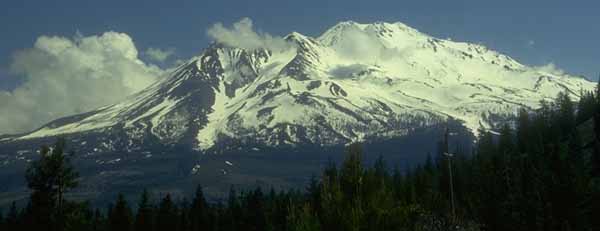
| Mount Shasta, part of the Cascade Range, looms large above the Shasta Basin landscape. |
|
Mount Shasta dominates the landscape almost everywhere in the Shasta River watershed. At 14,162 feet high, the mountain looms far above everything else. Several glaciers exist on the mountain, and glaciers descended the slopes of the mountain to an altitude of 2,800 feet during the Pleistocene epoch . Glacial moraines deposited during that time can be seen in the southern part of the valley. Today the glaciers continue to deposit materials on the lower northwest flank of Mt. Shasta. A geologist recently discovered that the hillocks covering much of the central valley floor were deposited in a huge debris-avalanche (Crandell, 1989). Unknown factors, possibly the rapid melting of glaciers or of a frozen crater lake, supersaturated the conglomerate of sand, gravel, old lava and ash that formed the mountain, causing it to liquefy and flow outwards to the north, completely filling the area we now know as the Shasta Valley, and flowing into the Klamath River. Large chunks of consolidated material from this debris flow remain today as rounded hills interspersed with depressions. The depressions fill with water in the winter, and provide wetland habitat. These formations can be seen along Interstate 5 between Weed and Grenada. |
|
|
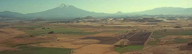
| Black Butte, the small, cone-shaped mountain to the right of Mt. Shasta, is approximately where a huge mountain that liquefied once stood. The hillocks on the Shasta Valley floor were formed from the material that once made up the mountain. Mt. Eddy, part of the Klamath Mountains, is on the right. |
![]()
References
Clawson, R.F., D.J. Cahoon, and J.M. Lacey. 1986. Shasta/Klamath Rivers Water Quality Study. California Department of Water Resources, Northern District. Sacramento, CA. 28 pp. [75kb]**
Crandell, D.R. 1989. Gigantic debris avalanche of Pleistocene age from ancestral Mount Shasta Volcano, California, and debris-avalanche hazard zonation. U.S. Geological Survey Bulletin 1861. 32 pp. [3.2Mb]
| www.krisweb.com |