|
Area/Topic | Bibliography | Background | Hypotheses | Home |
Photo Pages: Meta Information
This page contains detailed information from the KRIS Photodatabase table about photos from sub-basin Corte Madera Creek and series GIS: Geologic and Sediment Maps for Corte Madera Cr 1999. For a list of photo pages sorted by series, click here. For a list of photo pages sorted by sub-basin, click here.
| Agency | Stetson Engineers, Inc |
| Basin | East Marin-Sonoma |
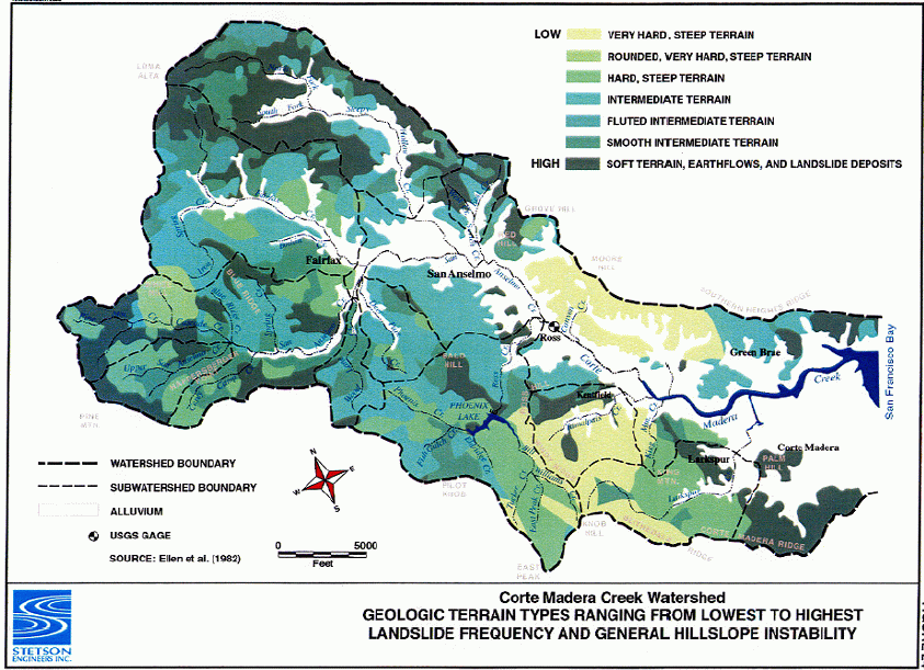
| Caption | This image reflects hillslope instability by geologic terrain type within the Corte Madera watershed. The figure is from Stetson Engineers, Inc. (2000). |
| CaptionTemplate | [Description] |
| Category | GIS |
| Description | This image reflects hillslope instability by geologic terrain type within the Corte Madera watershed. The figure is from Stetson Engineers, Inc. (2000). |
| Filename | stetson_geoinsatbility.gif |
| Filesize | 179721 |
| Meta_Id | FCMCW_sed |
| Notefile | emarins.htm#stetson |
| Path | topics/cm/stetson_geoinsatbility.gif |
| Photo Number | 3 |
| Restriction | None |
| Series | GIS: Geologic and Sediment Maps for Corte Madera Cr 1999 |
| SubBasin | Corte Madera Creek |
| UpdateDate | 8/26/2006 |
| UpdateName | JEA |
| Agency | Stetson Engineers, Inc |
| Basin | East Marin-Sonoma |
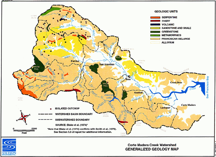
| Caption | This image shows the dominate geological formations in the Corte Madera watershed. The figure is from Stetson Engineers, Inc. (2000). |
| CaptionTemplate | [Description] |
| Category | GIS |
| Description | This image shows the dominate geological formations in the Corte Madera watershed. The figure is from Stetson Engineers, Inc. (2000). |
| Filename | stetson_geomap.gif |
| Filesize | 143746 |
| Meta_Id | FCMCW_sed |
| Notefile | emarins.htm#stetson |
| Path | topics/cm/stetson_geomap.gif |
| Photo Number | 1 |
| Restriction | None |
| Series | GIS: Geologic and Sediment Maps for Corte Madera Cr 1999 |
| SubBasin | Corte Madera Creek |
| UpdateDate | 8/26/2006 |
| UpdateName | JEA |
| Agency | Stetson Engineers, Inc |
| Basin | East Marin-Sonoma |
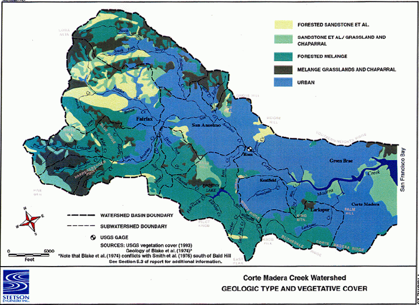
| Caption | This image relates vegetation cover and geological formation type within the Corte Madera watershed. The figure is from Stetson Engineers, Inc. (2000). |
| CaptionTemplate | [Description] |
| Category | GIS |
| Description | This image relates vegetation cover and geological formation type within the Corte Madera watershed. The figure is from Stetson Engineers, Inc. (2000). |
| Filename | stetson_geotype_veg.gif |
| Filesize | 191568 |
| Meta_Id | FCMCW_sed |
| Notefile | emarins.htm#stetson |
| Path | topics/cm/stetson_geotype_veg.gif |
| Photo Number | 2 |
| Restriction | None |
| Series | GIS: Geologic and Sediment Maps for Corte Madera Cr 1999 |
| SubBasin | Corte Madera Creek |
| UpdateDate | 8/26/2006 |
| UpdateName | JEA |
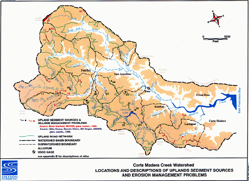
| Agency | Stetson Engineers, Inc |
| Basin | East Marin-Sonoma |
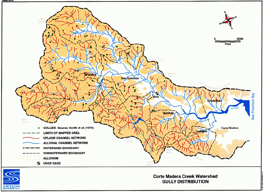
| Caption | This image shows the locations of gully erosion sources within the Corte Madera Creek watershed. The figure is from Stetson Engineers, Inc. (2000). |
| CaptionTemplate | [Description] |
| Category | GIS |
| Description | This image shows the locations of gully erosion sources within the Corte Madera Creek watershed. The figure is from Stetson Engineers, Inc. (2000). |
| Filename | stetson_gully_distribution.gif |
| Filesize | 152155 |
| Meta_Id | FCMCW_sed |
| Notefile | emarins.htm#stetson |
| Path | topics/cm/stetson_gully_distribution.gif |
| Photo Number | 5 |
| Restriction | None |
| Series | GIS: Geologic and Sediment Maps for Corte Madera Cr 1999 |
| SubBasin | Corte Madera Creek |
| UpdateDate | 8/26/2006 |
| UpdateName | JEA |
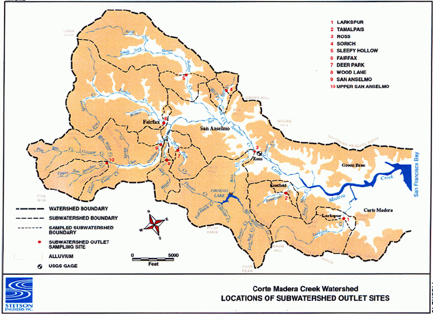
| Agency | Stetson Engineers, Inc |
| Basin | East Marin-Sonoma |
| Caption | This image show sample sites used during the Stetson Engineers, Inc (2000) "Geomorphic Assessment of the Corte Madera Creek Watershed". |
| CaptionTemplate | [Description] |
| Category | GIS |
| Description | This image show sample sites used during the Stetson Engineers, Inc (2000) "Geomorphic Assessment of the Corte Madera Creek Watershed". |
| Filename | stetson_samplesites.gif |
| Filesize | 148071 |
| Meta_Id | FCMCW_sed |
| Notefile | emarins.htm#stetson |
| Path | topics/cm/stetson_samplesites.gif |
| Photo Number | 1 |
| Restriction | None |
| Series | GIS: Geologic and Sediment Maps for Corte Madera Cr 1999 |
| SubBasin | Corte Madera Creek |
| UpdateDate | 8/26/2006 |
| UpdateName | JEA |
| Agency | Stetson Engineers, Inc |
| Basin | East Marin-Sonoma |
| Caption | This image shows the locations of active sediment sources within the Corte Madera Creek watershed. The figure is from Stetson Engineers, Inc. (2000). |
| CaptionTemplate | [Description] |
| Category | GIS |
| Description | This image shows the locations of active sediment sources within the Corte Madera Creek watershed. The figure is from Stetson Engineers, Inc. (2000). |
| Filename | stetson_sediment_sources.gif |
| Filesize | 148449 |
| Meta_Id | FCMCW_sed |
| Notefile | emarins.htm#stetson |
| Path | topics/cm/stetson_sediment_sources.gif |
| Photo Number | 6 |
| Restriction | None |
| Series | GIS: Geologic and Sediment Maps for Corte Madera Cr 1999 |
| SubBasin | Corte Madera Creek |
| UpdateDate | 8/26/2006 |
| UpdateName | JEA |
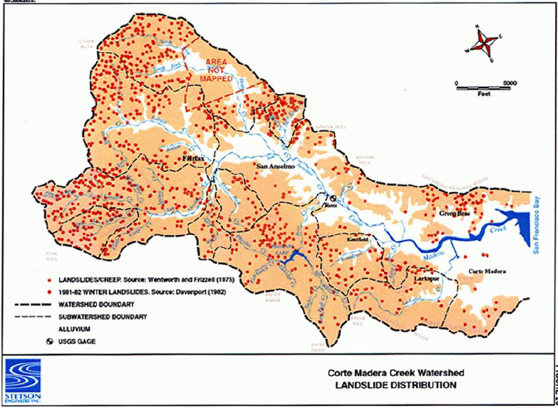
| Agency | Stetson Engineers, Inc |
| Basin | East Marin-Sonoma |
| Caption | This image shows the locations of landslides within the Corte Madera Creek watershed. The figure is from Stetson Engineers, Inc. (2000). |
| CaptionTemplate | [Description] |
| Category | GIS |
| Description | This image shows the locations of landslides within the Corte Madera Creek watershed. The figure is from Stetson Engineers, Inc. (2000). |
| Filename | ststson_landslide_distribution.gif |
| Filesize | 149455 |
| Meta_Id | FCMCW_sed |
| Notefile | emarins.htm#stetson |
| Path | topics/cm/ststson_landslide_distribution.gif |
| Photo Number | 4 |
| Restriction | None |
| Series | GIS: Geologic and Sediment Maps for Corte Madera Cr 1999 |
| SubBasin | Corte Madera Creek |
| UpdateDate | 8/26/2006 |
| UpdateName | JEA |
| www.krisweb.com |