| Agency |
Southern Sonoma County Resource Conservation District |
| Basin |
East Marin-Sonoma |
| Caption |
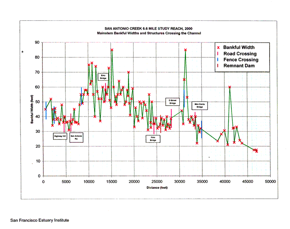
This graph shows mainstem bankfull widths and structures crossing the channel going upstream in a study section of San Antonio Creek, a tributary of the Petaluma River, evaluated during September through November 2000. Data were collected by San Francisco Estuary Institute staff for the Southern Sonoma County Resource Conservation District. This image was taken from Collins, 2000. |
| CaptionTemplate |
[Description] |
| Category |
Data Charts |
| Description |
This graph shows mainstem bankfull widths and structures crossing the channel going upstream in a study section of San Antonio Creek, a tributary of the Petaluma River, evaluated during September through November 2000. Data were collected by San Francisco Estuary Institute staff for the Southern Sonoma County Resource Conservation District. This image was taken from Collins, 2000. |
| Filename |
collins_sanant_bankfulwidths.gif |
| Filesize |
71482 |
| Meta_Id |
Collins_sanant |
| Notefile |
emarins.htm#collins |
| Path |
topics/pr/collins_sanant_bankfulwidths.gif |
| Photo Number |
1 |
| Restriction |
None |
| Series |
Monitoring: Charts from Habitat and Sediment Surveys in San Antonio Creek 2000 |
| SubBasin |
Petaluma River |
| UpdateDate |
8/26/2006 |
| UpdateName |
JEA |
| Agency |
Southern Sonoma County Resource Conservation District |
| Basin |
East Marin-Sonoma |
| Caption |
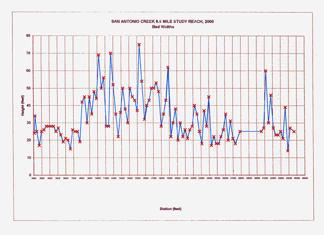
This graph shows bed widths going upstream in a study section of San Antonio Creek, a tributary of the Petaluma River, evaluated during September through November 2000. Data were collected by San Francisco Estuary Institute staff for the Southern Sonoma County Resource Conservation District. This image was taken from Collins, 2000. |
| CaptionTemplate |
[Description] |
| Category |
Data Charts |
| Description |
This graph shows bed widths going upstream in a study section of San Antonio Creek, a tributary of the Petaluma River, evaluated during September through November 2000. Data were collected by San Francisco Estuary Institute staff for the Southern Sonoma County Resource Conservation District. This image was taken from Collins, 2000. |
| Filename |
collins_sanant_bedwidths.gif |
| Filesize |
55929 |
| Meta_Id |
Collins_sanant |
| Notefile |
emarins.htm#collins |
| Path |
topics/pr/collins_sanant_bedwidths.gif |
| Photo Number |
2 |
| Restriction |
None |
| Series |
Monitoring: Charts from Habitat and Sediment Surveys in San Antonio Creek 2000 |
| SubBasin |
Petaluma River |
| UpdateDate |
8/26/2006 |
| UpdateName |
JEA |
| Agency |
Southern Sonoma County Resource Conservation District |
| Basin |
East Marin-Sonoma |
| Caption |
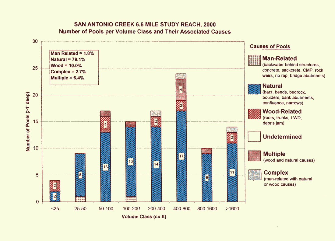
This graph shows the number of pools per volume class and their associated causes per reach in a study section of San Antonio Creek, a tributary of the Petaluma River, evaluated during September through November 2000. Data were collected by San Francisco Estuary Institute staff for the Southern Sonoma County Resource Conservation District. This image was taken from Collins, 2000. |
| CaptionTemplate |
[Description] |
| Category |
Monitoring |
| Description |
This graph shows the number of pools per volume class and their associated causes per reach in a study section of San Antonio Creek, a tributary of the Petaluma River, evaluated during September through November 2000. Data were collected by San Francisco Estuary Institute staff for the Southern Sonoma County Resource Conservation District. This image was taken from Collins, 2000. |
| Filename |
collins_sanant_poolcauses.gif |
| Filesize |
52906 |
| Meta_Id |
Collins_sanant |
| Notefile |
emarins.htm#collins |
| Path |
topics/pr/collins_sanant_poolcauses.gif |
| Photo Number |
2 |
| Restriction |
None |
| Series |
Monitoring: Charts from Habitat and Sediment Surveys in San Antonio Creek 2000 |
| SubBasin |
Petaluma River |
| UpdateDate |
8/26/2006 |
| UpdateName |
JEA |
| Agency |
Southern Sonoma County Resource Conservation District |
| Basin |
East Marin-Sonoma |
| Caption |
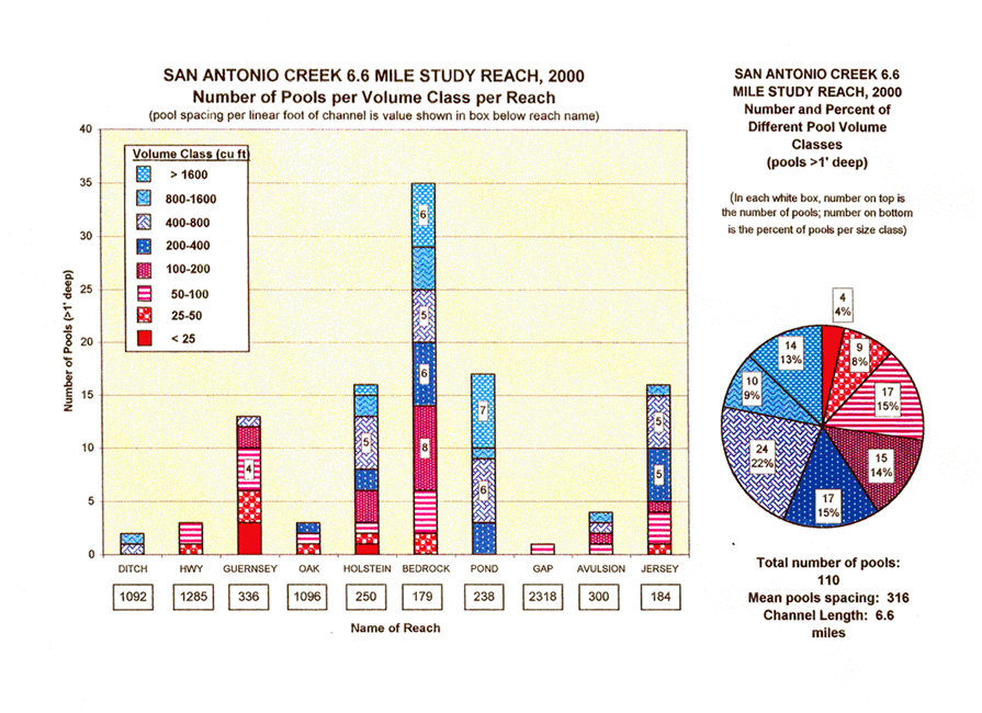
This graph shows the number of pools per volume class per reach in a study section of San Antonio Creek, a tributary of the Petaluma River, evaluated during September through November 2000. The reaches are arranged going upstream from left to right. Data were collected by San Francisco Estuary Institute staff for the Southern Sonoma County Resource Conservation District. This image was taken from Collins, 2000. |
| CaptionTemplate |
[Description] |
| Category |
Monitoring |
| Description |
This graph shows the number of pools per volume class per reach in a study section of San Antonio Creek, a tributary of the Petaluma River, evaluated during September through November 2000. The reaches are arranged going upstream from left to right. Data were collected by San Francisco Estuary Institute staff for the Southern Sonoma County Resource Conservation District. This image was taken from Collins, 2000. |
| Filename |
collins_sanant_poolsperreach.gif |
| Filesize |
151607 |
| Meta_Id |
Collins_sanant |
| Notefile |
emarins.htm#collins |
| Path |
topics/pr/collins_sanant_poolsperreach.gif |
| Photo Number |
1 |
| Restriction |
None |
| Series |
Monitoring: Charts from Habitat and Sediment Surveys in San Antonio Creek 2000 |
| SubBasin |
Petaluma River |
| UpdateDate |
8/26/2006 |
| UpdateName |
JEA |
| Agency |
Southern Sonoma County Resource Conservation District |
| Basin |
East Marin-Sonoma |
| Caption |
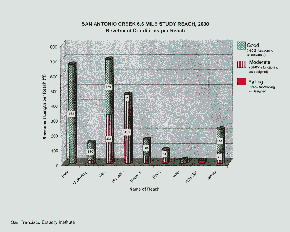
This graph shows the revetment conditions per reach in a study section of San Antonio Creek, a tributary of the Petaluma River, evaluated during September through November 2000. The reaches are arranged going upstream from left to right. Data were collected by San Francisco Estuary Institute staff for the Southern Sonoma County Resource Conservation District. This image was taken from Collins, 2000. |
| CaptionTemplate |
[Description] |
| Category |
Monitoring |
| Description |
This graph shows the revetment conditions per reach in a study section of San Antonio Creek, a tributary of the Petaluma River, evaluated during September through November 2000. The reaches are arranged going upstream from left to right. Data were collected by San Francisco Estuary Institute staff for the Southern Sonoma County Resource Conservation District. This image was taken from Collins, 2000. |
| Filename |
collins_sanant_revetcond.gif |
| Filesize |
83592 |
| Meta_Id |
Collins_sanant |
| Notefile |
emarins.htm#collins |
| Path |
topics/pr/collins_sanant_revetcond.gif |
| Photo Number |
2 |
| Restriction |
None |
| Series |
Monitoring: Charts from Habitat and Sediment Surveys in San Antonio Creek 2000 |
| SubBasin |
Petaluma River |
| UpdateDate |
8/26/2006 |
| UpdateName |
JEA |
| Agency |
Southern Sonoma County Resource Conservation District |
| Basin |
East Marin-Sonoma |
| Caption |
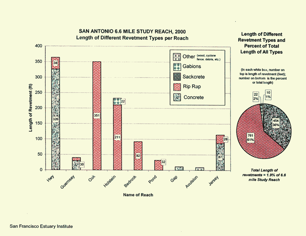
This graph shows the length of different revetment types per reach in a study section of San Antonio Creek, a tributary of the Petaluma River, evaluated during September through November 2000. The reaches are arranged going upstream from left to right. Data were collected by San Francisco Estuary Institute staff for the Southern Sonoma County Resource Conservation District. This image was taken from Collins, 2000. |
| CaptionTemplate |
[Description] |
| Category |
Monitoring |
| Description |
This graph shows the length of different revetment types per reach in a study section of San Antonio Creek, a tributary of the Petaluma River, evaluated during September through November 2000. The reaches are arranged going upstream from left to right. Data were collected by San Francisco Estuary Institute staff for the Southern Sonoma County Resource Conservation District. This image was taken from Collins, 2000. |
| Filename |
collins_sanant_revetlengths.gif |
| Filesize |
53743 |
| Meta_Id |
Collins_sanant |
| Notefile |
emarins.htm#collins |
| Path |
topics/pr/collins_sanant_revetlengths.gif |
| Photo Number |
1 |
| Restriction |
None |
| Series |
Monitoring: Charts from Habitat and Sediment Surveys in San Antonio Creek 2000 |
| SubBasin |
Petaluma River |
| UpdateDate |
8/26/2006 |
| UpdateName |
JEA |