| Hyperlink |
Agency |
Basin |
Bearing Direction |
Caption |
CaptionTemplate |
Category |
Datum_Zone |
Description |
ExtraField1 |
ExtraField2 |
Filename |
Filesize |
Funder |
GIS_Project |
Graphic |
Hotlinkfield |
KRIS_Hotlink |
Latitud_DD |
Longit_DD |
Meta_Id |
Miscellaneous_Notes |
Notefile |
Path |
Photo Number |
Photodate |
Photographer |
ProjectLocation |
ProjectName |
Restriction |
Series |
Shapefile |
Site_Name |
Site_Type |
Streamname |
SubBasin |
Time |
UTM_E |
UTM_N |
UpdateDate |
UpdateName |
Watershed |
|
View
|
Marin County Flood Control and Water Conservation District |
East Marin-Sonoma |
-- |
This photo shows Arroyo Avichi at the Nave Center on Novato, in Novato, part of the Novato Creek watershed (flood control zone 1). The following flood control channel maintenance Best Management Practices (BMPs) are performed at this location: Sediment and Debris Removal; Vegetation Management; Bank Stabilization; Temporary Water Diversions. Photo is part of a collection provided by the Marin County Flood Control and Water Conservation District, showing reaches of creeks in Marin County where channel maintenance activities are performed using BMPs that pose minimal threat to water quality and beneficial uses. For more information on BMPs and a Proposed Regional General Permit, see http://www.mcstoppp.org/FloodControlBMPs.htm |
This photo shows [ProjectLocation], in [ExtraField2], part of the [Watershed] watershed ([ExtraField1]). [Description]. Photo is part of a collection provided by the Marin County Flood Control and Water Conservation District, showing reaches of creeks in Marin County where channel maintenance activities are performed using BMPs that pose minimal threat to water quality and beneficial uses. For more information on BMPs and a Proposed Regional General Permit, see http://www.mcstoppp.org/FloodControlBMPs.htm |
Flood Control Maintenance |
-- |
The following flood control channel maintenance Best Management Practices (BMPs) are performed at this location: Sediment and Debris Removal; Vegetation Management; Bank Stabilization; Temporary Water Diversions |
flood control zone 1 |
Novato |
Arroyo Avichi (Nave Center on Novato).2.JPG |
375459 |
-- |
-- |
-- |
-- |
-- |
-- |
-- |
-- |
-- |
-- |
mcfcwcd/chan_maint/zone_1/Arroyo Avichi (Nave Center on Novato).2.JPG |
-- |
-- |
-- |
Arroyo Avichi at the Nave Center on Novato |
-- |
-- |
Flood Control Maintenance: Marin County, Zone 1 - Novato Creek Watershed |
-- |
-- |
-- |
Arroyo Avichi |
Novato and Miller Creeks |
-- |
-- |
-- |
12/16/2006 |
JEA |
Novato Creek |
|
View
|
Marin County Flood Control and Water Conservation District |
East Marin-Sonoma |
-- |
This photo shows Arroyo Avichi at the Nave Center on Novato, in Novato, part of the Novato Creek watershed (flood control zone 1). The following flood control channel maintenance Best Management Practices (BMPs) are performed at this location: Sediment and Debris Removal; Vegetation Management; Bank Stabilization; Temporary Water Diversions. Photo is part of a collection provided by the Marin County Flood Control and Water Conservation District, showing reaches of creeks in Marin County where channel maintenance activities are performed using BMPs that pose minimal threat to water quality and beneficial uses. For more information on BMPs and a Proposed Regional General Permit, see http://www.mcstoppp.org/FloodControlBMPs.htm |
This photo shows [ProjectLocation], in [ExtraField2], part of the [Watershed] watershed ([ExtraField1]). [Description]. Photo is part of a collection provided by the Marin County Flood Control and Water Conservation District, showing reaches of creeks in Marin County where channel maintenance activities are performed using BMPs that pose minimal threat to water quality and beneficial uses. For more information on BMPs and a Proposed Regional General Permit, see http://www.mcstoppp.org/FloodControlBMPs.htm |
Flood Control Maintenance |
-- |
The following flood control channel maintenance Best Management Practices (BMPs) are performed at this location: Sediment and Debris Removal; Vegetation Management; Bank Stabilization; Temporary Water Diversions |
flood control zone 1 |
Novato |
Arroyo Avichi (Nave Center on Novato).JPG |
385024 |
-- |
-- |
-- |
-- |
-- |
-- |
-- |
-- |
-- |
-- |
mcfcwcd/chan_maint/zone_1/Arroyo Avichi (Nave Center on Novato).JPG |
-- |
-- |
-- |
Arroyo Avichi at the Nave Center on Novato |
-- |
-- |
Flood Control Maintenance: Marin County, Zone 1 - Novato Creek Watershed |
-- |
-- |
-- |
Arroyo Avichi |
Novato and Miller Creeks |
-- |
-- |
-- |
12/16/2006 |
JEA |
Novato Creek |
|
View
|
Marin County Flood Control and Water Conservation District |
East Marin-Sonoma |
-- |
This photo shows Arroyo Avichi at the end of Taft Ct, in Novato, part of the Novato Creek watershed (flood control zone 1). The following flood control channel maintenance Best Management Practices (BMPs) are performed at this location: Sediment and Debris Removal; Vegetation Management; Bank Stabilization; Temporary Water Diversions. Photo is part of a collection provided by the Marin County Flood Control and Water Conservation District, showing reaches of creeks in Marin County where channel maintenance activities are performed using BMPs that pose minimal threat to water quality and beneficial uses. For more information on BMPs and a Proposed Regional General Permit, see http://www.mcstoppp.org/FloodControlBMPs.htm |
This photo shows [ProjectLocation], in [ExtraField2], part of the [Watershed] watershed ([ExtraField1]). [Description]. Photo is part of a collection provided by the Marin County Flood Control and Water Conservation District, showing reaches of creeks in Marin County where channel maintenance activities are performed using BMPs that pose minimal threat to water quality and beneficial uses. For more information on BMPs and a Proposed Regional General Permit, see http://www.mcstoppp.org/FloodControlBMPs.htm |
Flood Control Maintenance |
-- |
The following flood control channel maintenance Best Management Practices (BMPs) are performed at this location: Sediment and Debris Removal; Vegetation Management; Bank Stabilization; Temporary Water Diversions |
flood control zone 1 |
Novato |
Arroyo Avichi (end of Taft Ct).3.JPG |
427646 |
-- |
-- |
-- |
-- |
-- |
-- |
-- |
-- |
-- |
-- |
mcfcwcd/chan_maint/zone_1/Arroyo Avichi (end of Taft Ct).3.JPG |
-- |
-- |
-- |
Arroyo Avichi at the end of Taft Ct |
-- |
-- |
Flood Control Maintenance: Marin County, Zone 1 - Novato Creek Watershed |
-- |
-- |
-- |
Arroyo Avichi |
Novato and Miller Creeks |
-- |
-- |
-- |
12/16/2006 |
JEA |
Novato Creek |
|
View
|
Marin County Flood Control and Water Conservation District |
East Marin-Sonoma |
-- |
This photo shows Arroyo Avichi at the end of Taft Ct, in Novato, part of the Novato Creek watershed (flood control zone 1). The following flood control channel maintenance Best Management Practices (BMPs) are performed at this location: Sediment and Debris Removal; Vegetation Management; Bank Stabilization; Temporary Water Diversions. Photo is part of a collection provided by the Marin County Flood Control and Water Conservation District, showing reaches of creeks in Marin County where channel maintenance activities are performed using BMPs that pose minimal threat to water quality and beneficial uses. For more information on BMPs and a Proposed Regional General Permit, see http://www.mcstoppp.org/FloodControlBMPs.htm |
This photo shows [ProjectLocation], in [ExtraField2], part of the [Watershed] watershed ([ExtraField1]). [Description]. Photo is part of a collection provided by the Marin County Flood Control and Water Conservation District, showing reaches of creeks in Marin County where channel maintenance activities are performed using BMPs that pose minimal threat to water quality and beneficial uses. For more information on BMPs and a Proposed Regional General Permit, see http://www.mcstoppp.org/FloodControlBMPs.htm |
Flood Control Maintenance |
-- |
The following flood control channel maintenance Best Management Practices (BMPs) are performed at this location: Sediment and Debris Removal; Vegetation Management; Bank Stabilization; Temporary Water Diversions |
flood control zone 1 |
Novato |
Arroyo Avichi (end of Taft Ct.).2.JPG |
433275 |
-- |
-- |
-- |
-- |
-- |
-- |
-- |
-- |
-- |
-- |
mcfcwcd/chan_maint/zone_1/Arroyo Avichi (end of Taft Ct.).2.JPG |
-- |
-- |
-- |
Arroyo Avichi at the end of Taft Ct |
-- |
-- |
Flood Control Maintenance: Marin County, Zone 1 - Novato Creek Watershed |
-- |
-- |
-- |
Arroyo Avichi |
Novato and Miller Creeks |
-- |
-- |
-- |
12/16/2006 |
JEA |
Novato Creek |
|
View
|
Marin County Flood Control and Water Conservation District |
East Marin-Sonoma |
-- |
This photo shows Arroyo Avichi at the end of Taft Ct, in Novato, part of the Novato Creek watershed (flood control zone 1). The following flood control channel maintenance Best Management Practices (BMPs) are performed at this location: Sediment and Debris Removal; Vegetation Management; Bank Stabilization; Temporary Water Diversions. Photo is part of a collection provided by the Marin County Flood Control and Water Conservation District, showing reaches of creeks in Marin County where channel maintenance activities are performed using BMPs that pose minimal threat to water quality and beneficial uses. For more information on BMPs and a Proposed Regional General Permit, see http://www.mcstoppp.org/FloodControlBMPs.htm |
This photo shows [ProjectLocation], in [ExtraField2], part of the [Watershed] watershed ([ExtraField1]). [Description]. Photo is part of a collection provided by the Marin County Flood Control and Water Conservation District, showing reaches of creeks in Marin County where channel maintenance activities are performed using BMPs that pose minimal threat to water quality and beneficial uses. For more information on BMPs and a Proposed Regional General Permit, see http://www.mcstoppp.org/FloodControlBMPs.htm |
Flood Control Maintenance |
-- |
The following flood control channel maintenance Best Management Practices (BMPs) are performed at this location: Sediment and Debris Removal; Vegetation Management; Bank Stabilization; Temporary Water Diversions |
flood control zone 1 |
Novato |
Arroyo Avichi (end of Taft Ct.).JPG |
442853 |
-- |
-- |
-- |
-- |
-- |
-- |
-- |
-- |
-- |
-- |
mcfcwcd/chan_maint/zone_1/Arroyo Avichi (end of Taft Ct.).JPG |
-- |
-- |
-- |
Arroyo Avichi at the end of Taft Ct |
-- |
-- |
Flood Control Maintenance: Marin County, Zone 1 - Novato Creek Watershed |
-- |
-- |
-- |
Arroyo Avichi |
Novato and Miller Creeks |
-- |
-- |
-- |
12/16/2006 |
JEA |
Novato Creek |
|
View
|
Marin County Flood Control and Water Conservation District |
East Marin-Sonoma |
-- |
This photo shows Arroyo San Jose at the Shell Station off Enfrente, in Novato, part of the Novato Creek watershed (flood control zone 1). The following flood control channel maintenance Best Management Practices (BMPs) are performed at this location: Vegetation Management; Bank Stabilization; Temporary Water Diversions. Photo is part of a collection provided by the Marin County Flood Control and Water Conservation District, showing reaches of creeks in Marin County where channel maintenance activities are performed using BMPs that pose minimal threat to water quality and beneficial uses. For more information on BMPs and a Proposed Regional General Permit, see http://www.mcstoppp.org/FloodControlBMPs.htm |
This photo shows [ProjectLocation], in [ExtraField2], part of the [Watershed] watershed ([ExtraField1]). [Description]. Photo is part of a collection provided by the Marin County Flood Control and Water Conservation District, showing reaches of creeks in Marin County where channel maintenance activities are performed using BMPs that pose minimal threat to water quality and beneficial uses. For more information on BMPs and a Proposed Regional General Permit, see http://www.mcstoppp.org/FloodControlBMPs.htm |
Flood Control Maintenance |
-- |
The following flood control channel maintenance Best Management Practices (BMPs) are performed at this location: Vegetation Management; Bank Stabilization; Temporary Water Diversions |
flood control zone 1 |
Novato |
Arroyo San Jose (Shell Sta off Enfrente).JPG |
480259 |
-- |
-- |
-- |
-- |
-- |
-- |
-- |
-- |
-- |
-- |
mcfcwcd/chan_maint/zone_1/Arroyo San Jose (Shell Sta off Enfrente).JPG |
-- |
-- |
-- |
Arroyo San Jose at the Shell Station off Enfrente |
-- |
-- |
Flood Control Maintenance: Marin County, Zone 1 - Novato Creek Watershed |
-- |
-- |
-- |
Arroyo San Jose |
Novato and Miller Creeks |
-- |
-- |
-- |
12/16/2006 |
JEA |
Novato Creek |
|
View
|
Marin County Flood Control and Water Conservation District |
East Marin-Sonoma |
-- |
This photo shows Arroyo San Jose at the end of chain fence on Ignacio downstream view, in Novato, part of the Novato Creek watershed (flood control zone 1). The following flood control channel maintenance Best Management Practices (BMPs) are performed at this location: Vegetation Management; Bank Stabilization; Temporary Water Diversions. Photo is part of a collection provided by the Marin County Flood Control and Water Conservation District, showing reaches of creeks in Marin County where channel maintenance activities are performed using BMPs that pose minimal threat to water quality and beneficial uses. For more information on BMPs and a Proposed Regional General Permit, see http://www.mcstoppp.org/FloodControlBMPs.htm |
This photo shows [ProjectLocation], in [ExtraField2], part of the [Watershed] watershed ([ExtraField1]). [Description]. Photo is part of a collection provided by the Marin County Flood Control and Water Conservation District, showing reaches of creeks in Marin County where channel maintenance activities are performed using BMPs that pose minimal threat to water quality and beneficial uses. For more information on BMPs and a Proposed Regional General Permit, see http://www.mcstoppp.org/FloodControlBMPs.htm |
Flood Control Maintenance |
-- |
The following flood control channel maintenance Best Management Practices (BMPs) are performed at this location: Vegetation Management; Bank Stabilization; Temporary Water Diversions |
flood control zone 1 |
Novato |
Arroyo San Jose (end of chain fence on Ignacio).2.JPG |
502165 |
-- |
-- |
-- |
-- |
-- |
-- |
-- |
-- |
-- |
-- |
mcfcwcd/chan_maint/zone_1/Arroyo San Jose (end of chain fence on Ignacio).2.JPG |
-- |
-- |
-- |
Arroyo San Jose at the end of chain fence on Ignacio downstream view |
-- |
-- |
Flood Control Maintenance: Marin County, Zone 1 - Novato Creek Watershed |
-- |
-- |
-- |
Arroyo San Jose |
Novato and Miller Creeks |
-- |
-- |
-- |
12/16/2006 |
JEA |
Novato Creek |
|
View
|
Marin County Flood Control and Water Conservation District |
East Marin-Sonoma |
-- |
This photo shows Arroyo San Jose at the end of chain fence on Ignacio, in Novato, part of the Novato Creek watershed (flood control zone 1). The following flood control channel maintenance Best Management Practices (BMPs) are performed at this location: Vegetation Management; Bank Stabilization; Temporary Water Diversions. Photo is part of a collection provided by the Marin County Flood Control and Water Conservation District, showing reaches of creeks in Marin County where channel maintenance activities are performed using BMPs that pose minimal threat to water quality and beneficial uses. For more information on BMPs and a Proposed Regional General Permit, see http://www.mcstoppp.org/FloodControlBMPs.htm |
This photo shows [ProjectLocation], in [ExtraField2], part of the [Watershed] watershed ([ExtraField1]). [Description]. Photo is part of a collection provided by the Marin County Flood Control and Water Conservation District, showing reaches of creeks in Marin County where channel maintenance activities are performed using BMPs that pose minimal threat to water quality and beneficial uses. For more information on BMPs and a Proposed Regional General Permit, see http://www.mcstoppp.org/FloodControlBMPs.htm |
Flood Control Maintenance |
-- |
The following flood control channel maintenance Best Management Practices (BMPs) are performed at this location: Vegetation Management; Bank Stabilization; Temporary Water Diversions |
flood control zone 1 |
Novato |
Arroyo San Jose (end of chain fence on Ignacio).JPG |
467160 |
-- |
-- |
-- |
-- |
-- |
-- |
-- |
-- |
-- |
-- |
mcfcwcd/chan_maint/zone_1/Arroyo San Jose (end of chain fence on Ignacio).JPG |
-- |
-- |
-- |
Arroyo San Jose at the end of chain fence on Ignacio |
-- |
-- |
Flood Control Maintenance: Marin County, Zone 1 - Novato Creek Watershed |
-- |
-- |
-- |
Arroyo San Jose |
Novato and Miller Creeks |
-- |
-- |
-- |
12/16/2006 |
JEA |
Novato Creek |
|
View
|
Marin County Flood Control and Water Conservation District |
East Marin-Sonoma |
-- |
This photo shows Cheda Cr at Cowbarn Ln, in Novato, part of the Novato Creek watershed (flood control zone 1). The following flood control channel maintenance Best Management Practices (BMPs) are performed at this location: Vegetation Management; Maintenance, Repair, Rehabilitation, Replacement of Structures; Bank Stabilization; Temporary Water Diversions. Photo is part of a collection provided by the Marin County Flood Control and Water Conservation District, showing reaches of creeks in Marin County where channel maintenance activities are performed using BMPs that pose minimal threat to water quality and beneficial uses. For more information on BMPs and a Proposed Regional General Permit, see http://www.mcstoppp.org/FloodControlBMPs.htm |
This photo shows [ProjectLocation], in [ExtraField2], part of the [Watershed] watershed ([ExtraField1]). [Description]. Photo is part of a collection provided by the Marin County Flood Control and Water Conservation District, showing reaches of creeks in Marin County where channel maintenance activities are performed using BMPs that pose minimal threat to water quality and beneficial uses. For more information on BMPs and a Proposed Regional General Permit, see http://www.mcstoppp.org/FloodControlBMPs.htm |
Flood Control Maintenance |
-- |
The following flood control channel maintenance Best Management Practices (BMPs) are performed at this location: Vegetation Management; Maintenance, Repair, Rehabilitation, Replacement of Structures; Bank Stabilization; Temporary Water Diversions |
flood control zone 1 |
Novato |
Cheda Cr (Cowbarn Ln).JPG |
347425 |
-- |
-- |
-- |
-- |
-- |
-- |
-- |
-- |
-- |
-- |
mcfcwcd/chan_maint/zone_1/Cheda Cr (Cowbarn Ln).JPG |
-- |
-- |
-- |
Cheda Cr at Cowbarn Ln |
-- |
-- |
Flood Control Maintenance: Marin County, Zone 1 - Novato Creek Watershed |
-- |
-- |
-- |
Cheda Cr |
Novato and Miller Creeks |
-- |
-- |
-- |
12/16/2006 |
JEA |
Novato Creek |
|
View
|
Marin County Flood Control and Water Conservation District |
East Marin-Sonoma |
-- |
This photo shows Ignacio Cr at Ignacio & Indian Way, in Novato, part of the Novato Creek watershed (flood control zone 1). The following flood control channel maintenance Best Management Practices (BMPs) are performed at this location: Sediment and Debris Removal; Vegetation Management; Bank Stabilization; Temporary Water Diversions. Photo is part of a collection provided by the Marin County Flood Control and Water Conservation District, showing reaches of creeks in Marin County where channel maintenance activities are performed using BMPs that pose minimal threat to water quality and beneficial uses. For more information on BMPs and a Proposed Regional General Permit, see http://www.mcstoppp.org/FloodControlBMPs.htm |
This photo shows [ProjectLocation], in [ExtraField2], part of the [Watershed] watershed ([ExtraField1]). [Description]. Photo is part of a collection provided by the Marin County Flood Control and Water Conservation District, showing reaches of creeks in Marin County where channel maintenance activities are performed using BMPs that pose minimal threat to water quality and beneficial uses. For more information on BMPs and a Proposed Regional General Permit, see http://www.mcstoppp.org/FloodControlBMPs.htm |
Flood Control Maintenance |
-- |
The following flood control channel maintenance Best Management Practices (BMPs) are performed at this location: Sediment and Debris Removal; Vegetation Management; Bank Stabilization; Temporary Water Diversions |
flood control zone 1 |
Novato |
Ignacio Cr (Ignacio &Indian Way).JPG |
454423 |
-- |
-- |
-- |
-- |
-- |
-- |
-- |
-- |
-- |
-- |
mcfcwcd/chan_maint/zone_1/Ignacio Cr (Ignacio &Indian Way).JPG |
-- |
-- |
-- |
Ignacio Cr at Ignacio & Indian Way |
-- |
-- |
Flood Control Maintenance: Marin County, Zone 1 - Novato Creek Watershed |
-- |
-- |
-- |
Ignacio Cr |
Novato and Miller Creeks |
-- |
-- |
-- |
12/16/2006 |
JEA |
Novato Creek |
|
View
|
Marin County Flood Control and Water Conservation District |
East Marin-Sonoma |
-- |
This photo shows Ignacio Cr at Ignacio across fr Montura Wy, in Novato, part of the Novato Creek watershed (flood control zone 1). The following flood control channel maintenance Best Management Practices (BMPs) are performed at this location: Vegetation Management; Bank Stabilization; Temporary Water Diversions. Photo is part of a collection provided by the Marin County Flood Control and Water Conservation District, showing reaches of creeks in Marin County where channel maintenance activities are performed using BMPs that pose minimal threat to water quality and beneficial uses. For more information on BMPs and a Proposed Regional General Permit, see http://www.mcstoppp.org/FloodControlBMPs.htm |
This photo shows [ProjectLocation], in [ExtraField2], part of the [Watershed] watershed ([ExtraField1]). [Description]. Photo is part of a collection provided by the Marin County Flood Control and Water Conservation District, showing reaches of creeks in Marin County where channel maintenance activities are performed using BMPs that pose minimal threat to water quality and beneficial uses. For more information on BMPs and a Proposed Regional General Permit, see http://www.mcstoppp.org/FloodControlBMPs.htm |
Flood Control Maintenance |
-- |
The following flood control channel maintenance Best Management Practices (BMPs) are performed at this location: Vegetation Management; Bank Stabilization; Temporary Water Diversions |
flood control zone 1 |
Novato |
Ignacio Cr (Ignacio across fr Montura Wy).JPG |
439525 |
-- |
-- |
-- |
-- |
-- |
-- |
-- |
-- |
-- |
-- |
mcfcwcd/chan_maint/zone_1/Ignacio Cr (Ignacio across fr Montura Wy).JPG |
-- |
-- |
-- |
Ignacio Cr at Ignacio across fr Montura Wy |
-- |
-- |
Flood Control Maintenance: Marin County, Zone 1 - Novato Creek Watershed |
-- |
-- |
-- |
Ignacio Cr |
Novato and Miller Creeks |
-- |
-- |
-- |
12/16/2006 |
JEA |
Novato Creek |
|
View
|
Marin County Flood Control and Water Conservation District |
East Marin-Sonoma |
-- |
This photo shows Lynwood Slough at Donna St, in Novato, part of the Novato Creek watershed (flood control zone 1). The following flood control channel maintenance Best Management Practices (BMPs) are performed at this location: Sediment and Debris Removal; Vegetation Management; Bank Stabilization; Temporary Water Diversions. Photo is part of a collection provided by the Marin County Flood Control and Water Conservation District, showing reaches of creeks in Marin County where channel maintenance activities are performed using BMPs that pose minimal threat to water quality and beneficial uses. For more information on BMPs and a Proposed Regional General Permit, see http://www.mcstoppp.org/FloodControlBMPs.htm |
This photo shows [ProjectLocation], in [ExtraField2], part of the [Watershed] watershed ([ExtraField1]). [Description]. Photo is part of a collection provided by the Marin County Flood Control and Water Conservation District, showing reaches of creeks in Marin County where channel maintenance activities are performed using BMPs that pose minimal threat to water quality and beneficial uses. For more information on BMPs and a Proposed Regional General Permit, see http://www.mcstoppp.org/FloodControlBMPs.htm |
Flood Control Maintenance |
-- |
The following flood control channel maintenance Best Management Practices (BMPs) are performed at this location: Sediment and Debris Removal; Vegetation Management; Bank Stabilization; Temporary Water Diversions |
flood control zone 1 |
Novato |
Lynwood Slough (Donna St).2.JPG |
394578 |
-- |
-- |
-- |
-- |
-- |
-- |
-- |
-- |
-- |
-- |
mcfcwcd/chan_maint/zone_1/Lynwood Slough (Donna St).2.JPG |
-- |
-- |
-- |
Lynwood Slough at Donna St |
-- |
-- |
Flood Control Maintenance: Marin County, Zone 1 - Novato Creek Watershed |
-- |
-- |
-- |
Lynwood Slough |
Novato and Miller Creeks |
-- |
-- |
-- |
12/16/2006 |
JEA |
Novato Creek |
|
View
|
Marin County Flood Control and Water Conservation District |
East Marin-Sonoma |
-- |
This photo shows Lynwood Slough at Donna St, in Novato, part of the Novato Creek watershed (flood control zone 1). The following flood control channel maintenance Best Management Practices (BMPs) are performed at this location: Sediment and Debris Removal; Vegetation Management; Bank Stabilization; Temporary Water Diversions. Photo is part of a collection provided by the Marin County Flood Control and Water Conservation District, showing reaches of creeks in Marin County where channel maintenance activities are performed using BMPs that pose minimal threat to water quality and beneficial uses. For more information on BMPs and a Proposed Regional General Permit, see http://www.mcstoppp.org/FloodControlBMPs.htm |
This photo shows [ProjectLocation], in [ExtraField2], part of the [Watershed] watershed ([ExtraField1]). [Description]. Photo is part of a collection provided by the Marin County Flood Control and Water Conservation District, showing reaches of creeks in Marin County where channel maintenance activities are performed using BMPs that pose minimal threat to water quality and beneficial uses. For more information on BMPs and a Proposed Regional General Permit, see http://www.mcstoppp.org/FloodControlBMPs.htm |
Flood Control Maintenance |
-- |
The following flood control channel maintenance Best Management Practices (BMPs) are performed at this location: Sediment and Debris Removal; Vegetation Management; Bank Stabilization; Temporary Water Diversions |
flood control zone 1 |
Novato |
Lynwood Slough (Donna St.).JPG |
196760 |
-- |
-- |
-- |
-- |
-- |
-- |
-- |
-- |
-- |
-- |
mcfcwcd/chan_maint/zone_1/Lynwood Slough (Donna St.).JPG |
-- |
-- |
-- |
Lynwood Slough at Donna St |
-- |
-- |
Flood Control Maintenance: Marin County, Zone 1 - Novato Creek Watershed |
-- |
-- |
-- |
Lynwood Slough |
Novato and Miller Creeks |
-- |
-- |
-- |
12/16/2006 |
JEA |
Novato Creek |
|
View
|
Marin County Flood Control and Water Conservation District |
East Marin-Sonoma |
-- |
This photo shows Lynwood Slough at Leafwood Dr, in Novato, part of the Novato Creek watershed (flood control zone 1). The following flood control channel maintenance Best Management Practices (BMPs) are performed at this location: Sediment and Debris Removal; Vegetation Management; Bank Stabilization; Temporary Water Diversions. Photo is part of a collection provided by the Marin County Flood Control and Water Conservation District, showing reaches of creeks in Marin County where channel maintenance activities are performed using BMPs that pose minimal threat to water quality and beneficial uses. For more information on BMPs and a Proposed Regional General Permit, see http://www.mcstoppp.org/FloodControlBMPs.htm |
This photo shows [ProjectLocation], in [ExtraField2], part of the [Watershed] watershed ([ExtraField1]). [Description]. Photo is part of a collection provided by the Marin County Flood Control and Water Conservation District, showing reaches of creeks in Marin County where channel maintenance activities are performed using BMPs that pose minimal threat to water quality and beneficial uses. For more information on BMPs and a Proposed Regional General Permit, see http://www.mcstoppp.org/FloodControlBMPs.htm |
Flood Control Maintenance |
-- |
The following flood control channel maintenance Best Management Practices (BMPs) are performed at this location: Sediment and Debris Removal; Vegetation Management; Bank Stabilization; Temporary Water Diversions |
flood control zone 1 |
Novato |
Lynwood Slough (Leafwood Dr).2.JPG |
241256 |
-- |
-- |
-- |
-- |
-- |
-- |
-- |
-- |
-- |
-- |
mcfcwcd/chan_maint/zone_1/Lynwood Slough (Leafwood Dr).2.JPG |
-- |
-- |
-- |
Lynwood Slough at Leafwood Dr |
-- |
-- |
Flood Control Maintenance: Marin County, Zone 1 - Novato Creek Watershed |
-- |
-- |
-- |
Lynwood Slough |
Novato and Miller Creeks |
-- |
-- |
-- |
12/16/2006 |
JEA |
Novato Creek |
|
View
|
Marin County Flood Control and Water Conservation District |
East Marin-Sonoma |
-- |
This photo shows Lynwood Slough at Leafwood Dr, in Novato, part of the Novato Creek watershed (flood control zone 1). The following flood control channel maintenance Best Management Practices (BMPs) are performed at this location: Sediment and Debris Removal; Vegetation Management; Bank Stabilization; Temporary Water Diversions. Photo is part of a collection provided by the Marin County Flood Control and Water Conservation District, showing reaches of creeks in Marin County where channel maintenance activities are performed using BMPs that pose minimal threat to water quality and beneficial uses. For more information on BMPs and a Proposed Regional General Permit, see http://www.mcstoppp.org/FloodControlBMPs.htm |
This photo shows [ProjectLocation], in [ExtraField2], part of the [Watershed] watershed ([ExtraField1]). [Description]. Photo is part of a collection provided by the Marin County Flood Control and Water Conservation District, showing reaches of creeks in Marin County where channel maintenance activities are performed using BMPs that pose minimal threat to water quality and beneficial uses. For more information on BMPs and a Proposed Regional General Permit, see http://www.mcstoppp.org/FloodControlBMPs.htm |
Flood Control Maintenance |
-- |
The following flood control channel maintenance Best Management Practices (BMPs) are performed at this location: Sediment and Debris Removal; Vegetation Management; Bank Stabilization; Temporary Water Diversions |
flood control zone 1 |
Novato |
Lynwood Slough (Leafwood Dr).3.JPG |
283811 |
-- |
-- |
-- |
-- |
-- |
-- |
-- |
-- |
-- |
-- |
mcfcwcd/chan_maint/zone_1/Lynwood Slough (Leafwood Dr).3.JPG |
-- |
-- |
-- |
Lynwood Slough at Leafwood Dr |
-- |
-- |
Flood Control Maintenance: Marin County, Zone 1 - Novato Creek Watershed |
-- |
-- |
-- |
Lynwood Slough |
Novato and Miller Creeks |
-- |
-- |
-- |
12/16/2006 |
JEA |
Novato Creek |
|
View
|
Marin County Flood Control and Water Conservation District |
East Marin-Sonoma |
-- |
This photo shows Lynwood Slough at Leafwood Dr, in Novato, part of the Novato Creek watershed (flood control zone 1). The following flood control channel maintenance Best Management Practices (BMPs) are performed at this location: Sediment and Debris Removal; Vegetation Management; Bank Stabilization; Temporary Water Diversions. Photo is part of a collection provided by the Marin County Flood Control and Water Conservation District, showing reaches of creeks in Marin County where channel maintenance activities are performed using BMPs that pose minimal threat to water quality and beneficial uses. For more information on BMPs and a Proposed Regional General Permit, see http://www.mcstoppp.org/FloodControlBMPs.htm |
This photo shows [ProjectLocation], in [ExtraField2], part of the [Watershed] watershed ([ExtraField1]). [Description]. Photo is part of a collection provided by the Marin County Flood Control and Water Conservation District, showing reaches of creeks in Marin County where channel maintenance activities are performed using BMPs that pose minimal threat to water quality and beneficial uses. For more information on BMPs and a Proposed Regional General Permit, see http://www.mcstoppp.org/FloodControlBMPs.htm |
Flood Control Maintenance |
-- |
The following flood control channel maintenance Best Management Practices (BMPs) are performed at this location: Sediment and Debris Removal; Vegetation Management; Bank Stabilization; Temporary Water Diversions |
flood control zone 1 |
Novato |
Lynwood Slough (Leafwood Dr).JPG |
196719 |
-- |
-- |
-- |
-- |
-- |
-- |
-- |
-- |
-- |
-- |
mcfcwcd/chan_maint/zone_1/Lynwood Slough (Leafwood Dr).JPG |
-- |
-- |
-- |
Lynwood Slough at Leafwood Dr |
-- |
-- |
Flood Control Maintenance: Marin County, Zone 1 - Novato Creek Watershed |
-- |
-- |
-- |
Lynwood Slough |
Novato and Miller Creeks |
-- |
-- |
-- |
12/16/2006 |
JEA |
Novato Creek |
|
View
|
Marin County Flood Control and Water Conservation District |
East Marin-Sonoma |
-- |
This photo shows Novato Cr at 7th & Novato, in Novato, part of the Novato Creek watershed (flood control zone 1). The following flood control channel maintenance Best Management Practices (BMPs) are performed at this location: Sediment and Debris Removal; Vegetation Management; Bank Stabilization; Temporary Water Diversions. Photo is part of a collection provided by the Marin County Flood Control and Water Conservation District, showing reaches of creeks in Marin County where channel maintenance activities are performed using BMPs that pose minimal threat to water quality and beneficial uses. For more information on BMPs and a Proposed Regional General Permit, see http://www.mcstoppp.org/FloodControlBMPs.htm |
This photo shows [ProjectLocation], in [ExtraField2], part of the [Watershed] watershed ([ExtraField1]). [Description]. Photo is part of a collection provided by the Marin County Flood Control and Water Conservation District, showing reaches of creeks in Marin County where channel maintenance activities are performed using BMPs that pose minimal threat to water quality and beneficial uses. For more information on BMPs and a Proposed Regional General Permit, see http://www.mcstoppp.org/FloodControlBMPs.htm |
Flood Control Maintenance |
-- |
The following flood control channel maintenance Best Management Practices (BMPs) are performed at this location: Sediment and Debris Removal; Vegetation Management; Bank Stabilization; Temporary Water Diversions |
flood control zone 1 |
Novato |
Novato Cr (7th & Novato).2.JPG |
484857 |
-- |
-- |
-- |
-- |
-- |
-- |
-- |
-- |
-- |
-- |
mcfcwcd/chan_maint/zone_1/Novato Cr (7th & Novato).2.JPG |
-- |
-- |
-- |
Novato Cr at 7th & Novato |
-- |
-- |
Flood Control Maintenance: Marin County, Zone 1 - Novato Creek Watershed |
-- |
-- |
-- |
Novato Cr |
Novato and Miller Creeks |
-- |
-- |
-- |
12/16/2006 |
JEA |
Novato Creek |
|
View
|
Marin County Flood Control and Water Conservation District |
East Marin-Sonoma |
-- |
This photo shows Novato Cr at 7th & Novato, in Novato, part of the Novato Creek watershed (flood control zone 1). The following flood control channel maintenance Best Management Practices (BMPs) are performed at this location: Sediment and Debris Removal; Vegetation Management; Bank Stabilization; Temporary Water Diversions. Photo is part of a collection provided by the Marin County Flood Control and Water Conservation District, showing reaches of creeks in Marin County where channel maintenance activities are performed using BMPs that pose minimal threat to water quality and beneficial uses. For more information on BMPs and a Proposed Regional General Permit, see http://www.mcstoppp.org/FloodControlBMPs.htm |
This photo shows [ProjectLocation], in [ExtraField2], part of the [Watershed] watershed ([ExtraField1]). [Description]. Photo is part of a collection provided by the Marin County Flood Control and Water Conservation District, showing reaches of creeks in Marin County where channel maintenance activities are performed using BMPs that pose minimal threat to water quality and beneficial uses. For more information on BMPs and a Proposed Regional General Permit, see http://www.mcstoppp.org/FloodControlBMPs.htm |
Flood Control Maintenance |
-- |
The following flood control channel maintenance Best Management Practices (BMPs) are performed at this location: Sediment and Debris Removal; Vegetation Management; Bank Stabilization; Temporary Water Diversions |
flood control zone 1 |
Novato |
Novato Cr (7th & Novato).JPG |
417868 |
-- |
-- |
-- |
-- |
-- |
-- |
-- |
-- |
-- |
-- |
mcfcwcd/chan_maint/zone_1/Novato Cr (7th & Novato).JPG |
-- |
-- |
-- |
Novato Cr at 7th & Novato |
-- |
-- |
Flood Control Maintenance: Marin County, Zone 1 - Novato Creek Watershed |
-- |
-- |
-- |
Novato Cr |
Novato and Miller Creeks |
-- |
-- |
-- |
12/16/2006 |
JEA |
Novato Creek |
|
View
|
Marin County Flood Control and Water Conservation District |
East Marin-Sonoma |
-- |
This photo shows Novato Cr at Redwood Blvd behind fire station, in Novato, part of the Novato Creek watershed (flood control zone 1). The following flood control channel maintenance Best Management Practices (BMPs) are performed at this location: Sediment and Debris Removal; Vegetation Management; Bank Stabilization; Temporary Water Diversions. Photo is part of a collection provided by the Marin County Flood Control and Water Conservation District, showing reaches of creeks in Marin County where channel maintenance activities are performed using BMPs that pose minimal threat to water quality and beneficial uses. For more information on BMPs and a Proposed Regional General Permit, see http://www.mcstoppp.org/FloodControlBMPs.htm |
This photo shows [ProjectLocation], in [ExtraField2], part of the [Watershed] watershed ([ExtraField1]). [Description]. Photo is part of a collection provided by the Marin County Flood Control and Water Conservation District, showing reaches of creeks in Marin County where channel maintenance activities are performed using BMPs that pose minimal threat to water quality and beneficial uses. For more information on BMPs and a Proposed Regional General Permit, see http://www.mcstoppp.org/FloodControlBMPs.htm |
Flood Control Maintenance |
-- |
The following flood control channel maintenance Best Management Practices (BMPs) are performed at this location: Sediment and Debris Removal; Vegetation Management; Bank Stabilization; Temporary Water Diversions |
flood control zone 1 |
Novato |
Novato Cr (Redwood Blvd bhnd fire sta).2.JPG |
294375 |
-- |
-- |
-- |
-- |
-- |
-- |
-- |
-- |
-- |
-- |
mcfcwcd/chan_maint/zone_1/Novato Cr (Redwood Blvd bhnd fire sta).2.JPG |
-- |
-- |
-- |
Novato Cr at Redwood Blvd behind fire station |
-- |
-- |
Flood Control Maintenance: Marin County, Zone 1 - Novato Creek Watershed |
-- |
-- |
-- |
Novato Cr |
Novato and Miller Creeks |
-- |
-- |
-- |
12/16/2006 |
JEA |
Novato Creek |
|
View
|
Marin County Flood Control and Water Conservation District |
East Marin-Sonoma |
-- |
This photo shows Novato Cr at Redwood Blvd behind fire station, in Novato, part of the Novato Creek watershed (flood control zone 1). The following flood control channel maintenance Best Management Practices (BMPs) are performed at this location: Sediment and Debris Removal; Vegetation Management; Bank Stabilization; Temporary Water Diversions. Photo is part of a collection provided by the Marin County Flood Control and Water Conservation District, showing reaches of creeks in Marin County where channel maintenance activities are performed using BMPs that pose minimal threat to water quality and beneficial uses. For more information on BMPs and a Proposed Regional General Permit, see http://www.mcstoppp.org/FloodControlBMPs.htm |
This photo shows [ProjectLocation], in [ExtraField2], part of the [Watershed] watershed ([ExtraField1]). [Description]. Photo is part of a collection provided by the Marin County Flood Control and Water Conservation District, showing reaches of creeks in Marin County where channel maintenance activities are performed using BMPs that pose minimal threat to water quality and beneficial uses. For more information on BMPs and a Proposed Regional General Permit, see http://www.mcstoppp.org/FloodControlBMPs.htm |
Flood Control Maintenance |
-- |
The following flood control channel maintenance Best Management Practices (BMPs) are performed at this location: Sediment and Debris Removal; Vegetation Management; Bank Stabilization; Temporary Water Diversions |
flood control zone 1 |
Novato |
Novato Cr (Redwood Blvd bhnd fire sta).JPG |
252065 |
-- |
-- |
-- |
-- |
-- |
-- |
-- |
-- |
-- |
-- |
mcfcwcd/chan_maint/zone_1/Novato Cr (Redwood Blvd bhnd fire sta).JPG |
-- |
-- |
-- |
Novato Cr at Redwood Blvd behind fire station |
-- |
-- |
Flood Control Maintenance: Marin County, Zone 1 - Novato Creek Watershed |
-- |
-- |
-- |
Novato Cr |
Novato and Miller Creeks |
-- |
-- |
-- |
12/16/2006 |
JEA |
Novato Creek |
|
View
|
Marin County Flood Control and Water Conservation District |
East Marin-Sonoma |
-- |
This photo shows Pacheco Cr at the Marin Independent Journal, in Novato, part of the Novato Creek watershed (flood control zone 1). The following flood control channel maintenance Best Management Practices (BMPs) are performed at this location: Vegetation Management; Bank Stabilization; Temporary Water Diversions. Photo is part of a collection provided by the Marin County Flood Control and Water Conservation District, showing reaches of creeks in Marin County where channel maintenance activities are performed using BMPs that pose minimal threat to water quality and beneficial uses. For more information on BMPs and a Proposed Regional General Permit, see http://www.mcstoppp.org/FloodControlBMPs.htm |
This photo shows [ProjectLocation], in [ExtraField2], part of the [Watershed] watershed ([ExtraField1]). [Description]. Photo is part of a collection provided by the Marin County Flood Control and Water Conservation District, showing reaches of creeks in Marin County where channel maintenance activities are performed using BMPs that pose minimal threat to water quality and beneficial uses. For more information on BMPs and a Proposed Regional General Permit, see http://www.mcstoppp.org/FloodControlBMPs.htm |
Flood Control Maintenance |
-- |
The following flood control channel maintenance Best Management Practices (BMPs) are performed at this location: Vegetation Management; Bank Stabilization; Temporary Water Diversions |
flood control zone 1 |
Novato |
Pacheco Cr (Marin IJ).JPG |
493738 |
-- |
-- |
-- |
-- |
-- |
-- |
-- |
-- |
-- |
-- |
mcfcwcd/chan_maint/zone_1/Pacheco Cr (Marin IJ).JPG |
-- |
-- |
-- |
Pacheco Cr at the Marin Independent Journal |
-- |
-- |
Flood Control Maintenance: Marin County, Zone 1 - Novato Creek Watershed |
-- |
-- |
-- |
Pacheco Cr |
Novato and Miller Creeks |
-- |
-- |
-- |
12/16/2006 |
JEA |
Novato Creek |
|
View
|
Marin County Flood Control and Water Conservation District |
East Marin-Sonoma |
-- |
This photo shows Pacheco Cr at Pamaron Wy, in Novato, part of the Novato Creek watershed (flood control zone 1). The following flood control channel maintenance Best Management Practices (BMPs) are performed at this location: Vegetation Management; Bank Stabilization; Temporary Water Diversions. Photo is part of a collection provided by the Marin County Flood Control and Water Conservation District, showing reaches of creeks in Marin County where channel maintenance activities are performed using BMPs that pose minimal threat to water quality and beneficial uses. For more information on BMPs and a Proposed Regional General Permit, see http://www.mcstoppp.org/FloodControlBMPs.htm |
This photo shows [ProjectLocation], in [ExtraField2], part of the [Watershed] watershed ([ExtraField1]). [Description]. Photo is part of a collection provided by the Marin County Flood Control and Water Conservation District, showing reaches of creeks in Marin County where channel maintenance activities are performed using BMPs that pose minimal threat to water quality and beneficial uses. For more information on BMPs and a Proposed Regional General Permit, see http://www.mcstoppp.org/FloodControlBMPs.htm |
Flood Control Maintenance |
-- |
The following flood control channel maintenance Best Management Practices (BMPs) are performed at this location: Vegetation Management; Bank Stabilization; Temporary Water Diversions |
flood control zone 1 |
Novato |
Pacheco Cr (Pamaron Wy).JPG |
380445 |
-- |
-- |
-- |
-- |
-- |
-- |
-- |
-- |
-- |
-- |
mcfcwcd/chan_maint/zone_1/Pacheco Cr (Pamaron Wy).JPG |
-- |
-- |
-- |
Pacheco Cr at Pamaron Wy |
-- |
-- |
Flood Control Maintenance: Marin County, Zone 1 - Novato Creek Watershed |
-- |
-- |
-- |
Pacheco Cr |
Novato and Miller Creeks |
-- |
-- |
-- |
12/16/2006 |
JEA |
Novato Creek |
|
View
|
Marin County Flood Control and Water Conservation District |
East Marin-Sonoma |
-- |
This photo shows Pacheco Pond, in Novato, part of the Novato Creek watershed (flood control zone 1). The following flood control channel maintenance Best Management Practices (BMPs) are performed at this location: Maintenance, Repair, Rehabilitation, Replacement of Structures. Photo is part of a collection provided by the Marin County Flood Control and Water Conservation District, showing reaches of creeks in Marin County where channel maintenance activities are performed using BMPs that pose minimal threat to water quality and beneficial uses. For more information on BMPs and a Proposed Regional General Permit, see http://www.mcstoppp.org/FloodControlBMPs.htm |
This photo shows [ProjectLocation], in [ExtraField2], part of the [Watershed] watershed ([ExtraField1]). [Description]. Photo is part of a collection provided by the Marin County Flood Control and Water Conservation District, showing reaches of creeks in Marin County where channel maintenance activities are performed using BMPs that pose minimal threat to water quality and beneficial uses. For more information on BMPs and a Proposed Regional General Permit, see http://www.mcstoppp.org/FloodControlBMPs.htm |
Flood Control Maintenance |
-- |
The following flood control channel maintenance Best Management Practices (BMPs) are performed at this location: Maintenance, Repair, Rehabilitation, Replacement of Structures |
flood control zone 1 |
Novato |
Pacheco Pond (the pond).JPG |
118917 |
-- |
-- |
-- |
-- |
-- |
-- |
-- |
-- |
-- |
-- |
mcfcwcd/chan_maint/zone_1/Pacheco Pond (the pond).JPG |
-- |
-- |
-- |
Pacheco Pond |
-- |
-- |
Flood Control Maintenance: Marin County, Zone 1 - Novato Creek Watershed |
-- |
-- |
-- |
Pacheco Pond |
Novato and Miller Creeks |
-- |
-- |
-- |
12/16/2006 |
JEA |
Novato Creek |
|
View
|
Marin County Flood Control and Water Conservation District |
East Marin-Sonoma |
-- |
This photo shows Vineyard Creek at Wilmac Ave, in Novato, part of the Novato Creek watershed (flood control zone 1). The following flood control channel maintenance Best Management Practices (BMPs) are performed at this location: Vegetation Management; Bank Stabilization; Temporary Water Diversions. Photo is part of a collection provided by the Marin County Flood Control and Water Conservation District, showing reaches of creeks in Marin County where channel maintenance activities are performed using BMPs that pose minimal threat to water quality and beneficial uses. For more information on BMPs and a Proposed Regional General Permit, see http://www.mcstoppp.org/FloodControlBMPs.htm |
This photo shows [ProjectLocation], in [ExtraField2], part of the [Watershed] watershed ([ExtraField1]). [Description]. Photo is part of a collection provided by the Marin County Flood Control and Water Conservation District, showing reaches of creeks in Marin County where channel maintenance activities are performed using BMPs that pose minimal threat to water quality and beneficial uses. For more information on BMPs and a Proposed Regional General Permit, see http://www.mcstoppp.org/FloodControlBMPs.htm |
Flood Control Maintenance |
-- |
The following flood control channel maintenance Best Management Practices (BMPs) are performed at this location: Vegetation Management; Bank Stabilization; Temporary Water Diversions |
flood control zone 1 |
Novato |
Vineyard Cr (Wilmac Ave).2.JPG |
471576 |
-- |
-- |
-- |
-- |
-- |
-- |
-- |
-- |
-- |
-- |
mcfcwcd/chan_maint/zone_1/Vineyard Cr (Wilmac Ave).2.JPG |
-- |
-- |
-- |
Vineyard Creek at Wilmac Ave |
-- |
-- |
Flood Control Maintenance: Marin County, Zone 1 - Novato Creek Watershed |
-- |
-- |
-- |
Vineyard Creek |
Novato and Miller Creeks |
-- |
-- |
-- |
12/16/2006 |
JEA |
Novato Creek |
|
View
|
Marin County Flood Control and Water Conservation District |
East Marin-Sonoma |
-- |
This photo shows Vineyard Creek at Wilmac Ave, in Novato, part of the Novato Creek watershed (flood control zone 1). The following flood control channel maintenance Best Management Practices (BMPs) are performed at this location: Vegetation Management; Bank Stabilization; Temporary Water Diversions. Photo is part of a collection provided by the Marin County Flood Control and Water Conservation District, showing reaches of creeks in Marin County where channel maintenance activities are performed using BMPs that pose minimal threat to water quality and beneficial uses. For more information on BMPs and a Proposed Regional General Permit, see http://www.mcstoppp.org/FloodControlBMPs.htm |
This photo shows [ProjectLocation], in [ExtraField2], part of the [Watershed] watershed ([ExtraField1]). [Description]. Photo is part of a collection provided by the Marin County Flood Control and Water Conservation District, showing reaches of creeks in Marin County where channel maintenance activities are performed using BMPs that pose minimal threat to water quality and beneficial uses. For more information on BMPs and a Proposed Regional General Permit, see http://www.mcstoppp.org/FloodControlBMPs.htm |
Flood Control Maintenance |
-- |
The following flood control channel maintenance Best Management Practices (BMPs) are performed at this location: Vegetation Management; Bank Stabilization; Temporary Water Diversions |
flood control zone 1 |
Novato |
Vineyard Cr (Wilmac Ave).JPG |
425293 |
-- |
-- |
-- |
-- |
-- |
-- |
-- |
-- |
-- |
-- |
mcfcwcd/chan_maint/zone_1/Vineyard Cr (Wilmac Ave).JPG |
-- |
-- |
-- |
Vineyard Creek at Wilmac Ave |
-- |
-- |
Flood Control Maintenance: Marin County, Zone 1 - Novato Creek Watershed |
-- |
-- |
-- |
Vineyard Creek |
Novato and Miller Creeks |
-- |
-- |
-- |
12/16/2006 |
JEA |
Novato Creek |
|
View
|
Marin County Flood Control and Water Conservation District |
East Marin-Sonoma |
-- |
This photo shows Warner Cr at S. Novato between Joan & Nave, in Novato, part of the Novato Creek watershed (flood control zone 1). The following flood control channel maintenance Best Management Practices (BMPs) are performed at this location: Sediment and Debris Removal; Vegetation Management; Bank Stabilization; Temporary Water Diversions. Photo is part of a collection provided by the Marin County Flood Control and Water Conservation District, showing reaches of creeks in Marin County where channel maintenance activities are performed using BMPs that pose minimal threat to water quality and beneficial uses. For more information on BMPs and a Proposed Regional General Permit, see http://www.mcstoppp.org/FloodControlBMPs.htm |
This photo shows [ProjectLocation], in [ExtraField2], part of the [Watershed] watershed ([ExtraField1]). [Description]. Photo is part of a collection provided by the Marin County Flood Control and Water Conservation District, showing reaches of creeks in Marin County where channel maintenance activities are performed using BMPs that pose minimal threat to water quality and beneficial uses. For more information on BMPs and a Proposed Regional General Permit, see http://www.mcstoppp.org/FloodControlBMPs.htm |
Flood Control Maintenance |
-- |
The following flood control channel maintenance Best Management Practices (BMPs) are performed at this location: Sediment and Debris Removal; Vegetation Management; Bank Stabilization; Temporary Water Diversions |
flood control zone 1 |
Novato |
Warner Cr (S. Novato btwn Joan & Nave).2.JPG |
295924 |
-- |
-- |
-- |
-- |
-- |
-- |
-- |
-- |
-- |
-- |
mcfcwcd/chan_maint/zone_1/Warner Cr (S. Novato btwn Joan & Nave).2.JPG |
-- |
-- |
-- |
Warner Cr at S. Novato between Joan & Nave |
-- |
-- |
Flood Control Maintenance: Marin County, Zone 1 - Novato Creek Watershed |
-- |
-- |
-- |
Warner Cr |
Novato and Miller Creeks |
-- |
-- |
-- |
12/16/2006 |
JEA |
Novato Creek |
|
View
|
Marin County Flood Control and Water Conservation District |
East Marin-Sonoma |
-- |
This photo shows Warner Cr at the Tamalpias Ave down ramp, in Novato, part of the Novato Creek watershed (flood control zone 1). The following flood control channel maintenance Best Management Practices (BMPs) are performed at this location: Sediment and Debris Removal; Vegetation Management; Bank Stabilization; Temporary Water Diversions. Photo is part of a collection provided by the Marin County Flood Control and Water Conservation District, showing reaches of creeks in Marin County where channel maintenance activities are performed using BMPs that pose minimal threat to water quality and beneficial uses. For more information on BMPs and a Proposed Regional General Permit, see http://www.mcstoppp.org/FloodControlBMPs.htm |
This photo shows [ProjectLocation], in [ExtraField2], part of the [Watershed] watershed ([ExtraField1]). [Description]. Photo is part of a collection provided by the Marin County Flood Control and Water Conservation District, showing reaches of creeks in Marin County where channel maintenance activities are performed using BMPs that pose minimal threat to water quality and beneficial uses. For more information on BMPs and a Proposed Regional General Permit, see http://www.mcstoppp.org/FloodControlBMPs.htm |
Flood Control Maintenance |
-- |
The following flood control channel maintenance Best Management Practices (BMPs) are performed at this location: Sediment and Debris Removal; Vegetation Management; Bank Stabilization; Temporary Water Diversions |
flood control zone 1 |
Novato |
Warner Cr (Tamalpias Ave down ramp).JPG |
404915 |
-- |
-- |
-- |
-- |
-- |
-- |
-- |
-- |
-- |
-- |
mcfcwcd/chan_maint/zone_1/Warner Cr (Tamalpias Ave down ramp).JPG |
-- |
-- |
-- |
Warner Cr at the Tamalpias Ave down ramp |
-- |
-- |
Flood Control Maintenance: Marin County, Zone 1 - Novato Creek Watershed |
-- |
-- |
-- |
Warner Cr |
Novato and Miller Creeks |
-- |
-- |
-- |
12/16/2006 |
JEA |
Novato Creek |
|
View
|
Marin County Flood Control and Water Conservation District |
East Marin-Sonoma |
-- |
This photo shows Wilson Cr at Wilson before Hansen, in Novato, part of the Novato Creek watershed (flood control zone 1). The following flood control channel maintenance Best Management Practices (BMPs) are performed at this location: Vegetation Management; Bank Stabilization; Temporary Water Diversions. Photo is part of a collection provided by the Marin County Flood Control and Water Conservation District, showing reaches of creeks in Marin County where channel maintenance activities are performed using BMPs that pose minimal threat to water quality and beneficial uses. For more information on BMPs and a Proposed Regional General Permit, see http://www.mcstoppp.org/FloodControlBMPs.htm |
This photo shows [ProjectLocation], in [ExtraField2], part of the [Watershed] watershed ([ExtraField1]). [Description]. Photo is part of a collection provided by the Marin County Flood Control and Water Conservation District, showing reaches of creeks in Marin County where channel maintenance activities are performed using BMPs that pose minimal threat to water quality and beneficial uses. For more information on BMPs and a Proposed Regional General Permit, see http://www.mcstoppp.org/FloodControlBMPs.htm |
Flood Control Maintenance |
-- |
The following flood control channel maintenance Best Management Practices (BMPs) are performed at this location: Vegetation Management; Bank Stabilization; Temporary Water Diversions |
flood control zone 1 |
Novato |
Wilson Cr (Wilson before Hansen).JPG |
501955 |
-- |
-- |
-- |
-- |
-- |
-- |
-- |
-- |
-- |
-- |
mcfcwcd/chan_maint/zone_1/Wilson Cr (Wilson before Hansen).JPG |
-- |
-- |
-- |
Wilson Cr at Wilson before Hansen |
-- |
-- |
Flood Control Maintenance: Marin County, Zone 1 - Novato Creek Watershed |
-- |
-- |
-- |
Wilson Cr |
Novato and Miller Creeks |
-- |
-- |
-- |
12/16/2006 |
JEA |
Novato Creek |
|
View
|
Marin County Flood Control and Water Conservation District |
East Marin-Sonoma |
-- |
This photo shows Coyote Cr at the 7-11 on Hwy #1, in Mill Valley, part of the Coyote Creek watershed (flood control zone 3). The following flood control channel maintenance Best Management Practices (BMPs) are performed at this location: Sediment and Debris Removal; Vegetation Management; Maintenance, Repair, Rehabilitation, Replacement of Structures. Photo is part of a collection provided by the Marin County Flood Control and Water Conservation District, showing reaches of creeks in Marin County where channel maintenance activities are performed using BMPs that pose minimal threat to water quality and beneficial uses. For more information on BMPs and a Proposed Regional General Permit, see http://www.mcstoppp.org/FloodControlBMPs.htm |
This photo shows [ProjectLocation], in [ExtraField2], part of the [Watershed] watershed ([ExtraField1]). [Description]. Photo is part of a collection provided by the Marin County Flood Control and Water Conservation District, showing reaches of creeks in Marin County where channel maintenance activities are performed using BMPs that pose minimal threat to water quality and beneficial uses. For more information on BMPs and a Proposed Regional General Permit, see http://www.mcstoppp.org/FloodControlBMPs.htm |
Flood Control Maintenance |
-- |
The following flood control channel maintenance Best Management Practices (BMPs) are performed at this location: Sediment and Debris Removal; Vegetation Management; Maintenance, Repair, Rehabilitation, Replacement of Structures |
flood control zone 3 |
Mill Valley |
Coyote Cr (7-11 on Hwy 1).JPG |
408815 |
-- |
-- |
-- |
-- |
-- |
-- |
-- |
-- |
-- |
-- |
mcfcwcd/chan_maint/zone_3/Coyote Cr (7-11 on Hwy 1).JPG |
-- |
-- |
-- |
Coyote Cr at the 7-11 on Hwy #1 |
-- |
-- |
Flood Control Maintenance: Marin County, Zone 3 - Coyote Creek Watershed |
-- |
-- |
-- |
Coyote Cr |
Arroyo Corte Madera |
-- |
-- |
-- |
12/16/2006 |
JEA |
Coyote Creek |
|
View
|
Marin County Flood Control and Water Conservation District |
East Marin-Sonoma |
-- |
This photo shows Coyote Cr at Flamingo Rd Bridge, in Mill Valley, part of the Coyote Creek watershed (flood control zone 3). The following flood control channel maintenance Best Management Practices (BMPs) are performed at this location: Sediment and Debris Removal; Vegetation Management. Photo is part of a collection provided by the Marin County Flood Control and Water Conservation District, showing reaches of creeks in Marin County where channel maintenance activities are performed using BMPs that pose minimal threat to water quality and beneficial uses. For more information on BMPs and a Proposed Regional General Permit, see http://www.mcstoppp.org/FloodControlBMPs.htm |
This photo shows [ProjectLocation], in [ExtraField2], part of the [Watershed] watershed ([ExtraField1]). [Description]. Photo is part of a collection provided by the Marin County Flood Control and Water Conservation District, showing reaches of creeks in Marin County where channel maintenance activities are performed using BMPs that pose minimal threat to water quality and beneficial uses. For more information on BMPs and a Proposed Regional General Permit, see http://www.mcstoppp.org/FloodControlBMPs.htm |
Flood Control Maintenance |
-- |
The following flood control channel maintenance Best Management Practices (BMPs) are performed at this location: Sediment and Debris Removal; Vegetation Management |
flood control zone 3 |
Mill Valley |
Coyote Cr (Flamingo Rd Bridge).2.JPG |
324503 |
-- |
-- |
-- |
-- |
-- |
-- |
-- |
-- |
-- |
-- |
mcfcwcd/chan_maint/zone_3/Coyote Cr (Flamingo Rd Bridge).2.JPG |
-- |
-- |
-- |
Coyote Cr at Flamingo Rd Bridge |
-- |
-- |
Flood Control Maintenance: Marin County, Zone 3 - Coyote Creek Watershed |
-- |
-- |
-- |
Coyote Cr |
Arroyo Corte Madera |
-- |
-- |
-- |
12/16/2006 |
JEA |
Coyote Creek |
|
View
|
Marin County Flood Control and Water Conservation District |
East Marin-Sonoma |
-- |
This photo shows Coyote Cr at Flamingo Rd Bridge, in Mill Valley, part of the Coyote Creek watershed (flood control zone 3). The following flood control channel maintenance Best Management Practices (BMPs) are performed at this location: Sediment and Debris Removal; Vegetation Management. Photo is part of a collection provided by the Marin County Flood Control and Water Conservation District, showing reaches of creeks in Marin County where channel maintenance activities are performed using BMPs that pose minimal threat to water quality and beneficial uses. For more information on BMPs and a Proposed Regional General Permit, see http://www.mcstoppp.org/FloodControlBMPs.htm |
This photo shows [ProjectLocation], in [ExtraField2], part of the [Watershed] watershed ([ExtraField1]). [Description]. Photo is part of a collection provided by the Marin County Flood Control and Water Conservation District, showing reaches of creeks in Marin County where channel maintenance activities are performed using BMPs that pose minimal threat to water quality and beneficial uses. For more information on BMPs and a Proposed Regional General Permit, see http://www.mcstoppp.org/FloodControlBMPs.htm |
Flood Control Maintenance |
-- |
The following flood control channel maintenance Best Management Practices (BMPs) are performed at this location: Sediment and Debris Removal; Vegetation Management |
flood control zone 3 |
Mill Valley |
Coyote Cr (Flamingo Rd Bridge).JPG |
294477 |
-- |
-- |
-- |
-- |
-- |
-- |
-- |
-- |
-- |
-- |
mcfcwcd/chan_maint/zone_3/Coyote Cr (Flamingo Rd Bridge).JPG |
-- |
-- |
-- |
Coyote Cr at Flamingo Rd Bridge |
-- |
-- |
Flood Control Maintenance: Marin County, Zone 3 - Coyote Creek Watershed |
-- |
-- |
-- |
Coyote Cr |
Arroyo Corte Madera |
-- |
-- |
-- |
12/16/2006 |
JEA |
Coyote Creek |
|
View
|
Marin County Flood Control and Water Conservation District |
East Marin-Sonoma |
-- |
This photo shows Crest Marin Cr at Flamingo & Marin, in Mill Valley, part of the Coyote Creek watershed (flood control zone 3). The following flood control channel maintenance Best Management Practices (BMPs) are performed at this location: Vegetation Management; Maintenance, Repair, Rehabilitation, Replacement of Structures; Bank Stabilization; Temporary Water Diversions. Photo is part of a collection provided by the Marin County Flood Control and Water Conservation District, showing reaches of creeks in Marin County where channel maintenance activities are performed using BMPs that pose minimal threat to water quality and beneficial uses. For more information on BMPs and a Proposed Regional General Permit, see http://www.mcstoppp.org/FloodControlBMPs.htm |
This photo shows [ProjectLocation], in [ExtraField2], part of the [Watershed] watershed ([ExtraField1]). [Description]. Photo is part of a collection provided by the Marin County Flood Control and Water Conservation District, showing reaches of creeks in Marin County where channel maintenance activities are performed using BMPs that pose minimal threat to water quality and beneficial uses. For more information on BMPs and a Proposed Regional General Permit, see http://www.mcstoppp.org/FloodControlBMPs.htm |
Flood Control Maintenance |
-- |
The following flood control channel maintenance Best Management Practices (BMPs) are performed at this location: Vegetation Management; Maintenance, Repair, Rehabilitation, Replacement of Structures; Bank Stabilization; Temporary Water Diversions |
flood control zone 3 |
Mill Valley |
Crest Marin Cr (Flamingo & Marin).JPG |
371117 |
-- |
-- |
-- |
-- |
-- |
-- |
-- |
-- |
-- |
-- |
mcfcwcd/chan_maint/zone_3/Crest Marin Cr (Flamingo & Marin).JPG |
-- |
-- |
-- |
Crest Marin Cr at Flamingo & Marin |
-- |
-- |
Flood Control Maintenance: Marin County, Zone 3 - Coyote Creek Watershed |
-- |
-- |
-- |
Crest Marin Cr |
Arroyo Corte Madera |
-- |
-- |
-- |
12/16/2006 |
JEA |
Coyote Creek |
|
View
|
Marin County Flood Control and Water Conservation District |
East Marin-Sonoma |
-- |
This photo shows Nyhan Cr at Enterprise Concourse, in Mill Valley, part of the Coyote Creek watershed (flood control zone 3). The following flood control channel maintenance Best Management Practices (BMPs) are performed at this location: Sediment and Debris Removal; Vegetation Management; Bank Stabilization; Temporary Water Diversions. Photo is part of a collection provided by the Marin County Flood Control and Water Conservation District, showing reaches of creeks in Marin County where channel maintenance activities are performed using BMPs that pose minimal threat to water quality and beneficial uses. For more information on BMPs and a Proposed Regional General Permit, see http://www.mcstoppp.org/FloodControlBMPs.htm |
This photo shows [ProjectLocation], in [ExtraField2], part of the [Watershed] watershed ([ExtraField1]). [Description]. Photo is part of a collection provided by the Marin County Flood Control and Water Conservation District, showing reaches of creeks in Marin County where channel maintenance activities are performed using BMPs that pose minimal threat to water quality and beneficial uses. For more information on BMPs and a Proposed Regional General Permit, see http://www.mcstoppp.org/FloodControlBMPs.htm |
Flood Control Maintenance |
-- |
The following flood control channel maintenance Best Management Practices (BMPs) are performed at this location: Sediment and Debris Removal; Vegetation Management; Bank Stabilization; Temporary Water Diversions |
flood control zone 3 |
Mill Valley |
Nyhan Cr (Enterprise Con.).JPG |
369259 |
-- |
-- |
-- |
-- |
-- |
-- |
-- |
-- |
-- |
-- |
mcfcwcd/chan_maint/zone_3/Nyhan Cr (Enterprise Con.).JPG |
-- |
-- |
-- |
Nyhan Cr at Enterprise Concourse |
-- |
-- |
Flood Control Maintenance: Marin County, Zone 3 - Coyote Creek Watershed |
-- |
-- |
-- |
Nyhan Cr |
Arroyo Corte Madera |
-- |
-- |
-- |
12/16/2006 |
JEA |
Coyote Creek |
|
View
|
Marin County Flood Control and Water Conservation District |
East Marin-Sonoma |
-- |
This photo shows Reed Cr at Reed & Ethel, in Mill Valley, part of the Coyote Creek watershed (flood control zone 3). The following flood control channel maintenance Best Management Practices (BMPs) are performed at this location: Sediment and Debris Removal; Vegetation Management; Bank Stabilization; Temporary Water Diversions. Photo is part of a collection provided by the Marin County Flood Control and Water Conservation District, showing reaches of creeks in Marin County where channel maintenance activities are performed using BMPs that pose minimal threat to water quality and beneficial uses. For more information on BMPs and a Proposed Regional General Permit, see http://www.mcstoppp.org/FloodControlBMPs.htm |
This photo shows [ProjectLocation], in [ExtraField2], part of the [Watershed] watershed ([ExtraField1]). [Description]. Photo is part of a collection provided by the Marin County Flood Control and Water Conservation District, showing reaches of creeks in Marin County where channel maintenance activities are performed using BMPs that pose minimal threat to water quality and beneficial uses. For more information on BMPs and a Proposed Regional General Permit, see http://www.mcstoppp.org/FloodControlBMPs.htm |
Flood Control Maintenance |
-- |
The following flood control channel maintenance Best Management Practices (BMPs) are performed at this location: Sediment and Debris Removal; Vegetation Management; Bank Stabilization; Temporary Water Diversions |
flood control zone 3 |
Mill Valley |
Reed Cr (Reed & Ethel).2.JPG |
211432 |
-- |
-- |
-- |
-- |
-- |
-- |
-- |
-- |
-- |
-- |
mcfcwcd/chan_maint/zone_3/Reed Cr (Reed & Ethel).2.JPG |
-- |
-- |
-- |
Reed Cr at Reed & Ethel |
-- |
-- |
Flood Control Maintenance: Marin County, Zone 3 - Coyote Creek Watershed |
-- |
-- |
-- |
Reed Cr |
Arroyo Corte Madera |
-- |
-- |
-- |
12/16/2006 |
JEA |
Coyote Creek |
|
View
|
Marin County Flood Control and Water Conservation District |
East Marin-Sonoma |
-- |
This photo shows Reed Cr at Reed & Ethel, in Mill Valley, part of the Coyote Creek watershed (flood control zone 3). The following flood control channel maintenance Best Management Practices (BMPs) are performed at this location: Sediment and Debris Removal; Vegetation Management; Bank Stabilization; Temporary Water Diversions. Photo is part of a collection provided by the Marin County Flood Control and Water Conservation District, showing reaches of creeks in Marin County where channel maintenance activities are performed using BMPs that pose minimal threat to water quality and beneficial uses. For more information on BMPs and a Proposed Regional General Permit, see http://www.mcstoppp.org/FloodControlBMPs.htm |
This photo shows [ProjectLocation], in [ExtraField2], part of the [Watershed] watershed ([ExtraField1]). [Description]. Photo is part of a collection provided by the Marin County Flood Control and Water Conservation District, showing reaches of creeks in Marin County where channel maintenance activities are performed using BMPs that pose minimal threat to water quality and beneficial uses. For more information on BMPs and a Proposed Regional General Permit, see http://www.mcstoppp.org/FloodControlBMPs.htm |
Flood Control Maintenance |
-- |
The following flood control channel maintenance Best Management Practices (BMPs) are performed at this location: Sediment and Debris Removal; Vegetation Management; Bank Stabilization; Temporary Water Diversions |
flood control zone 3 |
Mill Valley |
Reed Cr (Reed & Ethel).JPG |
538265 |
-- |
-- |
-- |
-- |
-- |
-- |
-- |
-- |
-- |
-- |
mcfcwcd/chan_maint/zone_3/Reed Cr (Reed & Ethel).JPG |
-- |
-- |
-- |
Reed Cr at Reed & Ethel |
-- |
-- |
Flood Control Maintenance: Marin County, Zone 3 - Coyote Creek Watershed |
-- |
-- |
-- |
Reed Cr |
Arroyo Corte Madera |
-- |
-- |
-- |
12/16/2006 |
JEA |
Coyote Creek |
|
View
|
Marin County Flood Control and Water Conservation District |
East Marin-Sonoma |
-- |
This photo shows Reed Cr at Stoley Grove Park, in Mill Valley, part of the Coyote Creek watershed (flood control zone 3). The following flood control channel maintenance Best Management Practices (BMPs) are performed at this location: Sediment and Debris Removal; Vegetation Management; Bank Stabilization; Temporary Water Diversions. Photo is part of a collection provided by the Marin County Flood Control and Water Conservation District, showing reaches of creeks in Marin County where channel maintenance activities are performed using BMPs that pose minimal threat to water quality and beneficial uses. For more information on BMPs and a Proposed Regional General Permit, see http://www.mcstoppp.org/FloodControlBMPs.htm |
This photo shows [ProjectLocation], in [ExtraField2], part of the [Watershed] watershed ([ExtraField1]). [Description]. Photo is part of a collection provided by the Marin County Flood Control and Water Conservation District, showing reaches of creeks in Marin County where channel maintenance activities are performed using BMPs that pose minimal threat to water quality and beneficial uses. For more information on BMPs and a Proposed Regional General Permit, see http://www.mcstoppp.org/FloodControlBMPs.htm |
Flood Control Maintenance |
-- |
The following flood control channel maintenance Best Management Practices (BMPs) are performed at this location: Sediment and Debris Removal; Vegetation Management; Bank Stabilization; Temporary Water Diversions |
flood control zone 3 |
Mill Valley |
Reed Cr (Stoley Grove Park).JPG |
354716 |
-- |
-- |
-- |
-- |
-- |
-- |
-- |
-- |
-- |
-- |
mcfcwcd/chan_maint/zone_3/Reed Cr (Stoley Grove Park).JPG |
-- |
-- |
-- |
Reed Cr at Stoley Grove Park |
-- |
-- |
Flood Control Maintenance: Marin County, Zone 3 - Coyote Creek Watershed |
-- |
-- |
-- |
Reed Cr |
Arroyo Corte Madera |
-- |
-- |
-- |
12/16/2006 |
JEA |
Coyote Creek |
|
View
|
Marin County Flood Control and Water Conservation District |
East Marin-Sonoma |
-- |
This photo shows Ryan Cr at Mill Valley Middle School, in Mill Valley, part of the Coyote Creek watershed (flood control zone 3). The following flood control channel maintenance Best Management Practices (BMPs) are performed at this location:. Photo is part of a collection provided by the Marin County Flood Control and Water Conservation District, showing reaches of creeks in Marin County where channel maintenance activities are performed using BMPs that pose minimal threat to water quality and beneficial uses. For more information on BMPs and a Proposed Regional General Permit, see http://www.mcstoppp.org/FloodControlBMPs.htm |
This photo shows [ProjectLocation], in [ExtraField2], part of the [Watershed] watershed ([ExtraField1]). [Description]. Photo is part of a collection provided by the Marin County Flood Control and Water Conservation District, showing reaches of creeks in Marin County where channel maintenance activities are performed using BMPs that pose minimal threat to water quality and beneficial uses. For more information on BMPs and a Proposed Regional General Permit, see http://www.mcstoppp.org/FloodControlBMPs.htm |
Flood Control Maintenance |
-- |
The following flood control channel maintenance Best Management Practices (BMPs) are performed at this location: |
flood control zone 3 |
Mill Valley |
Ryan Cr (New Rec Center).2.JPG |
243525 |
-- |
-- |
-- |
-- |
-- |
-- |
-- |
-- |
-- |
-- |
mcfcwcd/chan_maint/zone_3/Ryan Cr (New Rec Center).2.JPG |
-- |
-- |
-- |
Ryan Cr at Mill Valley Middle School |
-- |
-- |
Flood Control Maintenance: Marin County, Zone 3 - Coyote Creek Watershed |
-- |
-- |
-- |
Ryan Cr |
Arroyo Corte Madera |
-- |
-- |
-- |
12/16/2006 |
JEA |
Coyote Creek |
|
View
|
Marin County Flood Control and Water Conservation District |
East Marin-Sonoma |
-- |
This photo shows Ryan Cr at Mill Valley Middle School, in Mill Valley, part of the Coyote Creek watershed (flood control zone 3). The following flood control channel maintenance Best Management Practices (BMPs) are performed at this location:. Photo is part of a collection provided by the Marin County Flood Control and Water Conservation District, showing reaches of creeks in Marin County where channel maintenance activities are performed using BMPs that pose minimal threat to water quality and beneficial uses. For more information on BMPs and a Proposed Regional General Permit, see http://www.mcstoppp.org/FloodControlBMPs.htm |
This photo shows [ProjectLocation], in [ExtraField2], part of the [Watershed] watershed ([ExtraField1]). [Description]. Photo is part of a collection provided by the Marin County Flood Control and Water Conservation District, showing reaches of creeks in Marin County where channel maintenance activities are performed using BMPs that pose minimal threat to water quality and beneficial uses. For more information on BMPs and a Proposed Regional General Permit, see http://www.mcstoppp.org/FloodControlBMPs.htm |
Flood Control Maintenance |
-- |
The following flood control channel maintenance Best Management Practices (BMPs) are performed at this location: |
flood control zone 3 |
Mill Valley |
Ryan Cr (New Rec Center).3.JPG |
189879 |
-- |
-- |
-- |
-- |
-- |
-- |
-- |
-- |
-- |
-- |
mcfcwcd/chan_maint/zone_3/Ryan Cr (New Rec Center).3.JPG |
-- |
-- |
-- |
Ryan Cr at Mill Valley Middle School |
-- |
-- |
Flood Control Maintenance: Marin County, Zone 3 - Coyote Creek Watershed |
-- |
-- |
-- |
Ryan Cr |
Arroyo Corte Madera |
-- |
-- |
-- |
12/16/2006 |
JEA |
Coyote Creek |
|
View
|
Marin County Flood Control and Water Conservation District |
East Marin-Sonoma |
-- |
This photo shows Ryan Cr at Mill Valley Middle School, in Mill Valley, part of the Coyote Creek watershed (flood control zone 3). The following flood control channel maintenance Best Management Practices (BMPs) are performed at this location:. Photo is part of a collection provided by the Marin County Flood Control and Water Conservation District, showing reaches of creeks in Marin County where channel maintenance activities are performed using BMPs that pose minimal threat to water quality and beneficial uses. For more information on BMPs and a Proposed Regional General Permit, see http://www.mcstoppp.org/FloodControlBMPs.htm |
This photo shows [ProjectLocation], in [ExtraField2], part of the [Watershed] watershed ([ExtraField1]). [Description]. Photo is part of a collection provided by the Marin County Flood Control and Water Conservation District, showing reaches of creeks in Marin County where channel maintenance activities are performed using BMPs that pose minimal threat to water quality and beneficial uses. For more information on BMPs and a Proposed Regional General Permit, see http://www.mcstoppp.org/FloodControlBMPs.htm |
Flood Control Maintenance |
-- |
The following flood control channel maintenance Best Management Practices (BMPs) are performed at this location: |
flood control zone 3 |
Mill Valley |
Ryan Cr (New Rec Center).JPG |
284415 |
-- |
-- |
-- |
-- |
-- |
-- |
-- |
-- |
-- |
-- |
mcfcwcd/chan_maint/zone_3/Ryan Cr (New Rec Center).JPG |
-- |
-- |
-- |
Ryan Cr at Mill Valley Middle School |
-- |
-- |
Flood Control Maintenance: Marin County, Zone 3 - Coyote Creek Watershed |
-- |
-- |
-- |
Ryan Cr |
Arroyo Corte Madera |
-- |
-- |
-- |
12/16/2006 |
JEA |
Coyote Creek |
|
View
|
Marin County Flood Control and Water Conservation District |
East Marin-Sonoma |
-- |
This photo shows Tam Valley Improvement Club at Marin & Tenn. Valley, in Mill Valley, part of the Coyote Creek watershed (flood control zone 3). The following flood control channel maintenance Best Management Practices (BMPs) are performed at this location: Vegetation Management; Bank Stabilization. Photo is part of a collection provided by the Marin County Flood Control and Water Conservation District, showing reaches of creeks in Marin County where channel maintenance activities are performed using BMPs that pose minimal threat to water quality and beneficial uses. For more information on BMPs and a Proposed Regional General Permit, see http://www.mcstoppp.org/FloodControlBMPs.htm |
This photo shows [ProjectLocation], in [ExtraField2], part of the [Watershed] watershed ([ExtraField1]). [Description]. Photo is part of a collection provided by the Marin County Flood Control and Water Conservation District, showing reaches of creeks in Marin County where channel maintenance activities are performed using BMPs that pose minimal threat to water quality and beneficial uses. For more information on BMPs and a Proposed Regional General Permit, see http://www.mcstoppp.org/FloodControlBMPs.htm |
Flood Control Maintenance |
-- |
The following flood control channel maintenance Best Management Practices (BMPs) are performed at this location: Vegetation Management; Bank Stabilization |
flood control zone 3 |
Mill Valley |
Tam Valley Improv Club (Marin & Tenn. Valley).JPG |
377059 |
-- |
-- |
-- |
-- |
-- |
-- |
-- |
-- |
-- |
-- |
mcfcwcd/chan_maint/zone_3/Tam Valley Improv Club (Marin & Tenn. Valley).JPG |
-- |
-- |
-- |
Tam Valley Improvement Club at Marin & Tenn. Valley |
-- |
-- |
Flood Control Maintenance: Marin County, Zone 3 - Coyote Creek Watershed |
-- |
-- |
-- |
Tam Valley Improvement Club |
Arroyo Corte Madera |
-- |
-- |
-- |
12/16/2006 |
JEA |
Coyote Creek |
|
View
|
Marin County Flood Control and Water Conservation District |
East Marin-Sonoma |
-- |
This photo shows East Ditch at Cecilia Way, in Tiburon, part of the Belvedere watershed (flood control zone 4). The following flood control channel maintenance Best Management Practices (BMPs) are performed at this location: Sediment and Debris Removal; Vegetation Management; Bank Stabilization; Temporary Water Diversions. Photo is part of a collection provided by the Marin County Flood Control and Water Conservation District, showing reaches of creeks in Marin County where channel maintenance activities are performed using BMPs that pose minimal threat to water quality and beneficial uses. For more information on BMPs and a Proposed Regional General Permit, see http://www.mcstoppp.org/FloodControlBMPs.htm |
This photo shows [ProjectLocation], in [ExtraField2], part of the [Watershed] watershed ([ExtraField1]). [Description]. Photo is part of a collection provided by the Marin County Flood Control and Water Conservation District, showing reaches of creeks in Marin County where channel maintenance activities are performed using BMPs that pose minimal threat to water quality and beneficial uses. For more information on BMPs and a Proposed Regional General Permit, see http://www.mcstoppp.org/FloodControlBMPs.htm |
Flood Control Maintenance |
-- |
The following flood control channel maintenance Best Management Practices (BMPs) are performed at this location: Sediment and Debris Removal; Vegetation Management; Bank Stabilization; Temporary Water Diversions |
flood control zone 4 |
Tiburon |
East Ditch .JPG |
341933 |
-- |
-- |
-- |
-- |
-- |
-- |
-- |
-- |
-- |
-- |
mcfcwcd/chan_maint/zone_4/East Ditch .JPG |
-- |
-- |
-- |
East Ditch at Cecilia Way |
-- |
-- |
Flood Control Maintenance: Marin County, Zone 4 - Belvedere Watershed |
-- |
-- |
-- |
East Ditch |
Arroyo Corte Madera |
-- |
-- |
-- |
12/16/2006 |
JEA |
Belvedere |
|
View
|
Marin County Flood Control and Water Conservation District |
East Marin-Sonoma |
-- |
This photo shows East Ditch at Cecilia Way, in Tiburon, part of the Belvedere watershed (flood control zone 4). The following flood control channel maintenance Best Management Practices (BMPs) are performed at this location: Sediment and Debris Removal; Vegetation Management; Bank Stabilization; Temporary Water Diversions. Photo is part of a collection provided by the Marin County Flood Control and Water Conservation District, showing reaches of creeks in Marin County where channel maintenance activities are performed using BMPs that pose minimal threat to water quality and beneficial uses. For more information on BMPs and a Proposed Regional General Permit, see http://www.mcstoppp.org/FloodControlBMPs.htm |
This photo shows [ProjectLocation], in [ExtraField2], part of the [Watershed] watershed ([ExtraField1]). [Description]. Photo is part of a collection provided by the Marin County Flood Control and Water Conservation District, showing reaches of creeks in Marin County where channel maintenance activities are performed using BMPs that pose minimal threat to water quality and beneficial uses. For more information on BMPs and a Proposed Regional General Permit, see http://www.mcstoppp.org/FloodControlBMPs.htm |
Flood Control Maintenance |
-- |
The following flood control channel maintenance Best Management Practices (BMPs) are performed at this location: Sediment and Debris Removal; Vegetation Management; Bank Stabilization; Temporary Water Diversions |
flood control zone 4 |
Tiburon |
East Ditch.2.JPG |
305010 |
-- |
-- |
-- |
-- |
-- |
-- |
-- |
-- |
-- |
-- |
mcfcwcd/chan_maint/zone_4/East Ditch.2.JPG |
-- |
-- |
-- |
East Ditch at Cecilia Way |
-- |
-- |
Flood Control Maintenance: Marin County, Zone 4 - Belvedere Watershed |
-- |
-- |
-- |
East Ditch |
Arroyo Corte Madera |
-- |
-- |
-- |
12/16/2006 |
JEA |
Belvedere |
|
View
|
Marin County Flood Control and Water Conservation District |
East Marin-Sonoma |
-- |
This photo shows Salt Works Canal at Hwy 131, in Mill Valley, part of the Belvedere watershed (flood control zone 4). The following flood control channel maintenance Best Management Practices (BMPs) are performed at this location: Sediment and Debris Removal; Vegetation Management; Bank Stabilization; Temporary Water Diversions. Photo is part of a collection provided by the Marin County Flood Control and Water Conservation District, showing reaches of creeks in Marin County where channel maintenance activities are performed using BMPs that pose minimal threat to water quality and beneficial uses. For more information on BMPs and a Proposed Regional General Permit, see http://www.mcstoppp.org/FloodControlBMPs.htm |
This photo shows [ProjectLocation], in [ExtraField2], part of the [Watershed] watershed ([ExtraField1]). [Description]. Photo is part of a collection provided by the Marin County Flood Control and Water Conservation District, showing reaches of creeks in Marin County where channel maintenance activities are performed using BMPs that pose minimal threat to water quality and beneficial uses. For more information on BMPs and a Proposed Regional General Permit, see http://www.mcstoppp.org/FloodControlBMPs.htm |
Flood Control Maintenance |
-- |
The following flood control channel maintenance Best Management Practices (BMPs) are performed at this location: Sediment and Debris Removal; Vegetation Management; Bank Stabilization; Temporary Water Diversions |
flood control zone 4 |
Mill Valley |
Salt Works Canal.JPG |
417961 |
-- |
-- |
-- |
-- |
-- |
-- |
-- |
-- |
-- |
-- |
mcfcwcd/chan_maint/zone_4/Salt Works Canal.JPG |
-- |
-- |
-- |
Salt Works Canal at Hwy 131 |
-- |
-- |
Flood Control Maintenance: Marin County, Zone 4 - Belvedere Watershed |
-- |
-- |
-- |
Salt Works Canal |
Arroyo Corte Madera |
-- |
-- |
-- |
12/16/2006 |
JEA |
Belvedere |
|
View
|
Marin County Flood Control and Water Conservation District |
East Marin-Sonoma |
-- |
This photo shows West Ditch upstream Cecilia Way, in Tiburon, part of the Belvedere watershed (flood control zone 4). The following flood control channel maintenance Best Management Practices (BMPs) are performed at this location: Sediment and Debris Removal; Vegetation Management; Bank Stabilization; Temporary Water Diversions. Photo is part of a collection provided by the Marin County Flood Control and Water Conservation District, showing reaches of creeks in Marin County where channel maintenance activities are performed using BMPs that pose minimal threat to water quality and beneficial uses. For more information on BMPs and a Proposed Regional General Permit, see http://www.mcstoppp.org/FloodControlBMPs.htm |
This photo shows [ProjectLocation], in [ExtraField2], part of the [Watershed] watershed ([ExtraField1]). [Description]. Photo is part of a collection provided by the Marin County Flood Control and Water Conservation District, showing reaches of creeks in Marin County where channel maintenance activities are performed using BMPs that pose minimal threat to water quality and beneficial uses. For more information on BMPs and a Proposed Regional General Permit, see http://www.mcstoppp.org/FloodControlBMPs.htm |
Flood Control Maintenance |
-- |
The following flood control channel maintenance Best Management Practices (BMPs) are performed at this location: Sediment and Debris Removal; Vegetation Management; Bank Stabilization; Temporary Water Diversions |
flood control zone 4 |
Tiburon |
West Ditch.JPG |
477068 |
-- |
-- |
-- |
-- |
-- |
-- |
-- |
-- |
-- |
-- |
mcfcwcd/chan_maint/zone_4/West Ditch.JPG |
-- |
-- |
-- |
West Ditch upstream Cecilia Way |
-- |
-- |
Flood Control Maintenance: Marin County, Zone 4 - Belvedere Watershed |
-- |
-- |
-- |
West Ditch |
Arroyo Corte Madera |
-- |
-- |
-- |
12/16/2006 |
JEA |
Belvedere |
|
View
|
Marin County Flood Control and Water Conservation District |
East Marin-Sonoma |
-- |
This photo shows Castro Ditch at Vendola Cul-de-sac, in San Rafael, part of the Gallinas Creek watershed (flood control zone 7). The following flood control channel maintenance Best Management Practices (BMPs) are performed at this location: Sediment and Debris Removal. Photo is part of a collection provided by the Marin County Flood Control and Water Conservation District, showing reaches of creeks in Marin County where channel maintenance activities are performed using BMPs that pose minimal threat to water quality and beneficial uses. For more information on BMPs and a Proposed Regional General Permit, see http://www.mcstoppp.org/FloodControlBMPs.htm |
This photo shows [ProjectLocation], in [ExtraField2], part of the [Watershed] watershed ([ExtraField1]). [Description]. Photo is part of a collection provided by the Marin County Flood Control and Water Conservation District, showing reaches of creeks in Marin County where channel maintenance activities are performed using BMPs that pose minimal threat to water quality and beneficial uses. For more information on BMPs and a Proposed Regional General Permit, see http://www.mcstoppp.org/FloodControlBMPs.htm |
Flood Control Maintenance |
-- |
The following flood control channel maintenance Best Management Practices (BMPs) are performed at this location: Sediment and Debris Removal |
flood control zone 7 |
San Rafael |
Castro Ditch (Vendola Cul-de-sac).JPG |
392328 |
-- |
-- |
-- |
-- |
-- |
-- |
-- |
-- |
-- |
-- |
mcfcwcd/chan_maint/zone_7/Castro Ditch (Vendola Cul-de-sac).JPG |
-- |
-- |
-- |
Castro Ditch at Vendola Cul-de-sac |
-- |
-- |
Flood Control Maintenance: Marin County, Zone 7 - Gallinas Creek Watershed |
-- |
-- |
-- |
Castro Ditch |
Corte Madera Creek |
-- |
-- |
-- |
12/16/2006 |
JEA |
Gallinas Creek |
|
View
|
Marin County Flood Control and Water Conservation District |
East Marin-Sonoma |
-- |
This photo shows Gallinas Cr and Pump Sta #5 at Vendola, in San Rafael, part of the Gallinas Creek watershed (flood control zone 7). The following flood control channel maintenance Best Management Practices (BMPs) are performed at this location: Maintenance, Repair, Rehabilitation, Replacement of Structures. Photo is part of a collection provided by the Marin County Flood Control and Water Conservation District, showing reaches of creeks in Marin County where channel maintenance activities are performed using BMPs that pose minimal threat to water quality and beneficial uses. For more information on BMPs and a Proposed Regional General Permit, see http://www.mcstoppp.org/FloodControlBMPs.htm |
This photo shows [ProjectLocation], in [ExtraField2], part of the [Watershed] watershed ([ExtraField1]). [Description]. Photo is part of a collection provided by the Marin County Flood Control and Water Conservation District, showing reaches of creeks in Marin County where channel maintenance activities are performed using BMPs that pose minimal threat to water quality and beneficial uses. For more information on BMPs and a Proposed Regional General Permit, see http://www.mcstoppp.org/FloodControlBMPs.htm |
Flood Control Maintenance |
-- |
The following flood control channel maintenance Best Management Practices (BMPs) are performed at this location: Maintenance, Repair, Rehabilitation, Replacement of Structures |
flood control zone 7 |
San Rafael |
Gallinas Cr (Pump Sta 5).JPG |
211345 |
-- |
-- |
-- |
-- |
-- |
-- |
-- |
-- |
-- |
-- |
mcfcwcd/chan_maint/zone_7/Gallinas Cr (Pump Sta 5).JPG |
-- |
-- |
-- |
Gallinas Cr and Pump Sta #5 at Vendola |
-- |
-- |
Flood Control Maintenance: Marin County, Zone 7 - Gallinas Creek Watershed |
-- |
-- |
-- |
Gallinas Cr |
Corte Madera Creek |
-- |
-- |
-- |
12/16/2006 |
JEA |
Gallinas Creek |
|
View
|
Marin County Flood Control and Water Conservation District |
East Marin-Sonoma |
-- |
This photo shows Levee Ditch upstream Pump Sta #5 and Vendola, in San Rafael, part of the Gallinas Creek watershed (flood control zone 7). The following flood control channel maintenance Best Management Practices (BMPs) are performed at this location: Vegetation Management. Photo is part of a collection provided by the Marin County Flood Control and Water Conservation District, showing reaches of creeks in Marin County where channel maintenance activities are performed using BMPs that pose minimal threat to water quality and beneficial uses. For more information on BMPs and a Proposed Regional General Permit, see http://www.mcstoppp.org/FloodControlBMPs.htm |
This photo shows [ProjectLocation], in [ExtraField2], part of the [Watershed] watershed ([ExtraField1]). [Description]. Photo is part of a collection provided by the Marin County Flood Control and Water Conservation District, showing reaches of creeks in Marin County where channel maintenance activities are performed using BMPs that pose minimal threat to water quality and beneficial uses. For more information on BMPs and a Proposed Regional General Permit, see http://www.mcstoppp.org/FloodControlBMPs.htm |
Flood Control Maintenance |
-- |
The following flood control channel maintenance Best Management Practices (BMPs) are performed at this location: Vegetation Management |
flood control zone 7 |
San Rafael |
Levee Ditch (Pump Sta 5).JPG |
226354 |
-- |
-- |
-- |
-- |
-- |
-- |
-- |
-- |
-- |
-- |
mcfcwcd/chan_maint/zone_7/Levee Ditch (Pump Sta 5).JPG |
-- |
-- |
-- |
Levee Ditch upstream Pump Sta #5 and Vendola |
-- |
-- |
Flood Control Maintenance: Marin County, Zone 7 - Gallinas Creek Watershed |
-- |
-- |
-- |
Levee Ditch |
Corte Madera Creek |
-- |
-- |
-- |
12/16/2006 |
JEA |
Gallinas Creek |
|
View
|
Marin County Flood Control and Water Conservation District |
East Marin-Sonoma |
-- |
This photo shows Mabry Ditch at Mabry & Vendola, in San Rafael, part of the Gallinas Creek watershed (flood control zone 7). The following flood control channel maintenance Best Management Practices (BMPs) are performed at this location: Vegetation Management. Photo is part of a collection provided by the Marin County Flood Control and Water Conservation District, showing reaches of creeks in Marin County where channel maintenance activities are performed using BMPs that pose minimal threat to water quality and beneficial uses. For more information on BMPs and a Proposed Regional General Permit, see http://www.mcstoppp.org/FloodControlBMPs.htm |
This photo shows [ProjectLocation], in [ExtraField2], part of the [Watershed] watershed ([ExtraField1]). [Description]. Photo is part of a collection provided by the Marin County Flood Control and Water Conservation District, showing reaches of creeks in Marin County where channel maintenance activities are performed using BMPs that pose minimal threat to water quality and beneficial uses. For more information on BMPs and a Proposed Regional General Permit, see http://www.mcstoppp.org/FloodControlBMPs.htm |
Flood Control Maintenance |
-- |
The following flood control channel maintenance Best Management Practices (BMPs) are performed at this location: Vegetation Management |
flood control zone 7 |
San Rafael |
Mabry Ditch (Mabry & Vendola).JPG |
310215 |
-- |
-- |
-- |
-- |
-- |
-- |
-- |
-- |
-- |
-- |
mcfcwcd/chan_maint/zone_7/Mabry Ditch (Mabry & Vendola).JPG |
-- |
-- |
-- |
Mabry Ditch at Mabry & Vendola |
-- |
-- |
Flood Control Maintenance: Marin County, Zone 7 - Gallinas Creek Watershed |
-- |
-- |
-- |
Mabry Ditch |
Corte Madera Creek |
-- |
-- |
-- |
12/16/2006 |
JEA |
Gallinas Creek |
|
View
|
Marin County Flood Control and Water Conservation District |
East Marin-Sonoma |
-- |
This photo shows Meadow Way between Auto body & 7-11 on Oxford Dr, in San Rafael, part of the Gallinas Creek watershed (flood control zone 7). The following flood control channel maintenance Best Management Practices (BMPs) are performed at this location: Maintenance, Repair, Rehabilitation, Replacement of Structures. Photo is part of a collection provided by the Marin County Flood Control and Water Conservation District, showing reaches of creeks in Marin County where channel maintenance activities are performed using BMPs that pose minimal threat to water quality and beneficial uses. For more information on BMPs and a Proposed Regional General Permit, see http://www.mcstoppp.org/FloodControlBMPs.htm |
This photo shows [ProjectLocation], in [ExtraField2], part of the [Watershed] watershed ([ExtraField1]). [Description]. Photo is part of a collection provided by the Marin County Flood Control and Water Conservation District, showing reaches of creeks in Marin County where channel maintenance activities are performed using BMPs that pose minimal threat to water quality and beneficial uses. For more information on BMPs and a Proposed Regional General Permit, see http://www.mcstoppp.org/FloodControlBMPs.htm |
Flood Control Maintenance |
-- |
The following flood control channel maintenance Best Management Practices (BMPs) are performed at this location: Maintenance, Repair, Rehabilitation, Replacement of Structures |
flood control zone 7 |
San Rafael |
Meadow Way (btwn Auto body & 7-11 on Oxford Dr).JPG |
437825 |
-- |
-- |
-- |
-- |
-- |
-- |
-- |
-- |
-- |
-- |
mcfcwcd/chan_maint/zone_7/Meadow Way (btwn Auto body & 7-11 on Oxford Dr).JPG |
-- |
-- |
-- |
Meadow Way between Auto body & 7-11 on Oxford Dr |
-- |
-- |
Flood Control Maintenance: Marin County, Zone 7 - Gallinas Creek Watershed |
-- |
-- |
-- |
Meadow Way |
Corte Madera Creek |
-- |
-- |
-- |
12/16/2006 |
JEA |
Gallinas Creek |
|
View
|
Marin County Flood Control and Water Conservation District |
East Marin-Sonoma |
-- |
This photo shows Meadow Way between Auto body & 7-11 on Oxford Dr, in San Rafael, part of the Gallinas Creek watershed (flood control zone 7). The following flood control channel maintenance Best Management Practices (BMPs) are performed at this location: Sediment and Debris Removal. Photo is part of a collection provided by the Marin County Flood Control and Water Conservation District, showing reaches of creeks in Marin County where channel maintenance activities are performed using BMPs that pose minimal threat to water quality and beneficial uses. For more information on BMPs and a Proposed Regional General Permit, see http://www.mcstoppp.org/FloodControlBMPs.htm |
This photo shows [ProjectLocation], in [ExtraField2], part of the [Watershed] watershed ([ExtraField1]). [Description]. Photo is part of a collection provided by the Marin County Flood Control and Water Conservation District, showing reaches of creeks in Marin County where channel maintenance activities are performed using BMPs that pose minimal threat to water quality and beneficial uses. For more information on BMPs and a Proposed Regional General Permit, see http://www.mcstoppp.org/FloodControlBMPs.htm |
Flood Control Maintenance |
-- |
The following flood control channel maintenance Best Management Practices (BMPs) are performed at this location: Sediment and Debris Removal |
flood control zone 7 |
San Rafael |
Meadow Way (btwn Auto body &7-11 on Oxford dr).2.JPG |
379933 |
-- |
-- |
-- |
-- |
-- |
-- |
-- |
-- |
-- |
-- |
mcfcwcd/chan_maint/zone_7/Meadow Way (btwn Auto body &7-11 on Oxford dr).2.JPG |
-- |
-- |
-- |
Meadow Way between Auto body & 7-11 on Oxford Dr |
-- |
-- |
Flood Control Maintenance: Marin County, Zone 7 - Gallinas Creek Watershed |
-- |
-- |
-- |
Meadow Way |
Corte Madera Creek |
-- |
-- |
-- |
12/16/2006 |
JEA |
Gallinas Creek |
|
View
|
Marin County Flood Control and Water Conservation District |
East Marin-Sonoma |
-- |
This photo shows Corte Madera Cr at Lagunitas Rd Bridge, in Corte Madera, part of the Ross Valley watershed (flood control zone 9). The following flood control channel maintenance Best Management Practices (BMPs) are performed at this location: Sediment and Debris Removal. Photo is part of a collection provided by the Marin County Flood Control and Water Conservation District, showing reaches of creeks in Marin County where channel maintenance activities are performed using BMPs that pose minimal threat to water quality and beneficial uses. For more information on BMPs and a Proposed Regional General Permit, see http://www.mcstoppp.org/FloodControlBMPs.htm |
This photo shows [ProjectLocation], in [ExtraField2], part of the [Watershed] watershed ([ExtraField1]). [Description]. Photo is part of a collection provided by the Marin County Flood Control and Water Conservation District, showing reaches of creeks in Marin County where channel maintenance activities are performed using BMPs that pose minimal threat to water quality and beneficial uses. For more information on BMPs and a Proposed Regional General Permit, see http://www.mcstoppp.org/FloodControlBMPs.htm |
Flood Control Maintenance |
-- |
The following flood control channel maintenance Best Management Practices (BMPs) are performed at this location: Sediment and Debris Removal |
flood control zone 9 |
Corte Madera |
Corte Madera Cr (Lagunitas Rd Bridge).2.JPG |
386704 |
-- |
-- |
-- |
-- |
-- |
-- |
-- |
-- |
-- |
-- |
mcfcwcd/chan_maint/zone_9/Corte Madera Cr (Lagunitas Rd Bridge).2.JPG |
-- |
-- |
-- |
Corte Madera Cr at Lagunitas Rd Bridge |
-- |
-- |
Flood Control Maintenance: Marin County, Zone 9 - Ross Valley Watershed |
-- |
-- |
-- |
Corte Madera Cr |
Corte Madera Creek |
-- |
-- |
-- |
12/16/2006 |
JEA |
Ross Valley |
|
View
|
Marin County Flood Control and Water Conservation District |
East Marin-Sonoma |
-- |
This photo shows Corte Madera Cr at Lagunitas Rd Bridge, in Corte Madera, part of the Ross Valley watershed (flood control zone 9). The following flood control channel maintenance Best Management Practices (BMPs) are performed at this location: Sediment and Debris Removal. Photo is part of a collection provided by the Marin County Flood Control and Water Conservation District, showing reaches of creeks in Marin County where channel maintenance activities are performed using BMPs that pose minimal threat to water quality and beneficial uses. For more information on BMPs and a Proposed Regional General Permit, see http://www.mcstoppp.org/FloodControlBMPs.htm |
This photo shows [ProjectLocation], in [ExtraField2], part of the [Watershed] watershed ([ExtraField1]). [Description]. Photo is part of a collection provided by the Marin County Flood Control and Water Conservation District, showing reaches of creeks in Marin County where channel maintenance activities are performed using BMPs that pose minimal threat to water quality and beneficial uses. For more information on BMPs and a Proposed Regional General Permit, see http://www.mcstoppp.org/FloodControlBMPs.htm |
Flood Control Maintenance |
-- |
The following flood control channel maintenance Best Management Practices (BMPs) are performed at this location: Sediment and Debris Removal |
flood control zone 9 |
Corte Madera |
Corte Madera Cr (Lagunitas Rd Bridge).JPG |
462750 |
-- |
-- |
-- |
-- |
-- |
-- |
-- |
-- |
-- |
-- |
mcfcwcd/chan_maint/zone_9/Corte Madera Cr (Lagunitas Rd Bridge).JPG |
-- |
-- |
-- |
Corte Madera Cr at Lagunitas Rd Bridge |
-- |
-- |
Flood Control Maintenance: Marin County, Zone 9 - Ross Valley Watershed |
-- |
-- |
-- |
Corte Madera Cr |
Corte Madera Creek |
-- |
-- |
-- |
12/16/2006 |
JEA |
Ross Valley |
|
View
|
Marin County Flood Control and Water Conservation District |
East Marin-Sonoma |
-- |
This photo shows Corte Madera Cr at the end of concrete channel, in Corte Madera, part of the Ross Valley watershed (flood control zone 9). The following flood control channel maintenance Best Management Practices (BMPs) are performed at this location: Sediment and Debris Removal. Photo is part of a collection provided by the Marin County Flood Control and Water Conservation District, showing reaches of creeks in Marin County where channel maintenance activities are performed using BMPs that pose minimal threat to water quality and beneficial uses. For more information on BMPs and a Proposed Regional General Permit, see http://www.mcstoppp.org/FloodControlBMPs.htm |
This photo shows [ProjectLocation], in [ExtraField2], part of the [Watershed] watershed ([ExtraField1]). [Description]. Photo is part of a collection provided by the Marin County Flood Control and Water Conservation District, showing reaches of creeks in Marin County where channel maintenance activities are performed using BMPs that pose minimal threat to water quality and beneficial uses. For more information on BMPs and a Proposed Regional General Permit, see http://www.mcstoppp.org/FloodControlBMPs.htm |
Flood Control Maintenance |
-- |
The following flood control channel maintenance Best Management Practices (BMPs) are performed at this location: Sediment and Debris Removal |
flood control zone 9 |
Corte Madera |
Corte Madera Cr (end of concrete channel).JPG |
198604 |
-- |
-- |
-- |
-- |
-- |
-- |
-- |
-- |
-- |
-- |
mcfcwcd/chan_maint/zone_9/Corte Madera Cr (end of concrete channel).JPG |
-- |
-- |
-- |
Corte Madera Cr at the end of concrete channel |
-- |
-- |
Flood Control Maintenance: Marin County, Zone 9 - Ross Valley Watershed |
-- |
-- |
-- |
Corte Madera Cr |
Corte Madera Creek |
-- |
-- |
-- |
12/16/2006 |
JEA |
Ross Valley |
|
View
|
Marin County Flood Control and Water Conservation District |
East Marin-Sonoma |
-- |
This photo shows Corte Madera Cr at the concrete channel, in Corte Madera, part of the Ross Valley watershed (flood control zone 9). The following flood control channel maintenance Best Management Practices (BMPs) are performed at this location: Sediment and Debris Removal. Photo is part of a collection provided by the Marin County Flood Control and Water Conservation District, showing reaches of creeks in Marin County where channel maintenance activities are performed using BMPs that pose minimal threat to water quality and beneficial uses. For more information on BMPs and a Proposed Regional General Permit, see http://www.mcstoppp.org/FloodControlBMPs.htm |
This photo shows [ProjectLocation], in [ExtraField2], part of the [Watershed] watershed ([ExtraField1]). [Description]. Photo is part of a collection provided by the Marin County Flood Control and Water Conservation District, showing reaches of creeks in Marin County where channel maintenance activities are performed using BMPs that pose minimal threat to water quality and beneficial uses. For more information on BMPs and a Proposed Regional General Permit, see http://www.mcstoppp.org/FloodControlBMPs.htm |
Flood Control Maintenance |
-- |
The following flood control channel maintenance Best Management Practices (BMPs) are performed at this location: Sediment and Debris Removal |
flood control zone 9 |
Corte Madera |
Corte Mamdera Cr (concrete channel).JPG |
299325 |
-- |
-- |
-- |
-- |
-- |
-- |
-- |
-- |
-- |
-- |
mcfcwcd/chan_maint/zone_9/Corte Mamdera Cr (concrete channel).JPG |
-- |
-- |
-- |
Corte Madera Cr at the concrete channel |
-- |
-- |
Flood Control Maintenance: Marin County, Zone 9 - Ross Valley Watershed |
-- |
-- |
-- |
Corte Madera Cr |
Corte Madera Creek |
-- |
-- |
-- |
12/16/2006 |
JEA |
Ross Valley |
.2.jpg)
.jpg)
.3.jpg)
.2.jpg)
.jpg)
.jpg)
.2.jpg)
.jpg)
.jpg)
.jpg)
.jpg)
.2.jpg)
.jpg)
.2.jpg)
.3.jpg)
.jpg)
.2.jpg)
.jpg)
.2.jpg)
.jpg)
.jpg)
.jpg)
.jpg)
.2.jpg)
.jpg)
.2.jpg)
.jpg)
.jpg)
.jpg)
.2.jpg)
.jpg)
.jpg)
.jpg)
.2.jpg)
.jpg)
.jpg)
.2.jpg)
.3.jpg)
.jpg)
.jpg)
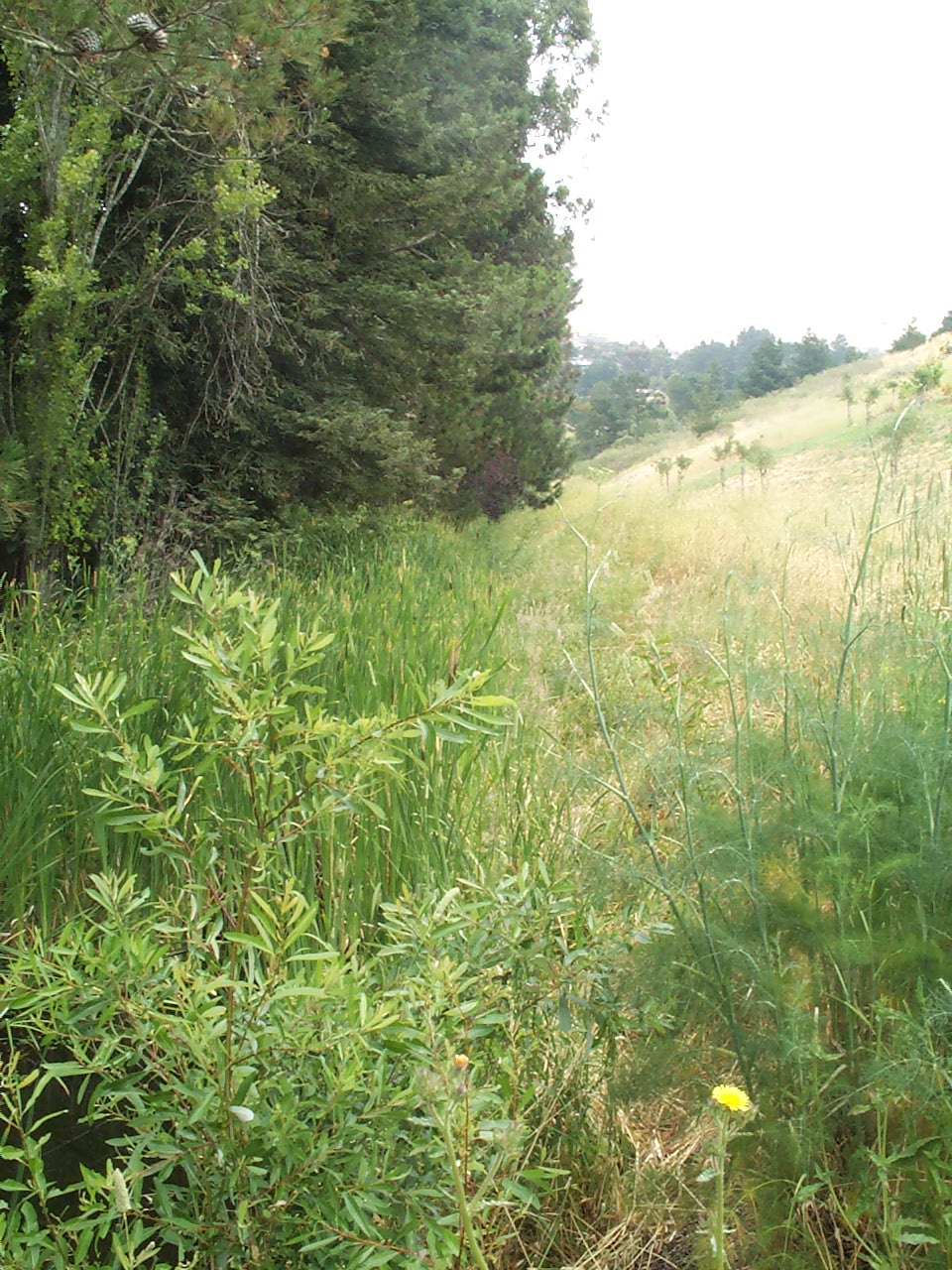
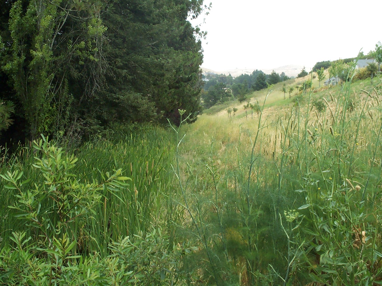
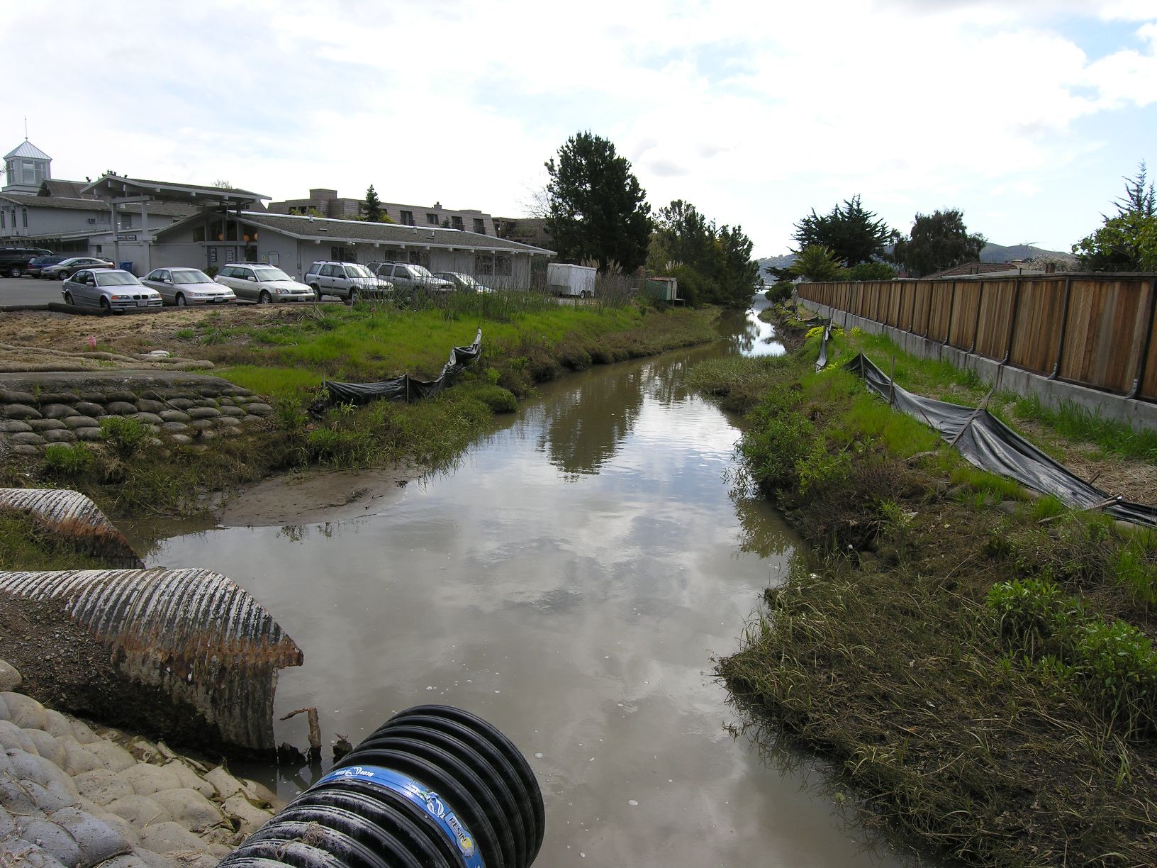
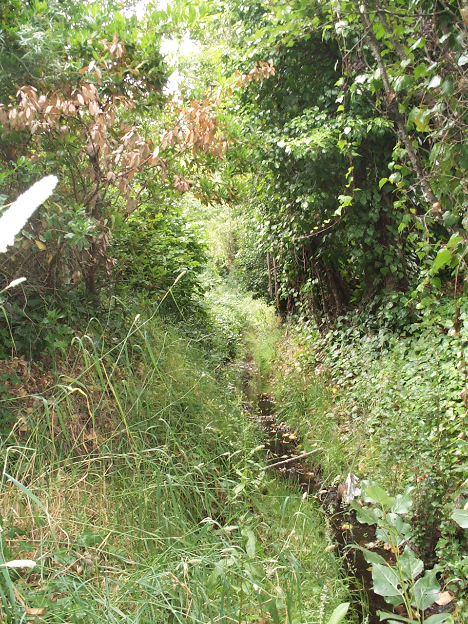
.jpg)
.jpg)
.jpg)
.jpg)
.jpg)
.2.jpg)
.2.jpg)
.jpg)
.jpg)
.jpg)