
| Area | Corte Madera Creek |
| Topic | Climate: Annual Rainfall in the Ross Creek Calwater 1902-2000 |
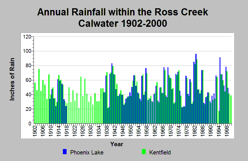
| Caption: This chart shows annual rainfall totals recorded at Ross Creek Calwater raingages between 1902 and 2000. The Phoenix Lake (DWR gage # E10 6853 00) and Kentfield (DWR gage # E20 4500 00) raingages are shown. Extended dry periods occurred between 1917 to 1934, 1944 to 1950, 1959 to 1962, and 1987 to 1994 (excluding 1993). Extended wet periods occurred between 1914 to 1916, 1940 to 1943, 1951 to 1953, 1967 to 1974 (excluding 1968 and 1972), and 1995 to 1999. The reported rainfall data are point measurements and do not represent the spatial variations existing throughout the entire Calwater planning watershed or the Corte Madera Creek sub-basin. See Info Links for more information. | |
 |
To learn more about this topic click Info Links .
To view additional information (data source, aquisition date etc.) about this page, click Metadata .
To view the table with the chart's data, click Chart Table web page.
To download the table with the chart's data, click climate_rainfall_northbay_cdwr_1874_2002.dbf (size 45,144 bytes)
To download the table with the chart's data as an Excel spreadsheet, click climate_rainfall_northbay_cdwr_1874_2002.dbf.xls (size 26,332 bytes) .
| www.krisweb.com |