
| Area | Novato and Miller Creeks |
| Topic | Climate: Annual Rainfall in the Stafford Lake Calwater 1947-1991 |
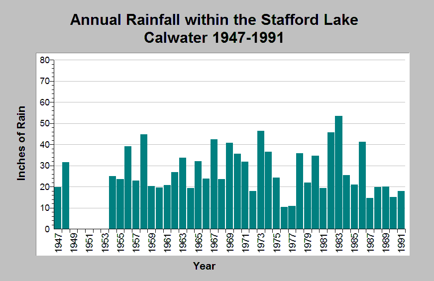
| Caption: This chart shows annual rainfall totals recorded at the Stafford Lake raingage (DWR gage # E10 4502 00) between 1947 and 1991, missing 1949-1953. This raingage is located within the Stafford Lake Calwater planning watershed in the Novato and Miller Creeks sub-basin. Notable dry periods occurred between 1976 and 1977, and 1987 to 1991. An extended wet period occurred between 1969 through 1972, excluding 1972. The reported rainfall data are point measurements and do not represent the spatial variations existing throughout the entire Calwater planning watershed or the Novato Creek sub-basin. See Info Links for more information. | |
 |
To learn more about this topic click Info Links .
To view additional information (data source, aquisition date etc.) about this page, click Metadata .
To view the table with the chart's data, click Chart Table web page.
To download the table with the chart's data, click climate_rainfall_northbay_cdwr_1874_2002.dbf (size 45,144 bytes)
To download the table with the chart's data as an Excel spreadsheet, click climate_rainfall_northbay_cdwr_1874_2002.dbf.xls (size 26,333 bytes) .
| www.krisweb.com |