
| Area | Petaluma River |
| Topic | Climate: Annual Rainfall in the Lower Petaluma Calwater 1874-2000 |
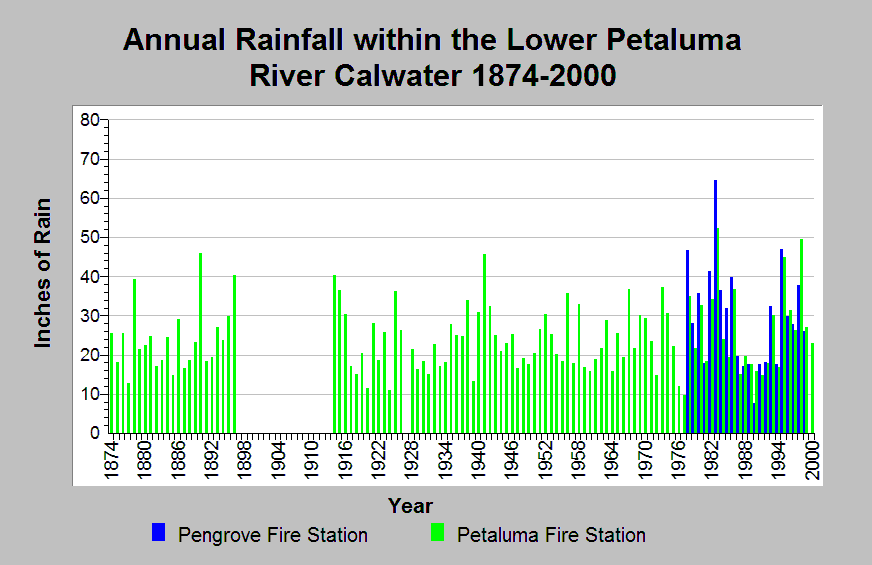
| Caption: This chart shows annual rainfall totals recorded at Lower Petaluma River Calwater raingages between 1874 and 2000, missing years 1897-1913, and 1927. The Pengrove Fire Station (DWR gage # E20 6792 04) and Petaluma Fire Station (DWR # E20 6826 00) raingages are shown. Notable dry periods occurred between 1917 through 1924, 1928 through 1934 and 1987 through 1994. Wet periods occurred between 1935 through 1942, 1978 through 1986, and 1995 through 1999. The reported rainfall data are point measurements and do not represent the spatial variations existing throughout the entire Calwater planning watershed or the Petaluma River sub-basin. See Info Links for more information. | |
 |
To learn more about this topic click Info Links .
To view additional information (data source, aquisition date etc.) about this page, click Metadata .
To view the table with the chart's data, click Chart Table web page.
To download the table with the chart's data, click climate_rainfall_northbay_cdwr_1874_2002.dbf (size 45,144 bytes)
To download the table with the chart's data as an Excel spreadsheet, click climate_rainfall_northbay_cdwr_1874_2002.dbf.xls (size 26,333 bytes) .
| www.krisweb.com |