
| Area | Petaluma River |
| Topic | Climate: Annual Rainfall in the Lynch Creek Calwater 1931-1962 |
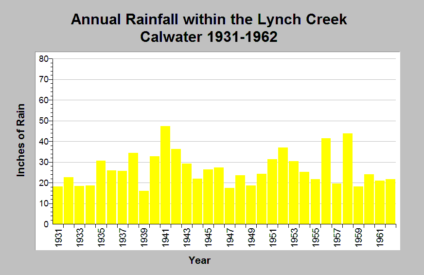
| Caption: This chart shows annual rainfall totals recorded at the Pengrove 1.5N raingage (DWR gage # F90 6792 03) between 1931 and 1962. This raingage is located within the Lynch Creek Calwater planning watershed in the Petaluma River sub-basin. Wet periods occurred between 1940 to 1943 and 1951 to 1953. The reported rainfall data are point measurements and do not represent the spatial variations existing throughout the entire Calwater planning watershed or the Adobe Creek sub-basin. See Info Links for more information. | |
 |
To learn more about this topic click Info Links .
To view additional information (data source, aquisition date etc.) about this page, click Metadata .
To view the table with the chart's data, click Chart Table web page.
To download the table with the chart's data, click climate_rainfall_northbay_cdwr_1874_2002.dbf (size 45,144 bytes)
To download the table with the chart's data as an Excel spreadsheet, click climate_rainfall_northbay_cdwr_1874_2002.dbf.xls (size 26,333 bytes) .
| www.krisweb.com |