
| Area | Petaluma River |
| Topic | Land Cover: EPA Land-Use, Petaluma River Sub-basin 1992 |
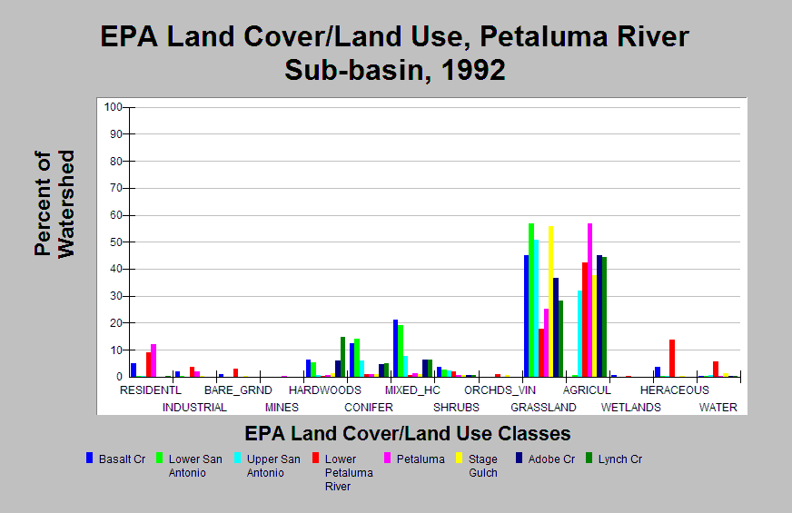
| Caption: This chart displays EPA Land Cover/Land Use data by Calwater Planning Watershed for the Petaluma Creek sub-basin. Classes are derived from a 1992 Landsat image. Petaluma Creek Calwaters are composed of 17-57% grassland area and 32-57% agriculture area (excluding Lower San Antonio). Conifer and hardwoods cover 5-21% of the Basalt Creek, Lower and Upper San Antonio, Adobe Creek, and Lynch Creek Calwaters. Basalt Creek, Lower Petaluma River and Petaluma contain 5%, 9%, and 12% residential area, respectively. Click on the Map tab to view the EPA Land Cover/Land Use GIS layer. Click on Info Links for more information. | |
 |
To learn more about this topic click Info Links .
To view additional information (data source, aquisition date etc.) about this page, click Metadata .
To view the table with the chart's data, click Chart Table web page.
To download the table with the chart's data, click epa_landcover_calwaters.dbf (size 4,370 bytes)
To download the table with the chart's data as an Excel spreadsheet, click epa_landcover_calwaters.dbf.xls (size 10,671 bytes) .
| www.krisweb.com |