
| Area | Petaluma River |
| Topic | WQ: Chlorpyrifos in Upper Petaluma River Watershed 1998 |
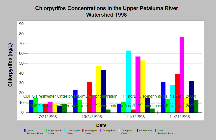
| Caption: Water quality monitoring was conducted in the upper Petaluma River watershed during 1998 to determine diazinon and chlorpyrifos concentrations during dry and storm events. This graph shows chlorpyrifos concentrations at several stations during four sampling events. The reference values shown in the graph represent the chlorpyrifos freshwater and saltwater Criterion Maximum Concentrations for the protection of aquatic life developed by the California Department of Fish and Game (Siepmann and Finlayson, 2000). Note that measurements below 30 ng/L should be considered "non-detect" and that more samples may have exceeded the criteria. All samples collected from the Lower Petaluma River station and individual samples collected from the Washington and Thompson Creek stations would be considered saltwater based on electrical conductivity measurements. See Info Links for more information and Picture for a map of the sampling locations. Data were collected by Petaluma Tree Planters. | |
 |
To learn more about this topic click Info Links .
To view additional information (data source, aquisition date etc.) about this page, click Metadata .
To view the table with the chart's data, click Chart Table web page.
To download the table with the chart's data, click wq_petaluma_chloravg_ptp_1998.xls_cross.db (size 4,096 bytes)
To download the table with the chart's data as an Excel spreadsheet, click wq_petaluma_chloravg_ptp_1998.xls_cross.db.xls (size 4,096 bytes) .
| www.krisweb.com |