
| Area | Petaluma River |
| Topic | WQ: Conductivity in San Antonio Creek 1991-2001 |
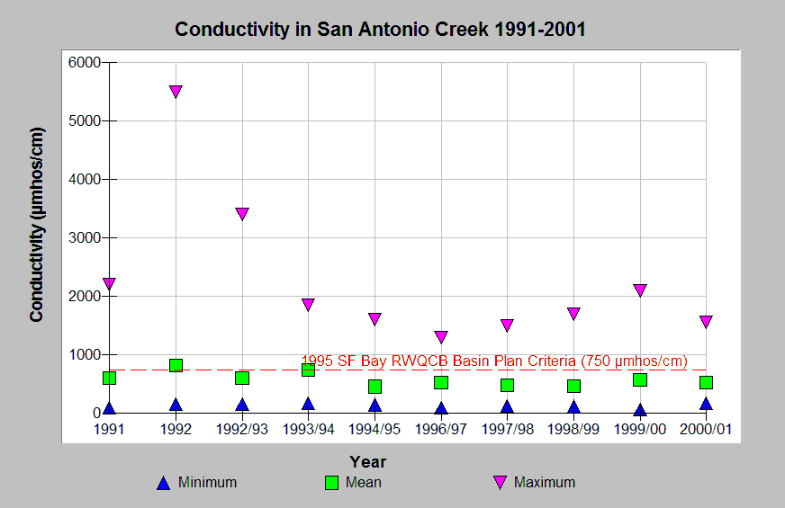
| Caption: Water quality parameters have been measured in an on-going program by the California Department of Fish and Game in various watersheds in Marin and Sonoma counties from 1991-2002. This graph shows minimum, mean, and maximum conductivity measurements in San Antonio Creek, a tributary of the Petaluma River, from 1991-2001. The reference value 750 µmhos/cm was the maximum criteria established by the San Francisco Bay Regional Water Quality Control Board Basin Plan. See Info Links for more information. | |
 |
To learn more about this topic click Info Links .
To view additional information (data source, aquisition date etc.) about this page, click Metadata .
To view the table with the chart's data, click Chart Table web page.
To download the table with the chart's data, click wq_sanant_cdfg_1991_2001.xls.db (size 6,144 bytes)
To download the table with the chart's data as an Excel spreadsheet, click wq_sanant_cdfg_1991_2001.xls.db.xls (size 10,259 bytes) .
| www.krisweb.com |