
| Area | Petaluma River |
| Topic | Climate: Annual Rainfall in the San Antonio Creek Sub-basin 1978-2000 |
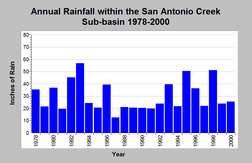
| Caption: This chart shows annual rainfall totals recorded at the Petaluma Cooley raingage (DWR gage # E20 6826 40) between 1978 and 2000. This raingage is located within the Lower San Antonio Creek Calwater planning watershed in the Petaluma River sub-basin. An extended dry period occurred between 1987 through 1992; preceded and followed by oscillating wet and dry years. The reported rainfall data are point measurements and do not represent the spatial variations existing throughout the entire Calwater planning watershed or the San Antonio Creek sub-basin. See Info Links for more information. | |
 |
To learn more about this topic click Info Links .
To view additional information (data source, aquisition date etc.) about this page, click Metadata .
To view the table with the chart's data, click Chart Table web page.
To download the table with the chart's data, click climate_rainfall_northbay_cdwr_1874_2002.dbf (size 45,144 bytes)
To download the table with the chart's data as an Excel spreadsheet, click climate_rainfall_northbay_cdwr_1874_2002.dbf.xls (size 26,333 bytes) .
| www.krisweb.com |