
| Area | Sonoma Creek |
| Topic | Climate: Annual Rainfall in Lower Calabazas Calwater 1959-2000 |
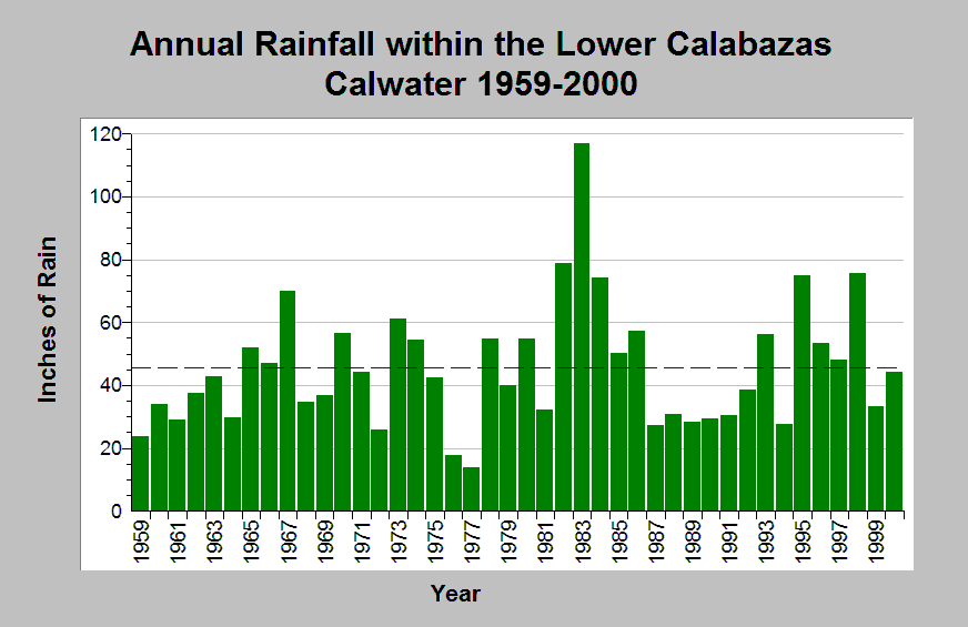
| Caption: This chart shows annual rainfall totals recorded at the Sonoma State Hospital raingage (DWR gage # E20 8351 03) between 1959 and 2000. This raingage is located within the Lower Calabazas Calwater planning watershed. The average annual rainfall is 46 inches. Oscillations between dry and wet periods are shown. For example, 1976 through 1981 was a dry period followed by a wet period between 1982 through 1986; then followed by another dry period between 1987 through 1995. The reported rainfall data are point measurements and do not represent the spatial variations existing throughout the entire Calwater planning watershed. See Info Links for more information. | |
 |
To learn more about this topic click Info Links .
To view additional information (data source, aquisition date etc.) about this page, click Metadata .
To view the table with the chart's data, click Chart Table web page.
To download the table with the chart's data, click climate_rainfall_northbay_cdwr_1874_2002.dbf (size 45,144 bytes)
To download the table with the chart's data as an Excel spreadsheet, click climate_rainfall_northbay_cdwr_1874_2002.dbf.xls (size 26,333 bytes) .
| www.krisweb.com |