
| Area | Sonoma Creek |
| Topic | Land Cover: USFS Veg Size, Sonoma Creek Sub-basin 1999 |
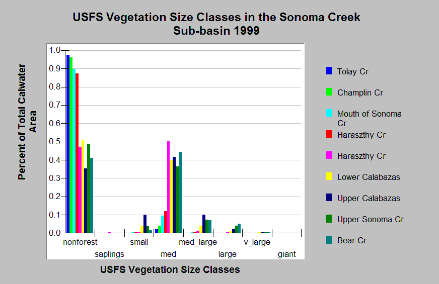
| Caption: This chart shows vegetation coverage by size classes in the Sonoma Creek sub-basin, derived from a 1999 Landsat image by the U.S. Forest Service. Forested areas are sparse in lower sub-basin Calwaters. Upper sub-basin Calwaters have approximately 50% forest area. The forested areas mainly contain medium trees with few large, medium large, and small trees. The vegetation classification is accurate at a one-hectare scale and is suitable for stand classification. Click on Map to see spatial data. Vegetation is classified according to diameter at breast height (DBH): Giant > 50", Very Large = 40-50" DBH, Large = 30-39.9" DBH, Medium/Large = 20-29.9" DBH, Medium = 12-19.9" DBH, Small = 5-11.9" DBH, Saplings = 1-4.9" DBH, Non-Forest = No trees, shrubs, grass, bare soil. Click on Info Links for more information. | |
 |
To learn more about this topic click Info Links .
To view additional information (data source, aquisition date etc.) about this page, click Metadata .
To view the table with the chart's data, click Chart Table web page.
To download the table with the chart's data, click veg_usfs_sizeclass_northbay_charttable.dbf (size 2,850 bytes)
To download the table with the chart's data as an Excel spreadsheet, click veg_usfs_sizeclass_northbay_charttable.dbf.xls (size 10,752 bytes) .
| www.krisweb.com |