
| Area | Sonoma Creek |
| Topic | Climate: Annual Rainfall in Upper Calabazas Calwater 1941-1982 |
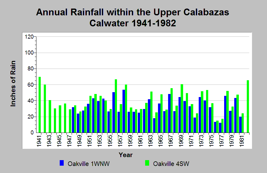
| Caption: This chart displays annual rainfall totals recorded at Upper Calabazas Calwater planning watershed raingages between 1941 and 1982. The Oakville 1WNW (DWR gage # E30 6351 00) and Oakville 4SW (DWR gage # E30 6354 00) raingages are shown. More rainfall accumulation is seen at the Oakville 4SW raingage for every giving year of record. Local orthographic effects explain this variation. The raingages differ in elevation by approximately 1300-feet with the Oakville 4SW raingage at a higher elevation than the Oakville 1WNW gage. Note that the reported rainfall data are point measurements and do not represent the spatial variations existing throughout the entire Calwater planning watershed. See Info Links for more information. | |
 |
To learn more about this topic click Info Links .
To view additional information (data source, aquisition date etc.) about this page, click Metadata .
To view the table with the chart's data, click Chart Table web page.
To download the table with the chart's data, click climate_rainfall_northbay_cdwr_1874_2002.dbf (size 45,144 bytes)
To download the table with the chart's data as an Excel spreadsheet, click climate_rainfall_northbay_cdwr_1874_2002.dbf.xls (size 26,333 bytes) .
| www.krisweb.com |