
| Area | Americano Creek |
| Topic | Climate: Americano Creek Annual Rainfall 1951-2000 |
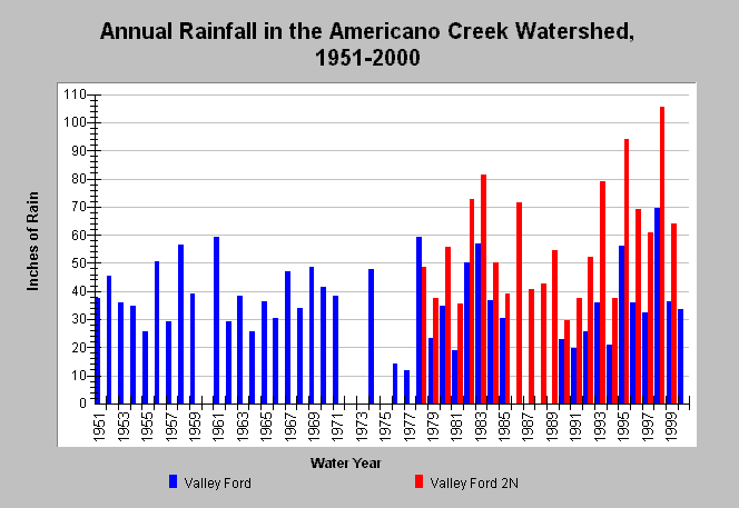
| Caption: This chart shows annual rainfall totals recorded at gauging stations within the Americano Creek watershed between 1951 and 2000. The gauging stations are both located in the Ebabias Calwater and are as follows: Valley Ford (DWR # F90 9231 02) and Valley Ford 2N (DWR # F90 9231 21). Valley Ford gauging station is located at an elevation of 80 feet, while, Valley Ford 2N gauging station is located at 400 feet elevation. The latter has higher rainfall than the former because of the orographic effect where precipitation increases in areas of higher relief. Blanks indicate no data. Data were provided by the California Department of Water Resources. See Map for gauge locations and Info Links for more information. | |
 |
To learn more about this topic click Info Links .
To view additional information (data source, aquisition date etc.) about this page, click Metadata .
To view the table with the chart's data, click Chart Table web page.
To download the table with the chart's data, click rain_annual_esteroamericano.dbf (size 1,530 bytes) .
| www.krisweb.com |