
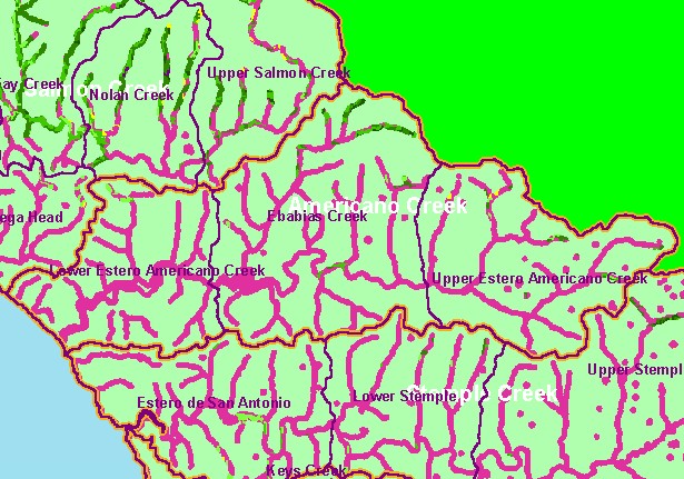
| Area | Americano Creek |
| Topic | Land Cover: USFS Veg Size in Americano Creek Riparian Zones 1994 |
| This is a map of 1994 USFS Landsat vegetation size data within 90-meter riparian buffer zones in the Americano Creek sub-basin. There are few areas of mature riparian forest that show on this map, but the data are averaged into polygons at least one hectare in size, so some individual trees or small patches may not be displayed. The vegetation classification is accurate at a one-hectare scale (approximately 11 pixels) and is suitable for stand classification. Data provided by the U.S. Forest Service Spatial Analysis Lab in Sacramento, CA. Scale = 1:133,107 . | |||
 |
 |
||
To view metadata about a map layer, click on a link in the table below.
| Name of Layer in Map Legend | Metadata File Name |
|---|---|
| Calwater PWS (w/ labels) | calw22.shp.txt |
| Subbasins (w/ labels) | subbasins.shp.txt |
| Frame Project Outline | Unavailable |
| Lakes and Reservoirs (Marin only) | Unavailable |
| USFS Riparian Veg Size (1994) | vegsizebuf.tif.txt |
| USFS Vegetation Size (1994) | vegsize.tif.txt |
| Topo Map, North (1:24k scale) | Unavailable |
| Topo Map, South (1:24k scale) | Unavailable |
| Project Background | Unavailable |
| www.krisweb.com |