
| Area | Regional |
| Topic | Temperature: All West Marin-Sonoma Sites, MWAT by Year 1995-2002 |
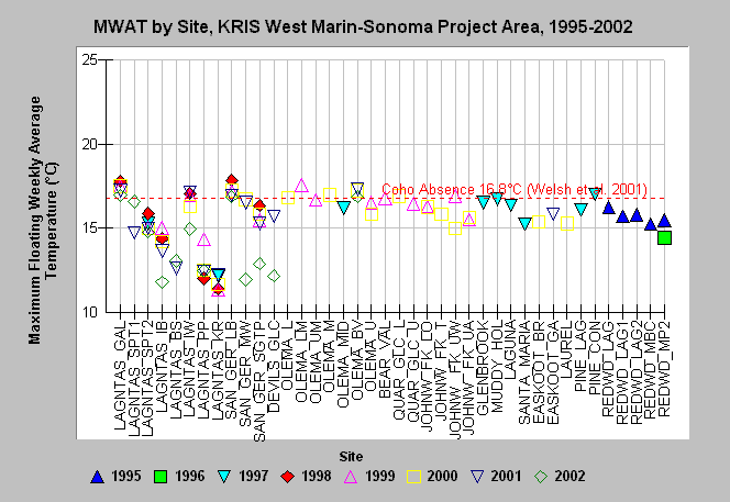
| Caption: The chart shows maximum floating weekly average temperature (MWAT) for each site in the KRIS West Marin-Sonoma Project Area with available data in the years 1995-2002. Sites begin on the left side of the chart (LAGNTAS_GAL) and are listed in north-south order with the southernmost site (REDWD_MP2) listed on the far right. Within each stream, sites are listed in downstream order with furthest upstream sites on the left. The coho stress value of 16.8 °C comes from Welsh et al. (2001). See Info Links for more information. Data were provided by Point Reyes National Seashore (PORE), Golden Gate National Recreation Area (GOGA), and Marin Municipal Water District (MMWD). | |
 |
To learn more about this topic click Info Links .
To view additional information (data source, aquisition date etc.) about this page, click Metadata .
To view the table with the chart's data, click Chart Table web page.
To download the table with the chart's data, click temp_wmarin_mwat_chart.dbf (size 8,837 bytes) .
| www.krisweb.com |