
| Area | Lagunitas Creek |
| Topic | Sediment: 6 Cheda Ranch Road - Bed Sub Surface Composition 1980-2000 |
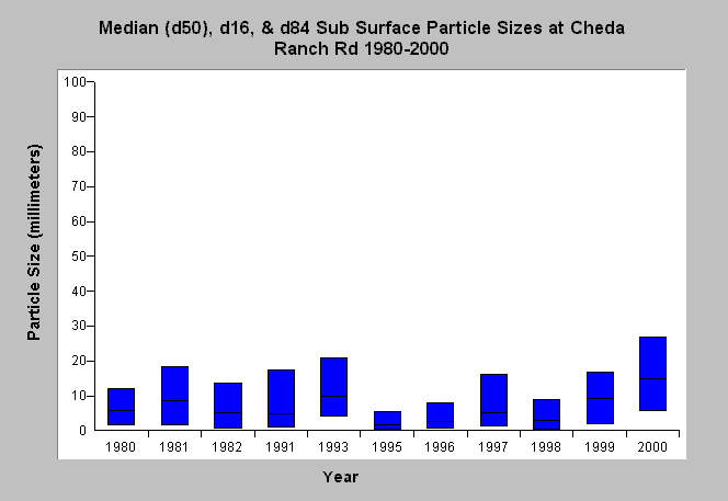
| Caption: This chart displays d16, d50 (median), and d84 particle sizes from sub surface samples of pool-tails measured in Lagunitas Creek at Cheda Ranch Road (monitoring site KL) from 1980 to 2000. Data were collected by Balance Hydrologics, Inc. for the Marin Municipal Water District. Bed core samples were not taken in locations where spawning might occur and are not intended to characterize spawning conditions (Prunuske Chatham, Inc., 2000). See Map to view sediment sampling locations and Info Links for more information. | |
 |
To learn more about this topic click Info Links .
To view additional information (data source, aquisition date etc.) about this page, click Metadata .
To view the table with the chart's data, click Chart Table web page.
To download the table with the chart's data, click sediment_lagunitas_bulkbed_sitekl.db (size 4,096 bytes) .
To view the table with the chart's source data, click Source Table web page.
To download the table with the chart's source data, click sediment_lag_bulkbed_bal_1980_2000.db (size 6,144 bytes)
| www.krisweb.com |