
| Area | Lagunitas Creek |
| Topic | WQ: Dissolved Oxygen in San Geronimo Creek 2000-2001 |
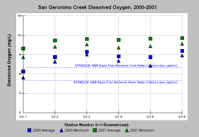
| Caption: Water quality parameters have been measured in an on-going program by the California Department of Fish and Game in various watersheds in Marin and Sonoma counties from 1991-2002. The graph shows dissolved oxygen measurements in stations (going downstream left to right) along San Geronimo Creek from 2000 and 2001. The reference values represent the minimum Cold water habitat (7.0 mg/L) and Warm water habitat (5.0 mg/L) criteria from the San Francisco Bay Regional Water Quality Control Board (SFRWQCB) 1995 Basin Plan (CRWQCB, 1995). See Map for water quality stations and Info Links for more information. | |
 |
To learn more about this topic click Info Links .
To view additional information (data source, aquisition date etc.) about this page, click Metadata .
To view the table with the chart's data, click Chart Table web page.
To download the table with the chart's data, click wq_sangeronimo_cdfg_do_2000_2001.db (size 4,096 bytes) .
To view the table with the chart's source data, click Source Table web page.
To download the table with the chart's source data, click wq_marinsonoma_cdfg_raw_1991_2002.xls.db (size 380,928 bytes)
| www.krisweb.com |