
| Area | Lagunitas Creek |
| Topic | WQ: Total Suspended Solids in Lagunitas Creek Small Tribs 1999-2001 |
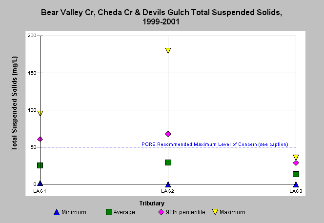
| Caption: Water quality parameters were measured by Point Reyes National Seashore in small tributaries of Lagunitas Creek, as well as a large tributary, Olema Creek and tributaries on the Point Reyes peninsula running into Drake's Bay and the Pacific Ocean from 1999-2001. The graph shows total suspended solid data for Bear Valley, Cheda Creek, and Devils' Gulch, small tributaries of Lagunitas Creek. The reference is the total suspended solids maximum level of concern (<50 mg/L) recommended by Point Reyes National Seashore (NPS, 2001). See the Map for location of water quality stations and see Info Links for more information. | |
 |
To learn more about this topic click Info Links .
To view additional information (data source, aquisition date etc.) about this page, click Metadata .
To view the table with the chart's data, click Chart Table web page.
To download the table with the chart's data, click wq_lag_avgmaxmin_pore_1999_2001.db (size 4,096 bytes) .
To view the table with the chart's source data, click Source Table web page.
To download the table with the chart's source data, click wq_all_avgmaxmin_pore_1999_2001.xls.db (size 14,336 bytes)
| www.krisweb.com |