
| Area | Lagunitas Creek |
| Topic | Flow: Lagunitas Creek at Pt Reyes Station, Monthly Average 1975-2001 |
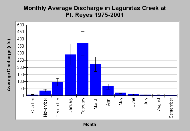
| Caption: This chart displays monthly average Lagunitas Creek discharge (cfs) at Pt. Reyes, CA. Higher flows occur during winter months in response to storm events and high base flows. Upstream flow regulation and lower base flows reduce the flows between June through October with average monthly stream flow less than 10 cfs. Whiskers bracket one standard error from the mean. Monthly flows are compiled by the U.S. Geological Survey from streamflow measurements gathered at USGS gage #11460600 from water years 1975 and 2001. See Info Links for more information. | |
 |
To learn more about this topic click Info Links .
To view additional information (data source, aquisition date etc.) about this page, click Metadata .
To view the table with the chart's data, click Chart Table web page.
To download the table with the chart's data, click flow_lagpointreyes_usgs_monthlyave_1974_2001.db (size 4,096 bytes) .
To view the table with the chart's source data, click Source Table web page.
To download the table with the chart's source data, click flow_lagpointreyes_usgs_monthly_1974_2001.dbf (size 15,098 bytes)
| www.krisweb.com |