
| Area | Lagunitas Creek |
| Topic | Climate: Bear Valley HQ Annual Rainfall 1965-1998 |
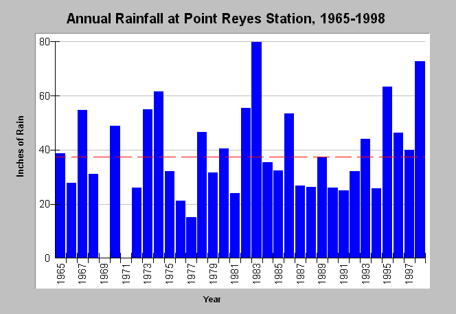
| Caption: The graph shows annual rainfall in inches at the Bear Valley Headquarters of the Point Reyes National Seashore (PORE) from 1965 to 1998. Note from the associated Chart Table that some monthly data are missing from WY 1969 and 1971; therefore, cumulative rainfall totals are not known for these years. The highest rainfall years were recent El Nińo weather patterns (1983 and 1998) with the years 1974 and 1995 next in rainfall total. The well recognized regional drought years of 1976-1977 have the lowest rainfall totals in the period of record. The red dashed line is the average rainfall. Data were collected by PORE. See Map for location of sampling site and Info Links for more information. | |
 |
To learn more about this topic click Info Links .
To view additional information (data source, aquisition date etc.) about this page, click Metadata .
To view the table with the chart's data, click Chart Table web page.
To download the table with the chart's data, click climate_rainmonthly_bvy_nps.dbf (size 3,304 bytes) .
| www.krisweb.com |