
| Area | Lagunitas Creek |
| Topic | Climate: Bear Valley HQ Monthly Rainfall 1965-1998 |
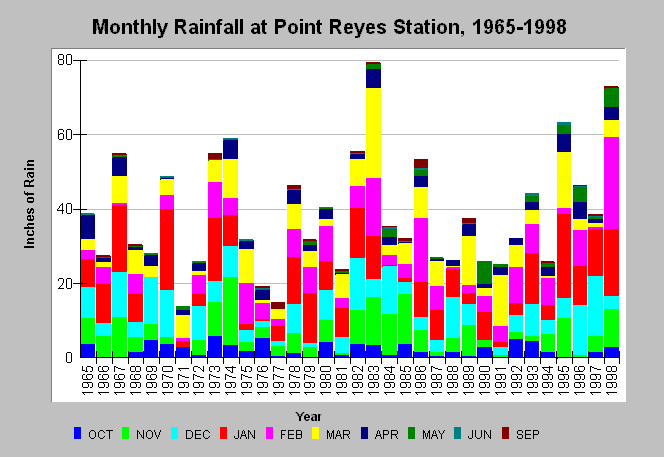
| Caption: The graph shows monthly rainfall in inches at Bear Valley Headquarters of the Point Reyes National Seashore (PORE) from 1965 to 1998. Note from the associated chart table that some monthly data are missing from WY 1969 and 1971; therefore it is not known how the annual rainfall from these years may compare to the remaining years. The highest rainfall years were recent El Ni˝o weather patterns (1983 and 1998). The months of July and August are not displayed above because of the limit to ten Y-axis values in KRIS but these months have little rainfall. Rainfall for some months in 1969 and 1971 are missing. Data were collected by PORE. See Map for location of sampling site and Info Links for more information. | |
 |
To learn more about this topic click Info Links .
To view additional information (data source, aquisition date etc.) about this page, click Metadata .
To view the table with the chart's data, click Chart Table web page.
To download the table with the chart's data, click climate_rainmonthly_bvy_nps.dbf (size 3,304 bytes) .
| www.krisweb.com |