
| Area | Lagunitas Creek |
| Topic | Flow: San Geronimo Cr at Lagunitas Rd Bridge - Monthly Ave 1980-2001 |
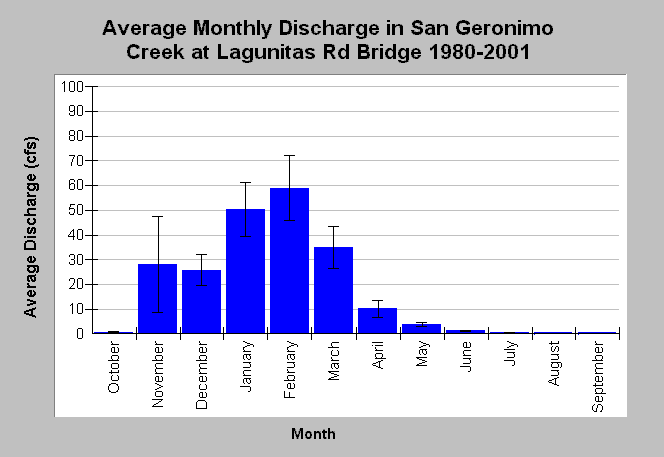
| Caption: This chart displays average monthly discharge (cfs) in San Geronimo Creek at the Lagunitas Road Bridge. Higher flows occur during winter months in response to storm events and high base flows. Low base flows between May through October reduce the average monthly stream flow to less than 5 cfs. Whiskers bracket one standard error from the mean. Monthly flows were compiled from stream gauge measurements gathered between water years 1980 and 2001. Data were collected by Balance Hydrologics, Inc. for the Marin Municipal Water District. See Info Links for more information. | |
 |
To learn more about this topic click Info Links .
To view additional information (data source, aquisition date etc.) about this page, click Metadata .
To view the table with the chart's data, click Chart Table web page.
To download the table with the chart's data, click flow_geronimo_lagbridge_monthlyave_1980_2001.db (size 4,096 bytes) .
To view the table with the chart's source data, click Source Table web page.
To download the table with the chart's source data, click flow_geronimo_lagbridge_monthly_1980_2001.dbf (size 10,194 bytes)
| www.krisweb.com |