
| Area | Lagunitas Creek |
| Topic | Habitat: Lagunitas Creek Percent Habitat by Length 1992 |
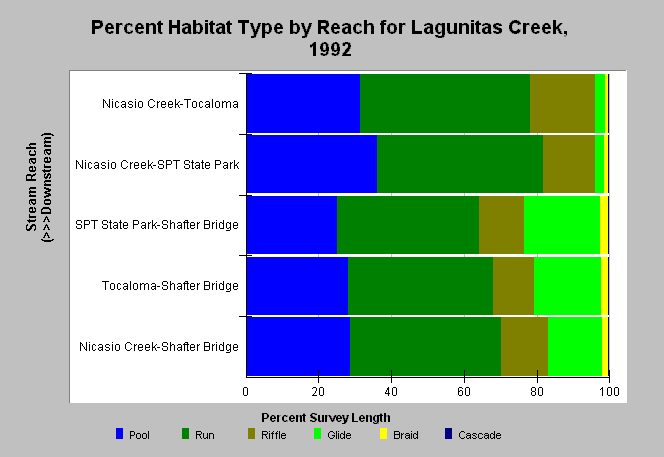
| Caption: The chart shows percent occurrence by length of six habitat categories taken from a habitat typing survey that covered 39,906.1 feet from Nicasio Creek to Shafter Bridge of Lagunitas Creek in 1992. Habitat typing was completed by Don Kelley and Associates for Marin Municipal Water District. These survey results differ substantially from 1998-1999, likely because Kelly and Associates (1992) categorized still water areas lacking depth as runs and more recent surveys called them shallow pools. The reach with the highest pool frequency is that below Samuel P. Taylor State Park down to Nicasio Creek with 36% of habitat by length comprised of pools. See Info Links for more information. | |
 |
To learn more about this topic click Info Links .
To view additional information (data source, aquisition date etc.) about this page, click Metadata .
To view the table with the chart's data, click Chart Table web page.
To download the table with the chart's data, click habitat_lag_mmwd_1992sum.dbf (size 1,815 bytes) .
To view the table with the chart's source data, click Source Table web page.
To download the table with the chart's source data, click habitat_lag_mmwd_1992raw.dbf (size 97,768 bytes)
| www.krisweb.com |