
| Area | Lagunitas Creek |
| Topic | Habitat: Lagunitas & San Geronimo Cr Percent Fish Cover 1998-1999 |
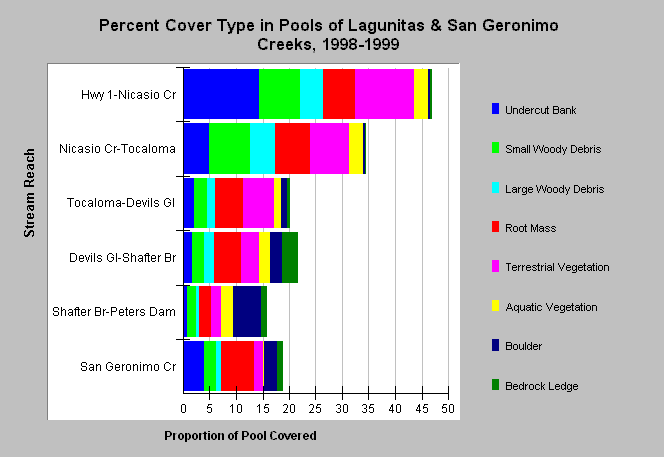
| Caption: The chart shows the average percent cover type in pools taken from a habitat typing survey of Lagunitas Creek and San Geronimo Creek in 1998 and 1999 conducted by Marin Municipal Water District. The surveys indicate increasing cover in downstream reaches of Lagunitas Creek with by far the highest values assigned to the Highway 1 to Nicasio Creek. The Shafter Bridge to Peters Dam reach had the least cover. Note that there are considerable differences in values for some reaches between the two years. Although it is possible that cover changed as a result of high flows in 1998 (El Nińo year), it is equally likely that there are differences that result from variation in visual observations. For this reason, habitat typing data are a good inventory tool but not useful for monitoring. Comparison of results from various reaches by the same crews, however, can be useful because observer differences are diminished. Data were provided by the Marin Municipal Water District. | |
 |
To learn more about this topic click Info Links .
To view additional information (data source, aquisition date etc.) about this page, click Metadata .
To view the table with the chart's data, click Chart Table web page.
To download the table with the chart's data, click habitat_fishcov_lag_mmwd_19981999sum.dbf (size 1,166 bytes) .
To view the table with the chart's source data, click Source Table web page.
To download the table with the chart's source data, click habitat_lagsg_mmwd_19981999raw.dbf (size 296,180 bytes)
| www.krisweb.com |