
| Area | Lagunitas Creek |
| Topic | Habitat: Lagunitas & San Geronimo Cr Substrate Percent 1998-1999 |
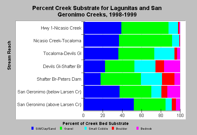
| Caption: The chart shows the average percent of the stream bottom covered by different substrate types taken from a habitat typing surveys of Lagunitas Creek and San Geronimo Creek in 1998 and 1999 conducted by Marin Municipal Water District. San Geronimo Creek above Larsen Creek shows signs of sediment problems with the bottom of the stream more than half covered in silt and sand. Reaches showing high components of bedrock may be trending towards gravel starved as high flows flush gravels but new recruitment is partially blocked by dams. See Info Links for more information. | |
 |
To learn more about this topic click Info Links .
To view additional information (data source, aquisition date etc.) about this page, click Metadata .
To view the table with the chart's data, click Chart Table web page.
To download the table with the chart's data, click habitat_subst_lagsgdg_mmwd_19981999sum.dbf (size 1,239 bytes) .
To view the table with the chart's source data, click Source Table web page.
To download the table with the chart's source data, click habitat_lagsg_mmwd_19981999raw.dbf (size 296,180 bytes)
| www.krisweb.com |