
| Area | Lagunitas Creek |
| Topic | Sediment: Bed Surface Composition - D50, Summary 1995-2000 |
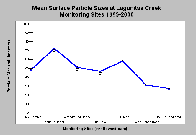
| Caption: This chart shows the average of median bed surface particle size (D50) from Wolman pebble counts in Lagunitas Creek from 1995 through 2000. Generally, the median bed surface particle size decreases downstream. The higher surface particle size in the Big Bend monitoring site may be as a result of coarse sediment contributions from Devils Gulch, which joins Lagunitas Creek just upstream, although channel confinement and gradient at that location may also play a role. Data were collected at monitoring sites annually by Balance Hydrologics, Inc. for the Marin Municipal Water District. Monitoring sites are listed upstream to downstream. Click Info Links for more information. Click Map to view a GIS map of sediment sampling locations. | |
 |
To learn more about this topic click Info Links .
To view additional information (data source, aquisition date etc.) about this page, click Metadata .
To view the table with the chart's data, click Chart Table web page.
To download the table with the chart's data, click sed_lagunitas_d50summery_1995_2000.db (size 4,096 bytes) .
To view the table with the chart's source data, click Source Table web page.
To download the table with the chart's source data, click sediment_lagunitas_wolman_balance_1979_2000.xls.db (size 16,384 bytes)
| www.krisweb.com |