| Area |
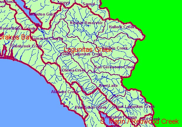
Lagunitas Creek |
| Topic |
Land Cover: EPA Land Use in Lagunitas Creek Sub-basin 1992 |
|
This is a map of the 1992 EPA Landcover/Landuse in Calwater Planning Watersheds in the Lagunitas Creek sub-basin. These data
are derived from a 1992 Landsat image and show coniferous forest near Mt Tamalpias but grasslands dominate areas near Nicasio
Reservoir and Olema along the San Andreas Fault. The hot pink near San Geronimo shows areas of development. Scale = 1:218,250 .
|
|
|
 |
 |
To view metadata about a map layer, click on a link in the table below.
| Name of Layer in Map Legend | Metadata File Name |
|---|
| Calwater PWS (w/ labels) | calw22.shp.txt |
| Subbasins (w/ labels) | subbasins.shp.txt |
| Subbasins (no labels) | subbasins.shp.txt |
| Streams (1:24k scale) | streams24.shp.txt |
| Frame Project Outline | Unavailable |
| EPA Landcover, Aggregated (1992)(TIFF) | lndcov2.tif.txt |
| EPA Landcover, Unaggregated (1992)(TIFF) | lndcov.tif.txt |
| Topo Map, North (1:24k scale) | Unavailable |
| Topo Map, South (1:24k scale) | Unavailable |
| Project Area Background | Unavailable |
