
| Area | Stemple Creek |
| Topic | Temperature: Stemple Creek/Estero de San Antonio 1988-1990 |
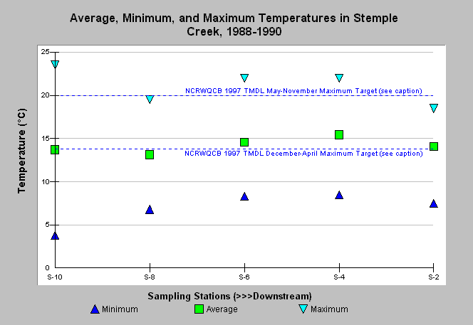
| Caption: The graph shows average, minimum, and maximum surface water temperatures measured at various sites in Stemple Creek and its estuary, Estero de San Antonio, during 1988-1990. Sampling occurred generally monthly for at least one station, with the number of temperature measurements at each station ranging from 7 to 22 samples for the monitoring period. Note that Stations S-2 through S-6 are estuarine. The reference values represent the maximum North Coast Regional Water Quality Control Board Stemple Creek TMDL thresholds to be met by 2004 from May-November (20°C) and December-April (13.8°C) at a specific freshwater and saline location (Salisbury, 1997). This monitoring was part of a water quality study of Americano and Stemple Creek watersheds by Merritt Smith Consulting for the City of Santa Rosa and U.S. Army Corps of Engineers. See Picture for a map of the sampling locations and Info Links for more details. | |
 |
To learn more about this topic click Info Links .
To view additional information (data source, aquisition date etc.) about this page, click Metadata .
To view the table with the chart's data, click Chart Table web page.
To download the table with the chart's data, click wq_stemple_msc_tempbyst_1988_1990.db (size 4,096 bytes) .
To view the table with the chart's source data, click Source Table web page.
To download the table with the chart's source data, click wq_stemple_msc_1988_1994.db (size 51,200 bytes)
| www.krisweb.com |