| Area |
Stemple Creek |
| Topic |
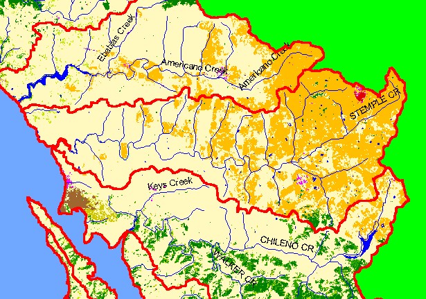
Map: 1C. EPA Landcover/Landuse, Stemple Creek Sub-basin |
|
This is a map of the EPA Landcover/Landuse in the Stemple Creek sub-basin derived from a 1992 Landsat image. This theme
shows that much of the basin is in pasture and grasslands and other types of agricultural activity also occur in about 50% of the
watershed. Residential areas show up as hot pink and the Sonoma County Central Landfill is shown in red in the northeast corner of
the basin. Data provided by the U.S. Environmental Protection Agency.
|
|
|
 |
 |
To view metadata about a map layer, click on a link in the table below.
| Name of Layer in Map Legend | Metadata File Name |
|---|
| Sub-basins (no labels) | subbasins.shp.txt |
| Streams (1:100k scale)(w/ labels) | streams100.shp.txt |
| Frame Project Outline | Unavailable |
| EPA Landcover, Aggregated (1992)(TIFF) | lndcov2.tif.txt |
| EPA Landcover, Unaggregated (1992)(TIFF) | lndcov.tif.txt |
| Topo Map, North (1:24k scale) | Unavailable |
| Topo Map, South (1:24k scale) | Unavailable |
| Project Area Background | Unavailable |
