Area/Topic  |  Bibliography   |  Background   |  Hypotheses   |  Home


KRIS West Marin-Sonoma: Map Page

Area Stemple Creek
Topic Map: 1E. USFS Riparian Veg Size, Stemple Creek Sub-basin 1994
 
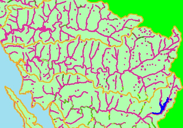
This is a map of 1994 USFS Landsat vegetation size data within 90-meter riparian buffer zones in the Stemple Creek sub-basin. There are few areas of mature riparian forest that show on this map, but the data are averaged into polygons at least one hectare in size, so some individual trees or small patches may not be displayed. Small dots indicate riparian areas around farm ponds. Data provided by the U.S. Forest Service Spatial Analysis Lab in Sacramento, CA. Data provided by the U.S. Forest Service Spatial Analysis Lab in Sacramento, CA. Scale = 1:154,551 .


 To view metadata about a map layer, click on a link in the table below.
Name of Layer in Map LegendMetadata File Name
Subbasins (no labels) subbasins.shp.txt
Frame Project Outline Unavailable
Lakes and Reservoirs (Marin only) Unavailable
USFS Riparian Veg Size (1994) vegsizebuf.tif.txt
USFS Vegetation Size (1994) vegsize.tif.txt
Topo Map, North (1:24k scale) Unavailable
Topo Map, South (1:24k scale) Unavailable
Project Background Unavailable


  www.krisweb.com