
| Area | S Marin/Redwood Creek |
| Topic | Land Cover: EPA Land Use in S. Marin Coast 1992 |
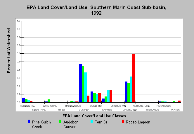
| Caption: This chart displays U.S. Environmental Protection Agency (EPA) Land Cover/Land Use data by Calwater Planning Watershed for the Southern Marin Coast sub-basin. Classes are derived from a 1992 Landsat image. Most Calwaters are dominated by coniferous forests but grasslands are also prominent, particularly on the Marin Headlands in the Rodeo Lagoon planning watershed. The Pine Gulch Calwater includes the town of Bolinas and has a slightly higher residential area. Additional areas contain mixed hardwood/conifer forest and shrubs. Residential areas exist in all basins. See Map to view the EPA Land Cover/Land Use GIS layer, showing the locations Land Cover/ Land Use classes presented and Info Links for more information. | |
 |
To learn more about this topic click Info Links .
To view additional information (data source, aquisition date etc.) about this page, click Metadata .
To view the table with the chart's data, click Chart Table web page.
To download the table with the chart's data, click epa_landcover_calwaters.dbf (size 6,582 bytes) .
To view the table with the chart's source data, click Source Table web page.
To download the table with the chart's source data, click epa_calwater_land_cover.dbf (size 7,986 bytes)
| www.krisweb.com |