
| Area | S Marin/Redwood Creek |
| Topic | Sediment: Redwood Creek Fines <0.841mm 1994 & 1995 |
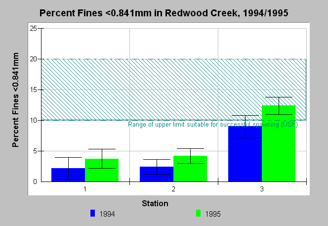
| Caption: This chart shows the mean levels of percent fine sediment less than 0.841mm measured at three stations in Redwood Creek in the years 1994 and 1995. Whiskers represent one standard error. These data were collected by University of San Francisco (USF) for the Golden Gate National Recreation Area. USF notes, from various sources, the upper limits of fine sediment associated with successful spawning. Station 1 was located near headwaters, Station 2 at Muir Woods Road mile 1.96, and Station 3 at Muir Beach parking lot. The lower gradient of Redwood Creek near Station 3 explains the accumulation of finer particles there. | |
 |
To learn more about this topic click Info Links .
To view additional information (data source, aquisition date etc.) about this page, click Metadata .
To view the table with the chart's data, click Chart Table web page.
To download the table with the chart's data, click sed_rawpct_redwood_usf_goga_1994_1995_cross.db (size 4,096 bytes) .
To view the table with the chart's source data, click Source Table web page.
To download the table with the chart's source data, click sed_raw_redwood_usf_goga_1994_1995.dbf (size 4,630 bytes)
| www.krisweb.com |