
| Area | S Marin/Redwood Creek |
| Topic | WQ: Dissolved Oxygen in Redwood Creek Above MBCSD 1999 |
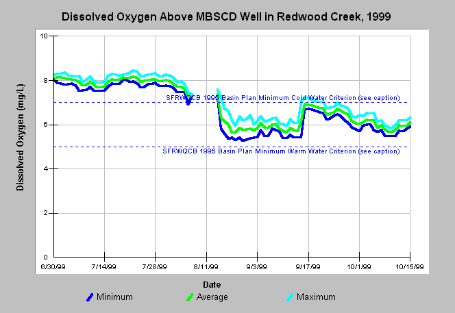
| Caption: Dissolved oxygen (D.O.) concentrations were measured at three stations (below Muir Beach Community Services District (MBCSD) well, above Muir Beach Community Services District well, and above Highway One) in Redwood Creek in 1999. This graph shows those measurements taken above the MBCSD well site. The reference values represent the minimum Cold water habitat (7.0 mg/L) and Warm water habitat (5.0 mg/L) criteria from the San Francisco Bay Regional Water Quality Control Board 1995 Basin Plan (CRWQCB, 1995). Dissolved oxygen concentrations at this point were above the Warm water criterion, but would have been stressful to salmonids from late August to mid-September, if gauge results are correct. D.O. readings from automated probes may be artificially low if detritus or decaying organic material gets caught on the sensor. Data were provided by the Golden Gate National Recreation Area. See Map for water quality monitoring locations and Info Links for more information. | |
 |
To learn more about this topic click Info Links .
To view additional information (data source, aquisition date etc.) about this page, click Metadata .
To view the table with the chart's data, click Chart Table web page.
To download the table with the chart's data, click wq_sumdissoxygen_redwood_1999.db (size 24,576 bytes) .
To view the table with the chart's source data, click Source Table web page.
To download the table with the chart's source data, click wq_dissoxygen_redwood_1999.dbf (size 644,156 bytes)
| www.krisweb.com |