
| Area | Salmon Creek |
| Topic | Land Cover: EPA Land Use in Salmon Creek Sub-basin 1992 |
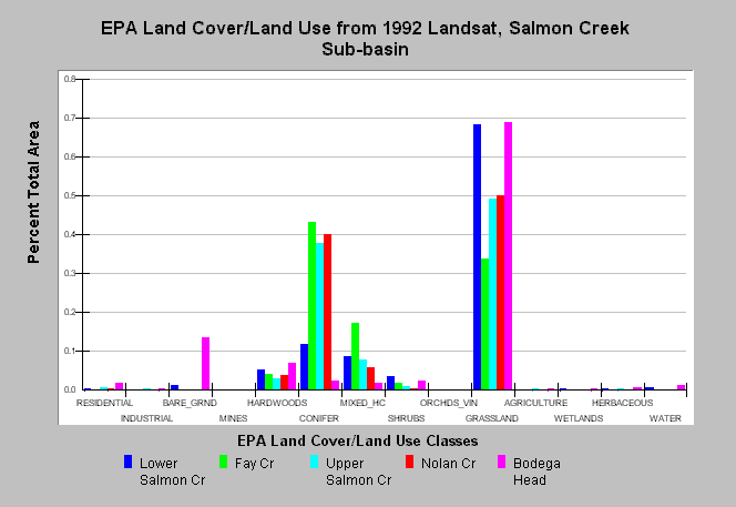
| Caption: This chart displays U.S. Environmental Protection Agency (EPA) Land Cover/Land Use data by Calwater Planning Watershed for the South Sonoma/Salmon Creek sub-basin. Classes are derived from a 1992 Landsat image. Calwater basins are mainly dominated by grasslands and also contain conifers, hardwoods and mixed conifer/hardwood forests. Conifer forests are the densest in Fay Creek, Upper Salmon Creek and Nolan Creek. Residential development is greatest in the Bodega Head Calwater. Data were provided by the U.S. Environmental Protection Agency. See Map to view spatial data and Info Links for more information. | |
 |
To learn more about this topic click Info Links .
To view additional information (data source, aquisition date etc.) about this page, click Metadata .
To view the table with the chart's data, click Chart Table web page.
To download the table with the chart's data, click epa_landcover_calwaters.dbf (size 6,582 bytes) .
To view the table with the chart's source data, click Source Table web page.
To download the table with the chart's source data, click epa_calwater_land_cover.dbf (size 7,986 bytes)
| www.krisweb.com |