
| Area | Tomales Bay |
| Topic | Land Cover: EPA Land Use in Tomales Bay Sub-basin 1992 |
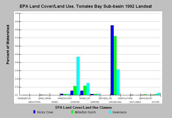
| Caption: This chart displays U.S. Environmental Protection Agency (EPA) Land Cover/Land Use data by Calwater Planning Watershed for the Tomales Bay sub-basin. Classes are derived from a 1992 Landsat image. Nicks Cove and Millerton Gulch are mainly dominated by grasslands and also contain Conifer and Mixed Hardwood/Conifer forests. Inverness is dominated by coniferous forest and also contains grasslands and mixed hardwood/conifer forest. See Map to view the EPA Land Cover/Land Use GIS layer, showing the locations Land Cover/ Land Use classes presented. See Info Links for more information. | |
 |
To learn more about this topic click Info Links .
To view additional information (data source, aquisition date etc.) about this page, click Metadata .
To view the table with the chart's data, click Chart Table web page.
To download the table with the chart's data, click epa_landcover_calwaters.dbf (size 6,582 bytes) .
To view the table with the chart's source data, click Source Table web page.
To download the table with the chart's source data, click epa_calwater_land_cover.dbf (size 7,986 bytes)
| www.krisweb.com |