
| Area | Tomales Bay |
| Topic | WQ: Ammonia (Unionized) TB East & South Small Tribs 1997-2000 |
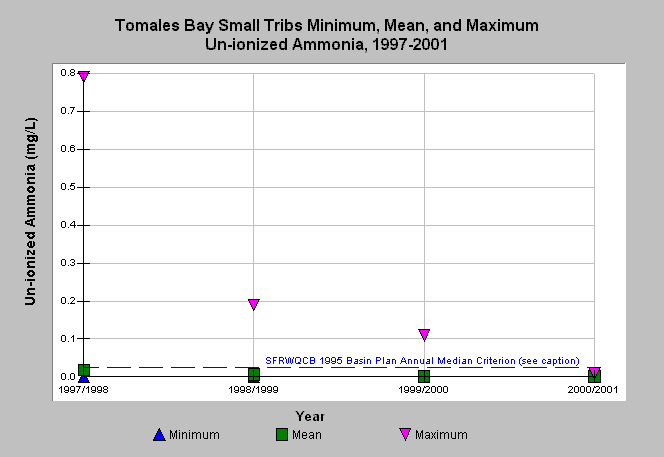
| Caption: Water quality parameters have been measured in an on-going program by the California Department of Fish and Game in various watersheds in Marin and Sonoma counties from 1991-2002. The graph shows un-ionized ammonia yearly minimum, mean, and maximum measurements taken in small tributaries along the eastern and southern shoreline of Tomales Bay from 1997-2001. The reference value represents the San Francisco Bay Regional Water Quality Control Board (SFRWQCB) 1995 Basin Plan annual mean criterion for un-ionized ammonia of 0.025 mg/L (CRWQCB, 1995). See Map for spatial data and Info Links for more information. | |
 |
To learn more about this topic click Info Links .
To view additional information (data source, aquisition date etc.) about this page, click Metadata .
To view the table with the chart's data, click Chart Table web page.
To download the table with the chart's data, click wq_tomales_cdfg_1997_2001.xls.db (size 4,096 bytes) .
To view the table with the chart's source data, click Source Table web page.
To download the table with the chart's source data, click wq_marinsonoma_cdfg_raw_1991_2002.xls.db (size 380,928 bytes)
| www.krisweb.com |