
| Area | Walker Creek |
| Topic | Flow: Monthly Average Walker Creek near Tomales 1959-1984 |
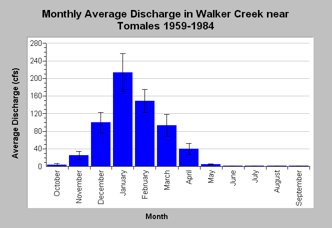
| Caption: This chart displays monthly average Walker Creek discharge (cfs) near Tomales, CA. Storm flow peaks generally occur during winter months and are caused by precipitation runoff. Lower base flows are prevalent between May through October with average monthly stream flow less than 5 cfs. Whiskers bracket one standard error from the mean. Monthly flows are compiled by the U.S. Geological Survey (USGS) from streamflow measurements gathered at USGS gage #11460800 from water years 1959 and 1984. See Info Links for more information. | |
 |
To learn more about this topic click Info Links .
To view additional information (data source, aquisition date etc.) about this page, click Metadata .
To view the table with the chart's data, click Chart Table web page.
To download the table with the chart's data, click flow_walker_tolmales_usgs_monthlyave_1959_1984.db (size 4,096 bytes) .
To view the table with the chart's source data, click Source Table web page.
To download the table with the chart's source data, click flow_walker_tolmales_usgs_monthly_1959_1984.dbf (size 14,132 bytes)
| www.krisweb.com |