
| Area | Walker Creek |
| Topic | Sediment: Walker Creek Erosion Types by Sub-Watershed 2001 |
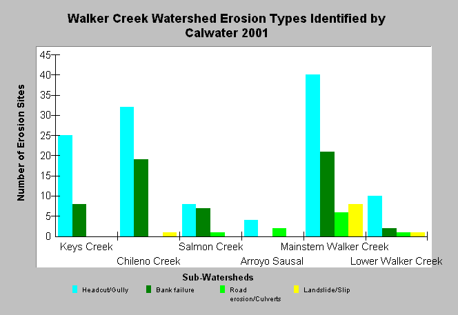
| Caption: The graph shows the type of erosion sources that were identified in sub-watersheds of Walker Creek. Headcuts and gullying are the dominate erosion types (56% of inventoried sites) and stream bank failures are second most common (28% of inventoried sites) in watersheds. These data were produced as part of an erosion inventory conducted by Prunuske Chatham Inc. for the Marin Resource Conservation District in 2001. The survey identified 196 sites throughout the Walker Creek watershed, downstream of Soulajule Dam and Laguna Lake. Inventories were conditional on landowner permission; therefore, figures do not represent all erosion sites within the watershed. See Picture for a map of the erosion sites and Info Links for more information. | |
 |
To learn more about this topic click Info Links .
To view additional information (data source, aquisition date etc.) about this page, click Metadata .
To view the table with the chart's data, click Chart Table web page.
To download the table with the chart's data, click sediment_walker_erosiontype_2001.dbf (size 910 bytes) .
| www.krisweb.com |