Area/Topic  |  Bibliography   |  Background   |  Hypotheses   |  Home


KRIS West Marin-Sonoma: Map Page

Area Walker Creek
Topic Map: 1E. USFS Riparian Veg Size, Walker Creek Sub-basin 1994
 
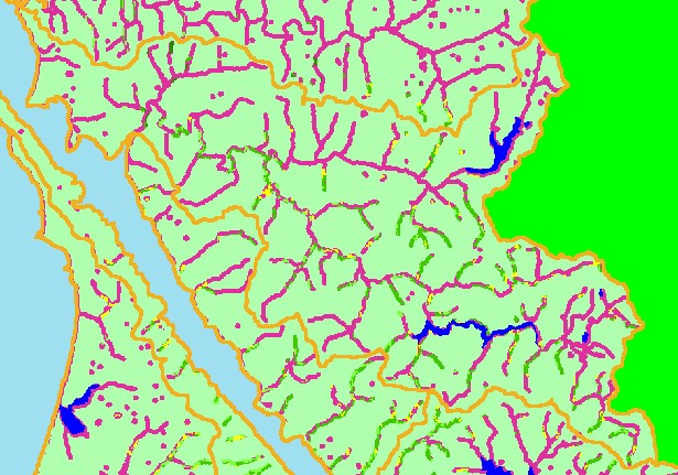
This is a map of the 1994 USFS Landsat vegetation size data within 90-meter riparian buffer zones in the Walker Creek sub-basin. Much of the riparian zone of Walker Creek appears to lack mature riparian forest although, because of the one hectare resolution, individual trees and small groves might not show in this coverage. Riparian character changes in upland areas which are forested, with trees typically in the Small/Medium size class (12-20" diameter). Data provided by the U.S. Forest Service Spatial Analysis Lab in Sacramento, CA. Scale = 1:173,102 .


 To view metadata about a map layer, click on a link in the table below.
Name of Layer in Map LegendMetadata File Name
Subbasins (no labels) subbasins.shp.txt
Frame Project Outline Unavailable
Lakes and Reservoirs (Marin only) Unavailable
USFS Riparian Veg Size (1994) vegsizebuf.tif.txt
USFS Vegetation Size (1994) vegsize.tif.txt
Topo Map, North (1:24k scale) Unavailable
Topo Map, South (1:24k scale) Unavailable
Project Background Unavailable


  www.krisweb.com