
| Area | Basinwide/Regional |
| Topic | Habitat: Box Plots of Percent Canopy by Sub-basin |
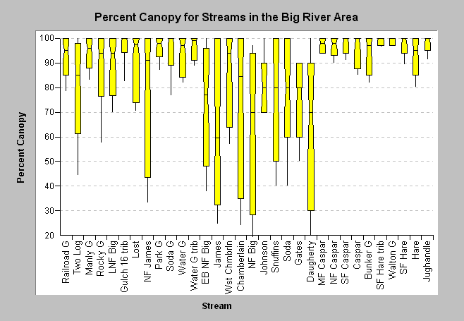
| Caption: The box-whisker plot for percent canopy shows the distribution of canopy cover measurements for each stream in the Big River area, as measured during CDFG stream surveys. Streams are arrayed by sub-basin. Some North Fork streams (the East Branch, James Creek, and the mainstem North Fork) and some South Fork streams (Johnson, Daugherty, Gates, Snuffins, and Soda) have greater most stream units with less than 80% riparian cover. James Creek had more than one-quarter of canopy measurements less than 50%. Query was run using KRIS Build Table functions. Data provided by California Department of Fish and Game, Sacramento. Click on Info Links for more information. | |
 |
To learn more about this topic click here .
To view the table with the chart's data, click Chart Table web page.
To download the table with the chart's data, click habqry_big.dbf (size 40,610 bytes) .
To see meta information about the data table used for this topic click here
To view the table with the chart's source data, click Source Table web page.
To download the table with the chart's source data, click habraw_big.dbf (size 5,051,928 bytes)
| www.krisweb.com |