
| Area | Basinwide/Regional |
| Topic | Sediment: Fines <0.85mm All MRC Sites Average, 2000 |
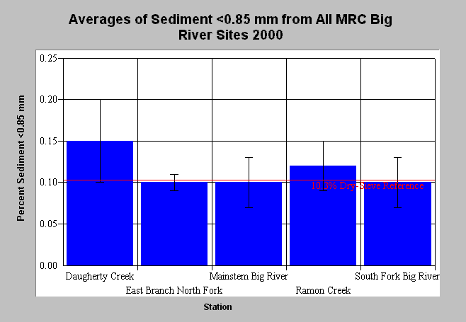
| Caption: The chart above shows percent fine sediment <0.85mm from dry-sieved McNeil bulk gravel samples. Values are averages of four pool tail-outs and the whiskers bracket one standard deviation from the mean. Average values exceed the adjusted percent fines target of 10.3% (red dashed line) in Daugherty and Ramon Creeks. Additionally, the fines target falls within one standard deviation at all sites. Data is from Mendocino Redwood Company. See Info Links for more information. Click on Picture to see a map of Mendocino Redwood Company monitoring stations. | |
 |
To learn more about this topic click here .
To view the table with the chart's data, click Chart Table web page.
To download the table with the chart's data, click sed_mcneil_averages.db (size 4,096 bytes) .
To see meta information about the data table used for this topic click here
To view the table with the chart's source data, click Source Table web page.
To download the table with the chart's source data, click big_mcneil.dbf (size 6,086 bytes)
| www.krisweb.com |