
| Area | Basinwide/Regional |
| Topic | Sediment: Fines <5.6mm All MRC Sites Average, 2000 |
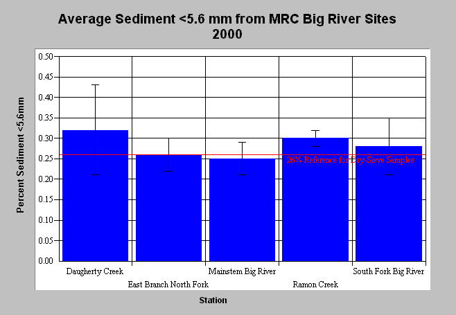
| Caption: Average McNeil dry-sieve results of percent fines <5.6mm from all Mendocino Redwood Company Big River sites are displayed above. The whiskers bracket one standard deviation from the mean. An adjusted fine sediment reference value of 26% is shown above for dry sieve fines less than 6.4mm. The adjusted reference is based on Shirazi and Seim (1979) and is not necessarily recognized by the EPA. Average fine sediment values exceeded the adjusted target in Daugherty and Ramon Creeks; however, TMDL thresholds are contained within the whiskers for all sites. See Info Links for more information. Click on Picture to see a map of Mendocino Redwood Company monitoring stations. | |
 |
To learn more about this topic click here .
To view the table with the chart's data, click Chart Table web page.
To download the table with the chart's data, click sed_mcneil_averages_5.6mm.db (size 4,096 bytes) .
To see meta information about the data table used for this topic click here
To view the table with the chart's source data, click Source Table web page.
To download the table with the chart's source data, click big_mcneil.dbf (size 6,086 bytes)
| www.krisweb.com |