
| Area | Caspar Creek |
| Topic | Sediment: Caspar Creek Cross Section 40+89, 1986-1999 Ribbon View |
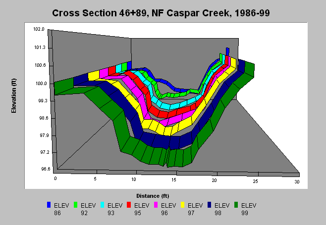
| Caption: In this cross section, there was a shift in the thalweg from the right bank in 1986 to the left bank in 1992. In following years, the site was relatively stable. See the next chart to see just the change between 1986 and 1993. There are 61 channel cross-section stations along the main stem of the North Fork of Caspar Creek, within the Caspar Creek Experimental Watershed in Jackson Demonstration State Forest, Fort Bragg, California. The referenced data set contains survey data for these cross-sections from 1986-1999. Additional data is in press (2001). Between 1986-1999, surveys were conducted every year except 1987 and 1994. | |
 |
To learn more about this topic click here .
To view the table with the chart's data, click Chart Table web page.
To download the table with the chart's data, click xs40_89.dbf (size 4,433 bytes) .
To see meta information about the data table used for this topic click here
To view the table with the chart's source data, click Source Table web page.
To download the table with the chart's source data, click rsl_xs_source.dbf (size 2,156,998 bytes)
| www.krisweb.com |