
| Area | Caspar Creek |
| Topic | Sediment: Turbidity, 1986-2000 |
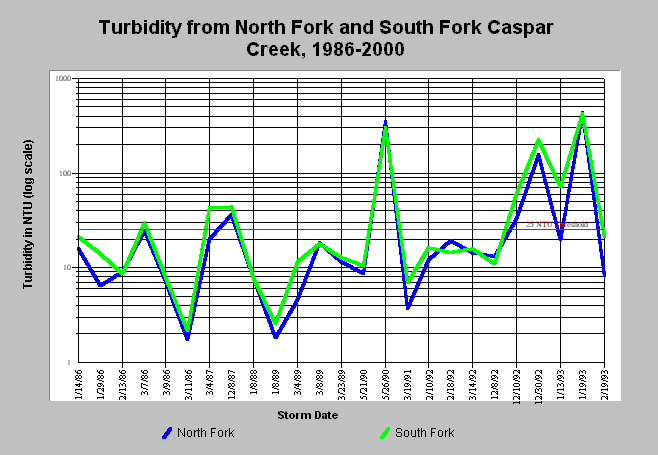
| Caption: Turbidity for the North Fork and South Fork Caspar Creek vary markedly among years and has a strong relationship with precipitation and runoff. Move the scrollbar in right side of this screen to change the dates of the chart. Differences in the relative yields are sometimes the result of different land management activities. The South Fork received much road building and timber harvest between 1967 and 1973. The North Fork was subject to 40% timber harvest in 1995. From 1985 to 1986, 67% of an 87-ha un-gauged tributary was clearcut and cable yarded immediately upstream of the North Fork gauging station. From 1989-1991 48% of the North Fork was logged using cable yarding. Landslides were known to deliver large amounts of sediment to the South Fork in 1973 and to the North Fork in 1995. The 25 NTU turbidity threshold is from Siegler et al. (1984). See Info Links for more on Caspar Creek. | |
 |
To learn more about this topic click here .
To view the table with the chart's data, click Chart Table web page.
To download the table with the chart's data, click turbidity.dbf (size 3,434 bytes) .
To see meta information about the data table used for this topic click here
| www.krisweb.com |