
| Area | North Fork Big River |
| Topic | USFS VegTypes: Chamberlain Creek CalWater 1994 |
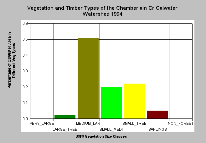
| Caption: This bar chart shows vegetation and timber types of the Chamberlain Creek Calwater planning watershed. The information was derived from a 1994 Landsat image by the U.S. Forest Service. This analysis technique calculates averages of vegetation stands and is not accurate at the pixel (30 meter) level. Scroll down for a key to classifications. The Chamberlain Creek had a large component of medium-large trees (20"-29.9") as of 1994, which comprised 51% of the watershed. Large trees (30-40") comprised 2% of the watershed while small to medium sized trees (12-19.9" diameter) made up 20% of the watershed. Small trees (5-11.9" diameter) made up 22% of the watershed and saplings (1-4.9" diameter) only 5%. The Non-Forest component is noted by its absence. Click on Picture to see an ArcView scene of the James Creek Calwater planning watershed showing vegetation types. Vegetation classifications are: VLargeTree = >40" in diameter LargeTree = Trees 30-39.9" in diameter Medium/Large Trees = 20-29.9" in diameter Small/Medium Trees = 12-19.9" in diameter Small Trees = 5-11.9" in diameter Non-Forest = No trees, shrubs, grass, bare soil | |
 |
To learn more about this topic click here .
To view the table with the chart's data, click Chart Table web page.
To download the table with the chart's data, click vegsummchart.dbf (size 2,228 bytes) .
To see meta information about the data table used for this topic click here
To view the table with the chart's source data, click Source Table web page.
To download the table with the chart's source data, click vegsummstat.dbf (size 14,792 bytes)
| www.krisweb.com |